Related Research Articles

Limestone is a type of carbonate sedimentary rock which is the main source of the material lime. It is composed mostly of the minerals calcite and aragonite, which are different crystal forms of CaCO3. Limestone forms when these minerals precipitate out of water containing dissolved calcium. This can take place through both biological and nonbiological processes, though biological processes, such as the accumulation of corals and shells in the sea, have likely been more important for the last 540 million years. Limestone often contains fossils which provide scientists with information on ancient environments and on the evolution of life.

Chalk is a soft, white, porous, sedimentary carbonate rock. It is a form of limestone composed of the mineral calcite and originally formed deep under the sea by the compression of microscopic plankton that had settled to the sea floor. Chalk is common throughout Western Europe, where deposits underlie parts of France, and steep cliffs are often seen where they meet the sea in places such as the Dover cliffs on the Kent coast of the English Channel.

Marl is an earthy material rich in carbonate minerals, clays, and silt. When hardened into rock, this becomes marlstone. It is formed in marine or freshwater environments, often through the activities of algae.

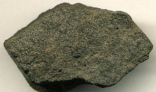
Chert is a hard, fine-grained sedimentary rock composed of microcrystalline or cryptocrystalline quartz, the mineral form of silicon dioxide (SiO2). Chert is characteristically of biological origin, but may also occur inorganically as a chemical precipitate or a diagenetic replacement, as in petrified wood.

A loess is a clastic, predominantly silt-sized sediment that is formed by the accumulation of wind-blown dust. Ten percent of Earth's land area is covered by loesses or similar deposits.
Phosphorite, phosphate rock or rock phosphate is a non-detrital sedimentary rock that contains high amounts of phosphate minerals. The phosphate content of phosphorite (or grade of phosphate rock) varies greatly, from 4% to 20% phosphorus pentoxide (P2O5). Marketed phosphate rock is enriched ("beneficiated") to at least 28%, often more than 30% P2O5. This occurs through washing, screening, de-liming, magnetic separation or flotation. By comparison, the average phosphorus content of sedimentary rocks is less than 0.2%.

Cave popcorn, or coralloids, are small nodes of calcite, aragonite or gypsum that form on surfaces in caves, especially limestone caves. They are a common type of speleothem.
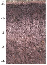
A soil horizon is a layer parallel to the soil surface whose physical, chemical and biological characteristics differ from the layers above and beneath. Horizons are defined in many cases by obvious physical features, mainly colour and texture. These may be described both in absolute terms and in terms relative to the surrounding material, i.e. 'coarser' or 'sandier' than the horizons above and below.
In geoscience, paleosol is an ancient soil that formed in the past. The definition of the term in geology and paleontology is slightly different from its use in soil science.

Lime is an inorganic material composed primarily of calcium oxides and hydroxides. It is also the name for calcium oxide which occurs as a product of coal-seam fires and in altered limestone xenoliths in volcanic ejecta. The International Mineralogical Association recognizes lime as a mineral with the chemical formula of CaO. The word lime originates with its earliest use as building mortar and has the sense of sticking or adhering.
This is an index of articles relating to soil.

The Kaiserstuhl is a range of hills in the state of Baden-Württemberg in southwest Germany with a maximum height of 556.6 metres (1,826 ft). It is of volcanic origin and located in the southwest of the state in the counties of Emmendingen and Breisgau-Hochschwarzwald. In terms of natural regions it is considered to be a part of the Upper Rhine Plain.

The Western Gulf coastal grasslands are a subtropical grassland ecoregion of the southern United States and northeastern Mexico. It is known in Louisiana as the "Cajun Prairie", Texas as "Coastal Prairie," and as the Tamaulipan pastizal in Mexico.

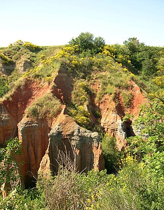
The Loess Hills are a formation of wind-deposited loess soil in the westernmost parts of Iowa and Missouri, and the easternmost parts of Nebraska and Kansas, along the Missouri River.
A fragipan is a diagnostic horizon in USDA soil taxonomy. They are altered subsurface soil layers that restrict water flow and root penetration. Fragipans are similar to a duripan in how they affect land-use limitations. In soil descriptions, they are commonly denoted by a Bx or Btx symbol. They often form in loess ground. The first record of fragipans is probably that by John Hardcastle in New Zealand in the 1880s.
Houdek is a type of soil composed of glacial till and decomposed organic matter. The soil series was established in 1955 in Spink County, South Dakota. It is unique to the United States, but in particular to South Dakota where it is the state soil.

There are seven soil deposits in India. They are alluvial soil, black soil, red soil, laterite soil, or arid soil, and forest and mountainous soil, marsh soil. These soils are formed by various geographical factors. They also have varied chemical properties. Sundarbans mangrove swamps are rich in marsh soil.

The geology of Surrey is dominated by sedimentary strata from the Cretaceous, overlaid by clay and superficial deposits from the Cenozoic.

The Western Corn Belt Plains is a Level III ecoregion designated by the Environmental Protection Agency (EPA) in seven U.S. states, though predominantly in Iowa.