White Earth River (Minnesota)

Last updated
White Earth River (Minnesota)
Country United States
Physical characteristics
Main source Minnesota

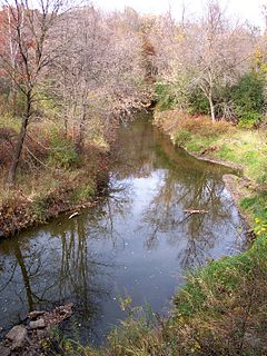
The White Earth River is a 26.2-mile-long (42.2 km) [1] tributary of the Wild Rice River of northwestern Minnesota in the United States. Via the Wild Rice River, the Red River of the North, Lake Winnipeg, and the Nelson River, it is part of the Hudson Bay watershed. It rises at the outlet of White Earth Lake and flows northwest through Mahnomen County, joining the Wild Rice River just east of the city of Mahnomen.

Wild Rice River (Minnesota) river in Minnesota, United States of America

The Wild Rice River is a tributary of the Red River of the North in northwestern Minnesota in the United States. It is 183 miles (295 km) long. Via the Red River, Lake Winnipeg and the Nelson River, it is part of the watershed of Hudson Bay. It is one of two Red River tributaries with the same name, the other being the Wild Rice River of North Dakota.

Minnesota State of the United States of America

Minnesota is a state in the Upper Midwest, Great Lakes, and northern regions of the United States. Minnesota was admitted as the 32nd U.S. state on May 11, 1858, created from the eastern half of the Minnesota Territory. The state has a large number of lakes, and is known by the slogan the "Land of 10,000 Lakes". Its official motto is L'Étoile du Nord.

United States Federal republic in North America

The United States of America (USA), commonly known as the United States or America, is a country comprising 50 states, a federal district, five major self-governing territories, and various possessions. At 3.8 million square miles, the United States is the world's third or fourth largest country by total area and is slightly smaller than the entire continent of Europe's 3.9 million square miles. With a population of over 327 million people, the U.S. is the third most populous country. The capital is Washington, D.C., and the largest city by population is New York City. Forty-eight states and the capital's federal district are contiguous in North America between Canada and Mexico. The State of Alaska is in the northwest corner of North America, bordered by Canada to the east and across the Bering Strait from Russia to the west. The State of Hawaii is an archipelago in the mid-Pacific Ocean. The U.S. territories are scattered about the Pacific Ocean and the Caribbean Sea, stretching across nine official time zones. The extremely diverse geography, climate, and wildlife of the United States make it one of the world's 17 megadiverse countries.

See also

Related Research Articles

Mahnomen County, Minnesota County in the United States

Mahnomen County is a county in the U.S. state of Minnesota. As of the 2010 United States Census, the population was 5,413. Its county seat is Mahnomen.

White Earth Indian Reservation

The White Earth Indian Reservation is the home to the White Earth Band, located in northwestern Minnesota. It is the largest Indian reservation in that state by land area. The reservation includes all of Mahnomen County, plus parts of Becker and Clearwater counties in the northwest part of the state, along the Wild Rice and White Earth rivers. It is about 225 miles (362 km) from Minneapolis-St. Paul and roughly 65 miles (105 km) from Fargo-Moorhead.

Rice Creek (Mississippi River tributary) river in Minnesota, United States of America

Rice Creek is a tributary of the Mississippi River in the northern suburbs of the Minneapolis–St. Paul metropolitan area of Minnesota in the United States. It is approximately 28 miles (45 km) long and drains a watershed of 201 square miles (520 km2).

Sand Hill River river in the United States of America

The Sand Hill River is a 101-mile-long (163 km) tributary of the Red River of the North in northwestern Minnesota in the United States. Via the Red River, Lake Winnipeg, and the Nelson River, it is part of the watershed of Hudson Bay, and drains an area of 475 square miles (1,230 km2).

The Beaver River is a 23.4-mile-long (37.7 km) river in Lake County, Minnesota. It flows into Lake Superior.

The Black River is a 33.7-mile-long (54.2 km) tributary of the Red Lake River of Minnesota in the United States. Via the Red Lake River, the Red River of the North, Lake Winnipeg, and the Nelson River, it is part of the Hudson Bay watershed.

The Clearwater River is a 147-mile-long (237 km) tributary of the Red Lake River of Minnesota in the United States. Via the Red Lake River, the Red River of the North, Lake Winnipeg, and the Nelson River, it is part of the Hudson Bay watershed.

The Cross River is a 20.4-mile-long (32.8 km) river in northern Minnesota, the United States. It is a direct tributary of Lake Superior.

Devil Track River river in the United States of America

The Devil Track River is an 8.7-mile-long (14.0 km) river in northeastern Minnesota, the United States. It begins at the outlet of Devil Track Lake and flows southeast to Lake Superior east of Croftville.

The Egg River is a 16-mile-long (26 km) tributary of the Otter Tail River of Minnesota in the United States. It flows through a chain of lakes in the Tamarac National Wildlife Refuge and the White Earth Indian Reservation in Becker County, Minnesota.

The Lost River is a 76.2-mile-long (122.6 km) tributary of the Clearwater River of northwestern Minnesota in the United States. Via the Clearwater River, the Red Lake River, the Red River of the North, Lake Winnipeg, and the Nelson River, it is part of the watershed of Hudson Bay.

Marsh River (Minnesota) river in the United States of America

The Marsh River, located in Minnesota, is a 49.9-mile-long (80.3 km) tributary of the Red River of the North. It rises less than 600 feet (180 m) from the Wild Rice River, east of the city of Ada, and flows generally northwest, entering the Red River 2 miles (3 km) northwest of Shelly. The Marsh River flows entirely within Norman County.

The Moose River is a 22.5-mile-long (36.2 km) tributary of Thief Lake in northwestern Minnesota, the United States. The outflow from Thief Lake drains via the Thief River, Red Lake River, Red River of the North, Lake Winnipeg, and the Nelson River to Hudson Bay.

Onion River (Minnesota) river in the United States of America

The Onion River is a 6.1-mile-long (9.8 km) stream in northeastern Minnesota, the United States, flowing directly into Lake Superior.

The Otter River is a short connecting stream in Minnesota, flowing from Boulder Lake Reservoir into Island Lake Reservoir. The stream's length is 0.17 miles (0.27 km). It is within the Cloquet River watershed, north of Duluth.

The Pine River, also known as the White Pine River, is a 15.0-mile-long (24.1 km) tributary of the Saint Louis River in Minnesota, United States.

The Rice River is a 57.1-mile-long (91.9 km) tributary of the Mississippi River in northern Minnesota, United States. It rises in southeastern Aitkin County at the outlet of Porcupine Lake and flows generally north into Rice Lake National Wildlife Refuge, where it turns west and flows to the Mississippi 5 miles (8 km) northeast of Aitkin.

The Sandy River is a 28.8-mile-long (46.3 km) tributary of Red Lake in northwestern Minnesota in the United States.

The West Swan River is a 42.2-mile-long (67.9 km) tributary of the East Swan River of Minnesota, flowing to the Saint Louis River and eventually Lake Superior. The West Swan River flows into and out of Snowshoe Lake and Kelly Lake west of Hibbing. Presently there are problems with flowage, due to obstructions in the river. The mines that have polluted the river have left it facing severe problems.

References

  1. U.S. Geological Survey. National Hydrography Dataset high-resolution flowline data. The National Map, accessed June 8, 2011

Coordinates: 47°18′45″N95°56′55″W / 47.31246°N 95.94865°W / 47.31246; -95.94865

Geographic coordinate system Coordinate system

A geographic coordinate system is a coordinate system that enables every location on Earth to be specified by a set of numbers, letters or symbols. The coordinates are often chosen such that one of the numbers represents a vertical position and two or three of the numbers represent a horizontal position; alternatively, a geographic position may be expressed in a combined three-dimensional Cartesian vector. A common choice of coordinates is latitude, longitude and elevation. To specify a location on a plane requires a map projection.