
The Delmarva Peninsula, or simply Delmarva, is a large peninsula and proposed state on the East Coast of the United States, occupied by the vast majority of the state of Delaware and parts of the Eastern Shore of Maryland and Eastern Shore of Virginia.

Wicomico County is located in the southeastern part of the U.S. state of Maryland, on the Delmarva Peninsula. As of the 2020 census, the population was 103,588. The county seat is Salisbury. The county was named for the Wicomico River, which in turn derives its name from the Algonquian language words wicko mekee, meaning "a place where houses are built," apparently referring to a Native American town on the banks. The county is included in the Salisbury, MD-DE Metropolitan Statistical Area.

Delmar is a town in Wicomico County, Maryland, United States. The population was 3,003 at the 2010 census. It is included in the Salisbury, Maryland-Delaware Metropolitan Statistical Area. When the population is added to Delmar, Delaware, the town's total population is 4,600.

Salisbury is a city in and the county seat of Wicomico County, Maryland, United States. Salisbury is the largest city in the state's Eastern Shore region, with a population of 33,050 at the 2020 census. Salisbury is the principal city of the Salisbury, Maryland-Delaware Metropolitan Statistical Area. The city is the commercial hub of the Delmarva Peninsula, which was long devoted to agriculture and had a southern culture. It calls itself "The Comfortable Side of Coastal".

The Woolwich Ferry is a free vehicle and pedestrian ferry across the River Thames in East London, connecting Woolwich on the south bank with North Woolwich on the north. It is licensed and financed by London River Services, the maritime arm of Transport for London (TfL). Around two million passengers use the ferry each year.

A cable ferry is a ferry that is guided across a river or large body of water by cables connected to both shores. Early cable ferries often used either rope or steel chains, with the latter resulting in the alternative name of chain ferry. Both of these were largely replaced by wire cable by the late 19th century.
The Wicomico River is a 24.4-mile-long (39.3 km) tributary of the Chesapeake Bay on the eastern shore of Maryland. It drains an area of low marshlands and farming country in the middle Delmarva Peninsula.

The Eastern Shore of Maryland is a part of the U.S. state of Maryland that lies mostly on the east side of the Chesapeake Bay. Nine counties are normally included in the region. The Eastern Shore is part of the larger Delmarva Peninsula that Maryland shares with Delaware and Virginia.

Salisbury-Ocean City: Wicomico Regional Airport, or, more succinctly Salisbury Regional Airport, is located in unincorporated Wicomico County, Maryland, 5 miles (8.0 km) southeast from downtown Salisbury, Maryland, United States. Salisbury is the largest metropolitan area of Maryland's Eastern Shore with a population of 405,803 in the metropolitan statistical area, and is centrally located on the Delmarva Peninsula.

Transportation in the Commonwealth of Virginia is by land, sea and air. Virginia's extensive network of highways and railroads were developed and built over a period almost 400 years, beginning almost immediately after the founding of Jamestown in 1607, and often incorporating old established trails of the Native Americans.

Quantico is an unincorporated community and census-designated place in Wicomico County, Maryland, United States, along the former stage route from Vienna to the port of Whitehaven on the Wicomico River. It consists of approximately 35 homes on the Quantico Creek. The community lies four miles (6 km) from Hebron along Maryland Route 347. There are two churches, a general store, and a post office in the community. It is part of the Salisbury, Maryland-Delaware Metropolitan Statistical Area.

The Queen Anne’s Railroad was a railroad that ran between Love Point, Maryland, and Lewes, Delaware, with connections to Baltimore via ferry across the Chesapeake Bay. The Queen Anne's Railroad company was formed in Maryland in 1894, and received legislative authorization from Delaware in February 1895. The railroad's original western terminus was in Queenstown, Maryland, and was moved via a 13-mile (21 km) extension to Love Point in 1902, which shortened the ferry trip to Baltimore.

Maryland Route 349 is a state highway in the U.S. state of Maryland. Known as Nanticoke Road, the state highway runs 22.32 miles (35.92 km) from a dead end in Nanticoke east to U.S. Route 50 Business in Salisbury. The first segment of MD 349 was constructed by 1910 west of Salisbury. The modern highway reached Quantico by 1919, Bivalve by 1925, and its western terminus by 1933. The only major change to MD 349 since is a realignment near Salisbury in the mid-1950s.

Maryland Route 352 is an east–west state highway in the U.S. state of Maryland. The state highway runs 10.03 miles (16.14 km) between intersections with MD 349 near Bivalve on the west and near Quantico on the east. The Whitehaven Road portion of MD 352 was constructed as a state highway from Catchpenny west to Green Hill Creek in the early 1930s. The state highway was extended south to Whitehaven, the north landing of the Whitehaven Ferry, by 1946. The Capitola Road portion of MD 352 was originally designated MD 385 in the late 1940s and absorbed into MD 352 in the 1960s.

Maryland Route 362 is a state highway in the U.S. state of Maryland. Known as Mount Vernon Road, the state highway runs 6.23 miles (10.03 km) from Bobtown Road near Mount Vernon east to MD 675 in Princess Anne. MD 362 connects Princess Anne with northwestern Somerset County as well as southwestern Wicomico County via the Whitehaven Ferry. The state highway was constructed from U.S. Route 13 beginning in 1929. MD 363 was completed to Mount Vernon in the late 1930s.

Whitehaven Hotel is a historic hotel located at Whitehaven, Wicomico County, Maryland, United States. It is a three-story, U-shaped, steeply pitches mansard-roofed Second Empire-style frame structure. The center core of the hotel is a Federal side hall / parlor dwelling, erected around 1810–1815. The hotel interior retains much of its early and later 19th century woodwork.

Whitehaven Historic District is a national historic district in Whitehaven, Wicomico County, Maryland. It is located at the end of Whitehaven Road on the north bank of the Wicomico River. The Whitehaven Ferry that crosses the river here has been in continuous operation since 1688 or earlier. The district encompasses a late-19th century village, consisting of the Whitehaven Hotel, church, school, marine railway, and 24 houses dating from the 19th century, two 20th century and one 18th century dwellings. It is one of the oldest towns in this part of Maryland, authorized by the General Assembly in the late 17th century.

Whitehaven is an unincorporated community and census-designated place in Wicomico County, Maryland, United States. Its population was 43 as of the 2010 census. It is part of the Salisbury, Maryland-Delaware Metropolitan Statistical Area.
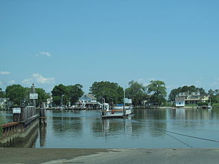
The Upper Ferry is a passenger and automobile cable ferry that crosses the Wicomico River in Eden, Maryland, located to the southwest of Salisbury. The ferry is operated by the Wicomico County Department of Public Works and runs between North Upper Ferry Road to the north and South Upper Ferry Road to the south. The ferry can carry a maximum of 6 passengers and 3 cars and has a weight limit of 10,000 pounds. The Upper Ferry operates from early morning until the evening every day of the year except county holidays, and is free. The ferry crossing takes about a minute and the ferry makes approximately 150 trips a day. In 2019, the ferry was overhauled and refurbished.
The Baltimore, Chesapeake and Atlantic railroad, nicknamed Black Cinders & Ashes, ran from Claiborne, Maryland, to Ocean City, Maryland. It operated 87 miles (140.0 km) of center-line track and 15.6 miles (25.11 km) of sidings. Chartered in 1886, the railroad started construction in 1889 and cost $2.356 million ($2024=79,895,000).

