
Harwich is a New England town on Cape Cod, in Barnstable County in the state of Massachusetts in the United States. At the 2020 census it had a population of 13,440. Harwich experiences a seasonal increase to roughly 37,000. The town is a popular vacation spot, located near the Cape Cod National Seashore. Harwich's beaches are on the Nantucket Sound side of Cape Cod. Harwich has three active harbors. Saquatucket, Wychmere and Allen Harbors are all in Harwich Port. The town of Harwich includes the villages of Pleasant Lake, West Harwich, East Harwich, Harwich Port, Harwich Center, North Harwich and South Harwich.

Cape Cod is a peninsula extending into the Atlantic Ocean from the southeastern corner of Massachusetts, in the northeastern United States. Its historic, maritime character and ample beaches attract heavy tourism during the summer months. The name Cape Cod, coined in 1602 by Bartholomew Gosnold, is the ninth oldest English place-name in the U.S.

Barnstable County is a county in the U.S. state of Massachusetts. At the 2020 census, the population was 228,996. The county seat is Barnstable. The county consists of Cape Cod and associated islands.

Monhegan is an island in the Gulf of Maine. A plantation, a minor civil division in the state of Maine falling between unincorporated area and a town, it is located approximately 12 nautical miles (22 km) off the mainland and is part of Lincoln County, Maine, United States. The population was 64 at the 2020 census. The plantation comprises its namesake island and the neighboring island of Manana. The island is accessible by scheduled boat service from Boothbay Harbor, New Harbor and Port Clyde. Visitors' cars are not allowed on the island. It was designated a United States National Natural Landmark for its coastal and island flora in 1966.

Woods Hole is a census-designated place in the town of Falmouth in Barnstable County, Massachusetts, United States. It lies at the extreme southwestern corner of Cape Cod, near Martha's Vineyard and the Elizabeth Islands. The population was 781 at the 2010 census.

Chatham is a town in Barnstable County, Massachusetts, United States. Chatham is located at the southeastern tip of Cape Cod and has historically been a fishing community. First settled by the English in 1664, the township was originally called Monomoit based on the indigenous population's term for the region. Chatham was incorporated as a town on June 11, 1712, and has become a summer resort area. The population was 6,594 at the 2020 census and can swell to 25,000 during the summer months. There are four villages that comprise the town, those being Chatham (CDP), South Chatham, North Chatham, and West Chatham. Chatham is home to the Monomoy National Wildlife Refuge and the decommissioned Monomoy Point Light, both located on Monomoy Island. A popular attraction is the Chatham Light, which is an operational lighthouse that is operated by the United States Coast Guard.
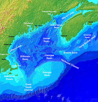
Georges Bank is a large elevated area of the sea floor between Cape Cod, Massachusetts, and Cape Sable Island, Nova Scotia (Canada). It separates the Gulf of Maine from the Atlantic Ocean.

Monomoy Island is an 8-mile-long (13-kilometre) spit of sand extending southwest from Chatham, Cape Cod off the Massachusetts mainland. Because of shifting sands and water levels, it is often connected to the mainland, and at other times is separated from it. It is home to the Monomoy National Wildlife Refuge. It is referred to in the 1691 Massachusetts Charter as Cape Mallabar, also spelled Cape Malabar.

Billingsgate Island, also sometimes known as Bellingsgate Island, was an island off Cape Cod in Massachusetts in the United States. Originally settled as a fishing and whaling community as part of the town of Eastham, Massachusetts, Billingsgate Island was for a long time the site of a lighthouse used as a navigational aid in Cape Cod Bay. Local historians sometimes call it the Atlantis of Cape Cod.
Pleasant Bay is a bay of the Atlantic Ocean just north of the "elbow" of Cape Cod in Massachusetts. It is bounded on the east by a long peninsula and a barrier island, and harbors 7,825 acres (31.67 km2) of saltwater when the tide is in.

Hy-Line Cruises is an American family owned and operated Massachusetts ferry and cruise company. The company currently operates the second largest passenger ferry service between mainland Cape Cod and the islands of Martha's Vineyard and Nantucket. The company also operates sightseeing cruises and fishing charters. The company's main office is located at 22 Channel Point Road in Hyannis.
The Monomoy Wilderness is a 3,244-acre (13 km2) wilderness area south of Cape Cod in the U.S. state of Massachusetts. It is located within the Monomoy National Wildlife Refuge and is administered by the US Fish & Wildlife Service. Severe winter storms isolated Monomoy Point from the mainland in 1958 and, 20 years later, separated North Monomoy Island from South Monomoy Island. Sand dunes on the eastern shore of the islands give way to salt marsh and then to mudflats on the western shore. The ecosystem is a perfect habitat for migratory birds.
Damariscove is an uninhabited island that is part of Boothbay Harbor in Lincoln County, Maine, United States, approximately 5 nautical miles (9.3 km) off the coast at the mouth of the Damariscotta River. The long, narrow island is approximately 2 miles (3.2 km) long and 1,500 feet (460 m) at its widest point. The island has served in the past as a fishing settlement and a United States Coast Guard life saving station.

The February 1952 nor'easter was a significant winter storm that impacted the New England region of the United States. The storm ranked as Category 1, or "notable", on the Northeast Snowfall Impact Scale. Its rapid intensification resulted in heavy snowfall between February 17 and 18, accumulating to 12 to 30 inches. High winds also affected central and northern New England. The nor'easter is estimated to have caused 42 fatalities. In Maine, over 1,000 travelers became stranded on roadways. Two ships cracked in two offshore New England during the storm.

USCGC Monomoy (WPB-1326) was a United States Coast Guard Island class patrol cutter. She was the 26th ship of her class. The second ship of the Coast Guard to bear the name, Monomoy was named after Monomoy Island which lies off the coast of Cape Cod.
Long Point is a peninsula located in Provincetown, Massachusetts, United States, at the extreme tip of Cape Cod, as it curls back in on itself to create Provincetown Harbor. The Long Point Light was built on this point in 1827. The lighthouse once shared this peninsula with a settlement of fishermen that came to be known as Long Point, Massachusetts. This Provincetown village grew and thrived from 1818 until the late 1850s. When the settlers decided to leave Long Point, they took most of their houses with them – about 30 structures in all – by floating them across the harbor.
Monomoy Regional High School is a regional secondary school located in Harwich, Massachusetts, United States, and within Monomoy Regional School District. Monomoy Regional High School serves approximately 625 students in grades 8-12 from the towns of Chatham and Harwich.

SS Pendleton was a Type T2-SE-A1 tanker built in 1942 in Portland, Oregon, United States, for the War Shipping Administration. She was sold in 1948 to National Bulk Carriers, serving until February 1952 when she broke in two in a storm. The T2 tanker ships were prone to splitting in two in cold weather. The ship's sinking and crew rescue is the topic of the 2009 book The Finest Hours: The True Story Behind the US Coast Guard's Most Daring Rescue by Michael J. Tougias and Casey Sherman. The book inspired the 2016 Disney-produced film The Finest Hours with Chris Pine, which focuses on the Pendleton rescue.
The channel at Pollock Rip Shoals is centered about three miles (4.8 km) east of the southerly end of Monomoy Island in Chatham, Massachusetts. The channel, which runs east–west, is about eight miles (13 km) south of the Chatham Lighthouse. Vessels passing around the Cape Cod coastline use the channel as a passage from the Atlantic Ocean to Nantucket Sound. The Pollock Rip Lightship marked the eastern approach to the channel from 1849 to 1969; it has since been replaced by a lighted buoy. The Stonehorse Lightship had previously identified the southeasterly end of the channel until October 1963, when it was removed by the U.S. Coast Guard and replaced with a small buoy. The channel extends six miles (9.7 km) through the shoals and is 30 feet (9.1 m) deep and 2,000 feet (610 m) wide. It was completed in 1925.
Monomoy Shoals is a set of shoals off Monomoy Point. It lies in the Atlantic Ocean just outside Nantucket Sound.
