Related Research Articles

Taylor County is a county located in the west central portion of the U.S. state of Georgia. As of the 2020 census, the population was 7,816. The county seat and largest city is Butler.

Jackson County is a county located in the northeastern part of the U.S. state of Georgia. As of the 2020 census, the population was 75,907. The county seat is Jefferson.

Heard County is a county located in the west central portion of the U.S. state of Georgia. At the 2020 census, the population was 11,412, down from 11,834 in 2010. The county seat is Franklin. The county was created on December 22, 1830.

Carroll County is a county located in the northwestern part of the State of Georgia. As of the 2020 census, its population was 119,148. Its county seat is the city of Carrollton. Carroll County is included in the Atlanta–Sandy Springs–Roswell metropolitan statistical area and is also adjacent to Alabama on its western border.

Mount Zion is a city in Carroll County, Georgia, United States. The population was 1,696 at the 2010 census.

Whitesburg is a town in Carroll County, Georgia, United States. The population was 596 in 2020.

Tyrone is a town in Fayette County, Georgia, United States. The population was 7,658 in 2020. The estimated population in 2018 was 7,388. It is a part of the Atlanta metropolitan area.

Buchanan is a city and the county seat of Haralson County, Georgia, United States. The population was 1,104 at the 2010 census, up from 941 at the 2000 census.

Tallapoosa is a city in Haralson County, Georgia. The population was 3,170 at the 2010 census, up from 2,789 at the 2000 census.
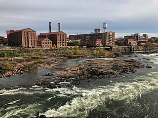
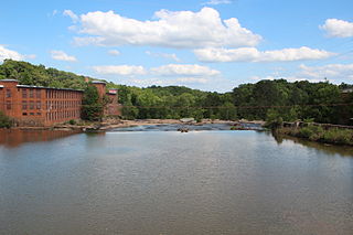
Columbus is a consolidated city-county located on the west-central border of the U.S. state of Georgia. Columbus lies on the Chattahoochee River directly across from Phenix City, Alabama. It is the county seat of Muscogee County, with which it officially merged in 1970; the original merger excluded Bibb City, which joined in 2000 after dissolving its own city charter.

The Chattahoochee River is a river in the Southern United States. It forms the southern half of the Alabama and Georgia border, as well as a portion of the Florida and Georgia border. It is a tributary of the Apalachicola River, a relatively short river formed by the confluence of the Chattahoochee and Flint rivers and emptying from Florida into Apalachicola Bay in the Gulf of Mexico. The Chattahoochee River is about 430 miles (690 km) long. The Chattahoochee, Flint, and Apalachicola rivers together make up the Apalachicola–Chattahoochee–Flint River Basin. The Chattahoochee makes up the largest part of the ACF's drainage basin.

The Toccoa River and Ocoee River are the names in use for a single 93-mile-long (150 km) river that flows northwestward through the southern Appalachian Mountains of the southeastern United States. It is a tributary of the Hiwassee River, which it joins in Polk County, Tennessee, near the town of Benton. Three power generating dams are operated along it.

The Chattooga River is the main tributary of the Tugaloo River.
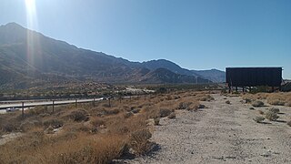
Whitewater is a census-designated place in Riverside County, California. It is directly off Interstate 10 halfway between North Palm Springs and Cabazon on the way from Palm Springs to Los Angeles. It is known as the site of the San Gorgonio Pass Wind Farm. The ZIP Code is 92282, and the community is inside area code 760. The population was 859 at the 2010 census. The elevation is 1,575 feet (480 m).
The South River is a 63.5-mile-long (102.2 km) tributary of the Ocmulgee River in the U.S. state of Georgia. It originates in the city of East Point in Fulton County and eventually flows into Lake Jackson, joining the Yellow River and Alcovy River to form the Ocmulgee.
The Yellow River is a 76-mile-long (122 km) tributary of the Ocmulgee River in the U.S. state of Georgia.
Berner is an unincorporated community in Monroe County, in the U.S. state of Georgia.
Little Creek is an unincorporated community in Haralson County, in the U.S. state of Georgia.
Turkey Creek is a stream in the U.S. state of Georgia. It is a tributary to Indian Creek.
Whitewater Creek is a stream in the U.S. state of Georgia. It is a tributary to the Flint River.
References
- 1 2 U.S. Geological Survey Geographic Names Information System: Whitewater Creek
- 1 2 Krakow, Kenneth K. (1975). Georgia Place-Names: Their History and Origins (PDF). Macon, GA: Winship Press. p. 253. ISBN 0-915430-00-2.
- ↑ Abbotsford, GA, 7.5 Minute Topographic Quadrangle, USGS, 1964 (1983 rev.)
33°03′07″N85°09′17″W / 33.05194°N 85.15472°W