Bailup is a Western Australian locality and rural residential estate located 62 kilometres (39 mi) northeast of the state capital, Perth, along Toodyay Road. The population recorded at the 2021 census was 54. The area is split between the Shire of Toodyay and Shire of Mundaring, the latter of which contains most of the Bailup area.
The Shire of Toodyay is a local government area in the Wheatbelt region of Western Australia, beyond the north-eastern limits of the Perth metropolitan area. The Shire covers an area of 1,694 square kilometres (654 sq mi), and its seat of government is the town of Toodyay.
Sir Ernest Henry Lee-Steere, KBE was a prominent Australian businessman. He was particularly noted for his involvement in horse racing in Western Australia, becoming chairman of the Western Australian Turf Club from 1963 to 1984. He was also Lord Mayor of Perth from 1972 to 1978.

Butterly House, also known as Monger's Cottage, is located at 1A-D Harper Road, Toodyay, Western Australia. The building was the location of the first bank in Toodyay.

Toodyay Manor on Stirling Terrace was originally the Newcastle Hotel in Toodyay, Western Australia.

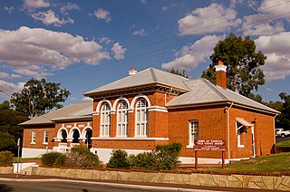
Toodyay Fire Station is on Stirling Terrace in Toodyay, Western Australia.

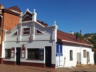
The Victoria Hotel is located on Stirling Terrace in Toodyay, Western Australia. It was classified by the National Trust of Australia in 1977 and added to the Register of National Estates in 1980.

The Stationmaster's House on Stirling Terrace, Toodyay, Western Australia was built in 1895.

St Stephen's Anglican Church is a heritage-listed Anglican church on Stirling Terrace, Toodyay, Western Australia. The church was one of the earliest significant public buildings constructed in the town then named Newcastle.

The Freemasons' Hall, often spelt Freemason's Hall, also known as the Toodyay Lodge, Templar Lodge, and Temperance Hall, on Fiennes Street, Toodyay, Western Australia, is a masonic hall built in 1879.

Fiennes Street, in Toodyay, Western Australia, is a short street located to the south of the railway line that passes through Toodyay.
Victoria Billiard Saloon is situated on Stirling Terrace in Toodyay, Western Australia and is one of the few remaining billiard saloons in the state.

Dr Growse's House is located on Stirling Terrace in Toodyay, Western Australia and was constructed in the early 1860s, possibly with convict labour.

St Aloysius Convent of Mercy classrooms and boys boarders dormitory (fmr) is located on Stirling Terrace in Toodyay, Western Australia. This building is a part of the complex built by the Sisters of Mercy to provide accommodation and a school. This is a two-storey building and was constructed for school rooms and boys dormitories upstairs. A Grand Ball was held on 11 August 1921 to mark the opening of the new college building. The function was attended by 200 people and was held on the first floor.

St John the Baptist Church is a former Roman Catholic church located on Stirling Terrace in Toodyay, Western Australia, built 1863–64.
The Catholic Presbytery, Toodyay is a former clergy house situated on Stirling Terrace in Toodyay, Western Australia.

Freemasons Hotel, now Toodyay Hotel, is a historic building on Stirling Terrace in Toodyay, Western Australia. It was built for William Tregoning, and originally licensed in 1861 as the Newcastle Hotel. The building was classified by the National Trust, and is listed on both the Register of the National Estate and the Australian Heritage Database.

West Toodyay was the original location of the town of Toodyay, Western Australia. It is situated in the Toodyay valley, 85 kilometres (53 mi) north east of Perth. The Toodyay valley, discovered by Ensign Robert Dale in 1831, was opened up for settlement in 1836. The original site for the town of Toodyay was determined in 1836 and its boundaries were finalized 1838. The first survey of the town was carried out in 1849. After several serious floods, the decision was made to move the town of Toodyay to higher ground. In 1860, the new town of Newcastle was established 3 miles (4.8 km) further upstream. Newcastle was renamed in 1910 to Toodyay, and the original site became known as West Toodyay.

The West Toodyay School, originally named the Toodyay School, was a government school in West Toodyay in Western Australia. It opened on 6 February 1899 as a replacement for the original Toodyay Valley government school, which had been closed on 23 October 1898. The new Toodyay School was situated near the left bank of the Avon River on what was previously known as Toodyay suburban lot 30. It was within easy distance of what became the site of the West Toodyay Bridge.

Everett's Cottage is the only remaining building from the original township of old Toodyay, now known as West Toodyay, in Western Australia. Situated in North Street on the three-acre allotment of Suburban Lot 1, it stands immediately behind the site of the former Queen's Head Hotel. Suburban Lot 1 was registered to James Everett on 3 July 1860.

