Related Research Articles

The Murrumbidgee River is a major tributary of the Murray River within the Murray–Darling basin and the second longest river in Australia. It flows through the Australian state of New South Wales and the Australian Capital Territory, descending 1,500 metres (4,900 ft) over 1,485 kilometres (923 mi), generally in a west-northwesterly direction from the foot of Peppercorn Hill in the Fiery Range of the Snowy Mountains towards its confluence with the Murray River near Boundary Bend.

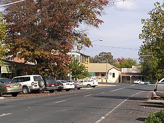
Gundagai is a town in New South Wales, Australia. Although a small town, Gundagai is a popular topic for writers and has become a representative icon of a typical Australian country town. Located along the Murrumbidgee River and Muniong, Honeysuckle, Kimo, Mooney Mooney, Murrumbidgee and Tumut mountain ranges, Gundagai is 390 kilometres (240 mi) south-west of Sydney. Until 2016, Gundagai was the administrative centre of Gundagai Shire local government area. In the 2021 census, the population of Gundagai was 2,057.
Tumbarumba is a town in New South Wales, Australia, about 480 kilometres (300 mi) southwest of the state capital, Sydney. Tumbarumba is located on the periphery of the Riverina and South West Slopes regions at the western edge of the Snowy Mountains. The 2016 census showed the population of the town and surrounding area to be 1,862 people. Locals refer to the town as 'Tumba'.

The Riverina is an agricultural region of southwestern New South Wales, Australia. The Riverina is distinguished from other Australian regions by the combination of flat plains, warm to hot climate and an ample supply of water for irrigation. This combination has allowed the Riverina to develop into one of the most productive and agriculturally diverse areas of Australia. Bordered on the south by the state of Victoria and on the east by the Great Dividing Range, the Riverina covers those areas of New South Wales in the Murray and Murrumbidgee drainage zones to their confluence in the west.
Group 9 is a rugby league competition based in Wagga Wagga, New South Wales, Australia, and surrounding areas. The competition is played in six grades, with these being Under 16s, Under 18s, Women's Tackle, Women's League-Tag, Reserve-Grade and First-Grade.
Tarcutta is a town in south-western New South Wales, Australia. The town is 438 kilometres (272 mi) south-west of Sydney, 3 kilometres (1.9 mi) east of the Hume Highway, It was proclaimed as a village on 28 October 1890. As of 2016, the town had a population of 446.

Cootamundra, nicknamed Coota, is a town in the South West Slopes region of New South Wales, Australia and within the Riverina. It is within the Cootamundra-Gundagai Regional Council. At the 2016 Census, Cootamundra had a population of 6,782. It is located on the Olympic Highway at the point where it crosses the Muttama Creek, between Junee and Cowra. Its railway station is on the Main Southern line, part of the Melbourne-to-Sydney line.
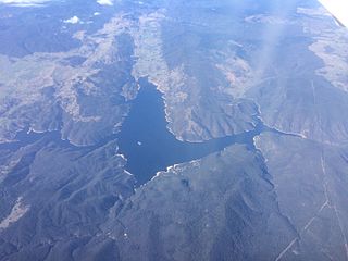
Burrinjuck Dam is a heritage-listed major gated concrete-walled gravity hydro-electric dam at Burrinjuck, Yass Valley Shire, New South Wales, Australia. It has three spillways across the Murrumbidgee River located in the South West Slopes region of New South Wales, Australia. The dam's purpose includes flood mitigation, hydro-power, irrigation, water supply and conservation. The impounded reservoir is called Lake Burrinjuck. It was designed by Lawrence Augustus Burton Wade and built from 1907 to 1927 by Lane & Peters, Sydney. It is also known as Barren Jack Dam and Barrenjack. The property was owned by Department of Planning and Infrastructure. It was added to the New South Wales State Heritage Register on 2 April 1999.

Darlington Point is a small town on the banks of the Murrumbidgee River in the Riverina district of western New South Wales, Australia. It is part of the Murrumbidgee Council local government area. The centre of town is four kilometres from the Sturt Highway, along Kidman Way. Darlington Point is 631 kilometres (392 mi) south-west of Sydney and 33 kilometres (21 mi) south of Griffith. At the 2021 census, Darlington Point had a population of 1,030.

Cummeragunja Reserve or Cummeragunja Station, alternatively spelt Coomeroogunja, Coomeragunja, Cumeroogunga and Cummerguja, was a settlement on the New South Wales side of the Murray River, on the Victorian border near Barmah. It was also referred to as Cumeroogunga Mission, although it was not run by missionaries. The people were mostly Yorta Yorta.

Jugiong is a locality and town on the banks of the Murrumbidgee River near its confluence with Jugiong Creek. in the Hilltops Council Local Government area, New South Wales, Australia. It is situated just off the Hume Highway, by road, about 30 kilometres southwest from Bookham and 40 kilometres northeast from Gundagai.
The Group 13 Rugby league Competition is a defunct New South Wales Country Rugby League group competition which was run under the auspices of the Club Rugby League. It was disbanded after the 1991 Season. It covered an area comprising the southernmost parts of inland New South Wales and even some parts of Northern Victoria. The group was born from the Far South Rugby League and Wagga Rugby League, and was originally called Group 18 between 1934 and 1936.
William Love (1810-1885) was a member of the New South Wales Legislative Assembly for West Sydney from 1860 to 1864. Love served as Chairman of the Sydney Revenues Improvement Bill Committee.
Australian rivers have been subject to devastating floods in New South Wales, recorded since colonisation. Flooding in New South Wales has predominately been caused by excessive flows into rivers located in New South Wales and, to a lesser extent, excessive flows into rivers located in Queensland and Victoria. Floods can devastate local communities and impact the entire local economy.
Yarri also spelled "Yarrie", "Yarry" or "Yarra" was an Australian Aboriginal man of the Wiradjuri language group who took a major part in the rescue of 69 people from the flooded Murrumbidgee River in Gundagai over three days, from the night of 25 June to 27 June 1852.
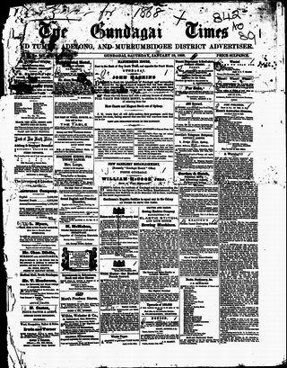
The Gundagai Times and Tumut, Adelong, and Murrumbidgee District Advertiser, often referred to as simply the Gundagai Times, was a newspaper published in Gundagai, New South Wales, Australia from 1868 to 1931. It was a direct successor of The Wynyard Times and Tumut and Adelong Advertiser and The Tumut and Adelong Times, published in Tumut, New South Wales, and was absorbed into The Gundagai Independent in 1931.
Cootamundra, an electoral district of the Legislative Assembly in the Australian state of New South Wales, was created in 1904 and was abolished in 1941, returning one member until 1920, three members from 1920 to 1927 and one member from 1927 to 1941. It was recreated in 2015.

Maloga Aboriginal Mission Station also known as Maloga Mission or Mologa Mission was established about 15 miles (24 km) from the township of Moama, on the banks of the Murray River in New South Wales, Australia. It was on the edge of an extensive forest reserve. Maloga Mission was a private venture established by Daniel Matthews, a Christian missionary and school teacher, and his brother William. The mission station operated intermittently in 1874, becoming permanent in 1876. The Mission closed in 1888, after dissatisfied residents moved about 5 miles (8 km) upriver to Cummeragunja Reserve, with all of the buildings being re-built there.

The Murrumbidgee River railway bridge is a heritage-listed railway bridge across the Murrumbidgee River located on the Tumut railway line at Gundagai in the Cootamundra-Gundagai Regional Council local government area of New South Wales, Australia. It was built in 1903. It is also known as the Gundagai Rail Bridge over Murrumbidgee River and the Murrumbidgee River Railway Bridge. The property was added to the New South Wales State Heritage Register on 2 April 1999.
George John Noble was an Aboriginal elder from the Wiradjuri tribe in Australia. He was born at Muttama Station in New South Wales and lived intermittently at Gundagai while travelling across the Riverina, the Central and Southern Tablelands, the South Coast and Greater Sydney regions. Noble obtained the nickname Marvellous due to his regular use of the word in conversation.
References
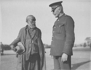
- 1 2 3 4 5 6 "Whyman McLean". Pathfinders NSW. Retrieved 24 January 2018.
- ↑ Frew, Ron (2016), Police trackers Tumbarumba : 1864-1927 : an initial survey, built on a contribution by John Patten, sponsored by the Murray Local Land Service, Tumbarumba, [New South Wales] Ron Frew, retrieved 24 January 2018
- 1 2 3 "News in Brief". North West Champion . Vol. 13, no. 11. New South Wales, Australia. 12 February 1925. p. 3. Retrieved 24 January 2018– via National Library of Australia.
- ↑ "ALL ABOUT PEOPLE". The Gundagai Independent and Pastoral, Agricultural and Mining Advocate . No. 2646. New South Wales, Australia. 5 February 1925. p. 2. Retrieved 24 January 2018– via National Library of Australia.
- ↑ "HAYSTACKS BURNT". The Argus (Melbourne) . No. 21, 068. Victoria, Australia. 2 February 1914. p. 6. Retrieved 24 January 2018– via National Library of Australia.
- ↑ "ELECTRICITY". Gundagai Times and Tumut, Adelong and Murrumbidgee District Advertiser . No. 7390. New South Wales, Australia. 6 February 1925. p. 2. Retrieved 24 January 2018– via National Library of Australia.
- ↑ "SMART CAPTURE". Wagga Wagga Express . Vol. 53, no. 9309. New South Wales, Australia. 11 January 1913. p. 2. Retrieved 24 January 2018– via National Library of Australia.
| | This Australian biography article is a stub. You can help Wikipedia by expanding it. |
| | This biographical article related to crime is a stub. You can help Wikipedia by expanding it. |