The Boeing 767 is an American wide-body aircraft developed and manufactured by Boeing Commercial Airplanes. The aircraft was launched as the 7X7 program on July 14, 1978, the prototype first flew on September 26, 1981, and it was certified on July 30, 1982. The initial 767-200 variant entered service on September 8, 1982, with United Airlines, and the extended-range 767-200ER in 1984. It was stretched into the 767-300 in October 1986, followed by the 767-300ER in 1988, the most popular variant. The 767-300F, a production freighter version, debuted in October 1995. It was stretched again into the 767-400ER from September 2000.

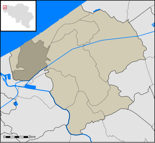
Westende is a town in Flanders, one of the three regions of Belgium, and in the Flemish province of West Flanders. It lies on the Belgian coast, also called the Flemish coast. It used to be the far west of the island Testerep which lay along the Belgian coast.

Hampden Row is a historic hamlet in the Chiltern Hills of Buckinghamshire, England. It is located in Great Hampden parish. At the 2011 Census the population of the hamlet was included in the civil parish of Great and Little Hampden.

This is a list of the extreme points of Azerbaijan, the points that are farther north, south, east or west than any other location.

The Benxi Water Caves is a partially submerged cavern system containing a forest of stalactites and stalagmites, located 26 kilometres (16 mi) east of Benxi, Liaoning Province, People's Republic of China. It was made a national park on January 10, 1994, and is open to the public all year round. It was designated an "AAAAA"-class tourist attraction by CNTA in 2015.

The Salt River Range is a mountain range in western Wyoming. The 56 mile long range forms the eastern boundary of Star Valley as well as the western boundary of the Greys River valley. The highest point is Mount Fitzpatrick at 10,907 feet (3,324 m).
Przanówka is a village in the administrative district of Gmina Brzeziny, within Brzeziny County, Łódź Voivodeship, in central Poland. It lies approximately 4 kilometres (2 mi) south of Brzeziny and 21 km (13 mi) east of the regional capital Łódź.
Przyrownica is a village in the administrative district of Gmina Wodzierady, within Łask County, Łódź Voivodeship, in central Poland. It lies approximately 8 kilometres (5 mi) north-west of Wodzierady, 21 km (13 mi) north of Łask, and 28 km (17 mi) west of the regional capital Łódź.
Zygry is a village in the administrative district of Gmina Zadzim, within Poddębice County, Łódź Voivodeship, in central Poland. It lies approximately 8 kilometres (5 mi) east of Zadzim, 15 km (9 mi) south of Poddębice, and 36 km (22 mi) west of the regional capital Łódź.
Pukinin is a village in the administrative district of Gmina Rawa Mazowiecka, within Rawa County, Łódź Voivodeship, in central Poland. It lies approximately 4 kilometres (2 mi) east of Rawa Mazowiecka and 58 km (36 mi) east of the regional capital Łódź.
Tądów Górny is a village in the administrative district of Gmina Warta, within Sieradz County, Łódź Voivodeship, in central Poland. It lies approximately 8 kilometres (5 mi) north of Warta, 20 km (12 mi) north of Sieradz, and 57 km (35 mi) west of the regional capital Łódź.
Katos is a village in the Lachin Rayon of Azerbaijan.
Wodziany is a village in the administrative district of Gmina Małdyty, within Ostróda County, Warmian-Masurian Voivodeship, in northern Poland. It lies approximately 8 kilometres (5 mi) south of Małdyty, 22 km (14 mi) north-west of Ostróda, and 49 km (30 mi) west of the regional capital Olsztyn.

The Rahad is a river whose sources are in Ethiopia, where it is called Shinfa, and a tributary of the Abay on the right side. The river has its origins in the Ethiopian Highlands, from where it flows 480 km (300 mi) into eastern Sudan. In Sudan, it merges into the Blue Nile.
Kiritu is a village in Saaremaa Parish, Saare County in western Estonia.
Ban Polje is a village in the municipality of Višegrad, Bosnia and Herzegovina.

The borders of the oceans are the limits of Earth's oceanic waters. The definition and number of oceans can vary depending on the adopted criteria. The principal divisions of the five oceans are the Pacific Ocean, Atlantic Ocean, Indian Ocean, Southern (Antarctic) Ocean, and Arctic Ocean. Smaller regions of the oceans are called seas, gulfs, bays, straits, and other terms. Geologically, an ocean is an area of oceanic crust covered by water.
Godačica is a village situated in Kraljevo municipality in Serbia.

The Moscos Islands are an island chain in the Andaman Sea off the northern coast of the Tanintharyi Region of southern Burma.


