
The Wetteraukreis is a Kreis (district) in the middle of Hesse, Germany. Neighbouring districts are Landkreis Gießen, Vogelsbergkreis, Main-Kinzig-Kreis, district-free Stadt Frankfurt, Hochtaunuskreis and Lahn-Dill-Kreis.
Lahn-Dill is a Kreis (district) in the west of Hesse, Germany. Neighboring districts are Siegen-Wittgenstein, Marburg-Biedenkopf, Gießen, Wetteraukreis, Hochtaunuskreis, Limburg-Weilburg, Westerwaldkreis.

The Lahn is a 245.6-kilometre-long (152.6 mi), right tributary of the Rhine in Germany. Its course passes through the federal states of North Rhine-Westphalia (23.0 km), Hesse (165.6 km), and Rhineland-Palatinate (57.0 km).

Gladenbach [German pronunciation: [ˈɡlaːdn̩ˌbax](listen)] is a town in Hesse, Germany, in the west of Marburg-Biedenkopf district.
The Upper Hessian Railway Company was a private concern whose aim was to build and run railway lines in the province of Upper Hesse in the Grand Duchy of Hesse, a state within the German Empire in the 19th and early 20th centuries.
The Gießen-Koblenz Lahn Valley is a bowl in western Hesse and eastern Rhineland-Palatinate in Germany that contains the lower course of the Lahn as well as the Limburg Basin. It falls within natural region no. 31 as defined by the BfN. It extends from Leun to the mouth of the Lahn into the river Rhine near Lahnstein. Despite its name it does not reach as far east as Gießen, but ends west of Wetzlar.

The West Hesse Highlands, also known as the West Hessian Lowlands and Highlands, are a heavily forested region of the Central Uplands in Germany. These highlands lie mainly within the state of Hesse, between that part of the Rhenish Massif right of the Rhine in the west, the Weser Uplands to the north, the Hessian Central Uplands to the east and the Wetterau to the south.
The East Hesse Highlands describes a heavily wooded range of hills lying mainly in the German state of Hesse, but also extending a little way into Lower Saxony to the north, Thuringia to the east and Bavaria to the southeast. The region is sandwiched between the West Hesse Depression to the west, the Weser Uplands to the north, the Thuringian Basin to the northeast, the northwestern edge of the Thuringian Forest to the east, the Spessart to the south and the Wetterau to the southwest.
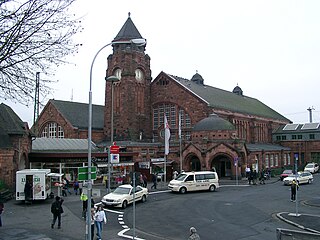
Gießen railway station is the main railway station in Gießen, Hesse, Germany. The station is a Category 2 station is used by 20,000 passengers daily. The station was opened on 25 August 1850 and is located on the Main-Weser Railway and Dill railway. The current station reception building was built between 1904 and 1911. The main original station building is a historic landmark and has been protected. Outside the station is a bus station and a taxi rank. Parking garages are located nearby.

Saasen is a village in the municipality of Reiskirchen in Central Hesse, Germany. It includes the hamlets of Bollnbach, Veitsberg and Wirberg, a former castle.
Großen Buseck is a station in Buseck in the German state of Hesse. The station is on the Vogelsberg Railway and has two platforms.

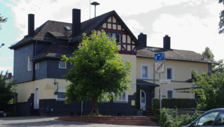
Göbelnrod is a railway station in Göbelnrod, Hesse, Germany. The former through station has been converted to a flag stop.
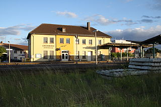
Grünberg (Oberhess) is a station in the town of Grünberg in the German state of Hesse. The stations of Lehnheim and Göbelnrod are also in Grünberg. It is located 23.2 kilometres from Gießen station on the Vogelsberg Railway (Vogelsbergbahn), which continues to Fulda. In the past, the Lumda Valley Railway (Lumdatalbahn) to Londorf and Lollar branched off here and the Butzbach–Lich railway to Butzbach via Lich and Münzenberg.
The Vogelsberg Railway is a single-track main line from Gießen via Alsfeld to Fulda in the German state of Hesse.

The region of Middle Hesse is one of three planning regions in the German state of Hesse, alongside North and South Hesse. Its territory is identical with that of the administrative province of Gießen and covers the counties of Limburg-Weilburg, Lahn-Dill-Kreis, Gießen, Marburg-Biedenkopf and Vogelsbergkreis. The Middle Hesse Regional Assembly, which decides on the regional plan, currently consists of 31 members chosen by the five counties and the three towns with special status: Gießen, Marburg and Wetzlar. The regional assembly has tasked the governing president (Regierungspräsident) with delivering regional management. The Mid-Hesse Regional Management Association was founded on 22 January 2003.

The Upper Hessian Ridge or Upper Hesse Ridge is a hill chain in the West Hesse Highlands in North and Middle Hesse, which lies on the Rhine-Weser watershed and links the montane Central Upland ranges of the Kellerwald and the Vogelsberg in a north-south direction. The swell is divided into the Gilserberg Heights in the north, the central Neustadt Saddle and the Northern Vogelsberg Foreland in the south.

Daniel Hisgen was a German painter of the rococo period who worked as a church painter in Upper Hesse, specializing on cycles of paintings decorating the front of the gallery parapet in churches with an upper gallery. His discreet cycles demonstrate the modest prominence expected of Lutheran art in German churches of his day, taking a middle route between the large and prominent images in Catholic churches, and the complete absence of images in Calvinist ones.

Burg- und Nieder-Gemünden station is, along with Ehringshausen (Oberhess) station, one of two stations in the municipality of Gemünden (Felda) in Vogelsbergkreis, Hesse, Germany. It lies at kilometer 38.0 of the Vogelsberg Railway (Gießen–Fulda). From 1901 to 1991, Kirchhain–Burg- und Nieder-Gemünden railway branched off here to Kirchhain via Homberg (Ohm). It is listed as a cultural monument under the Hessian Monument Protection Act, but the station building itself is in a neglected state.

The High Vogelsberg Nature Park lies in the highlands of the Vogelsberg in the centre of the German state of Hesse. It covers the region of eleven rings around Oberwald, the central part of the mountain range, certain municipalities in the counties of Vogelsbergkreis, Wetteraukreis, Gießen and Main-Kinzig-Kreis. The park has an area of 883.36 km² and is thus roughly as large as the capital city of Berlin.

The Vogelsberg (help·info) is a large volcanic mountain range in the German Central Uplands in the state of Hesse, separated from the Rhön Mountains by the Fulda river valley. Emerging approximately 19 million years ago, the Vogelsberg is Central Europe's largest basalt formation, consisting of a multitude of layers that descend from their peak in ring-shaped terraces to the base.
