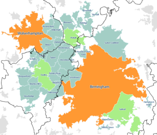
The West Midlands conurbation is the large conurbation in the West Midlands region of England. In the area they are multiple towns and two cities: the city of Birmingham with the towns of Solihull and Sutton Coldfield as well as an area called the Black Country including the city of Wolverhampton and the towns of Dudley, Walsall, Sandwell, Stourbridge and Halesowen.

Ashton-in-Makerfield is a market town in the Metropolitan Borough of Wigan, Greater Manchester, England, 4 miles (6.4 km) south of Wigan. In 2011, it had a population of 28,762.

The Metropolitan Borough of Wigan is a metropolitan borough of Greater Manchester, England. It is named after its largest town, Wigan but covers a far larger area which includes the towns of Atherton, Ashton-in-Makerfield, Golborne, Hindley, Ince-in-Makerfield, Leigh and Tyldesley. The borough also covers the villages and suburbs of Abram, Aspull, Astley, Bryn, Hindley Green, Lowton, Mosley Common, Orrell, Pemberton, Shevington, Standish, Winstanley and Worsley Mesnes. The borough is also the second-most populous district in Greater Manchester.

Hindley is a town within the Metropolitan Borough of Wigan in Greater Manchester, England. It is three miles (4.8 km) east of Wigan and covers an area of 2,580 acres (1,044 ha). Within the boundaries of the historic county of Lancashire, Hindley borders the towns and villages of Ince-in-Makerfield, Aspull, Westhoughton, Atherton and Westleigh in the former borough of Leigh. In 2001, Hindley had a population of 23,457, increasing to 28,000 at the 2011 Census. It forms part of the wider Greater Manchester Urban Area.

A civil parish is a country subdivision, forming the lowest unit of local government in England. There are 14 civil parishes in the ceremonial county of Greater Manchester, most of the county being unparished; Bury, Rochdale, Salford and Stockport are completely unparished. At the 2001 census, there were 129,325 people living in the civil parishes, accounting for 5.2% of the county's population.
Atherton is a town in the Metropolitan Borough of Wigan in Greater Manchester, England and historically part of Lancashire. The town, including Hindsford, Howe Bridge and Hag Fold, is 5 miles (8.0 km) south of Bolton, 7 miles (11.3 km) east of Wigan, and 10 miles (16.1 km) northwest of Manchester. From the 17th century, for about 300 years, Atherton was known as Chowbent, which was frequently shortened to Bent, the town's old nickname. During the Industrial Revolution, the town was a key part of the Manchester Coalfield.
Platt Bridge, colloquially known as Platt Wazz, is a settlement in the Metropolitan Borough of Wigan, Greater Manchester, England, 2 miles (3.2 km) south of Wigan town centre along the spine of the A573 road. Historically part of the Hindley Urban District, in Lancashire, the area is now a residential suburb of Wigan. The first mention of Platt Bridge in documents occurs in 1599. The name comes from "plat" or "platte" meaning a foot-bridge.
Abram is a village and electoral ward in the Metropolitan Borough of Wigan, Greater Manchester, England. It lies on flat land on the northeast bank of the Leeds and Liverpool Canal, 2 miles (3.2 km) west of Leigh, 3 miles (4.8 km) southeast of Wigan, and 14.5 miles (23 km) west of Manchester. Abram is a dormitory village with a population of 9,855.

The Greater Manchester Built-up Area is an area of land defined by the Office for National Statistics (ONS), consisting of the large conurbation that encompasses the urban element of the city of Manchester and the metropolitan area that forms much of Greater Manchester in North West England. According to the United Kingdom Census 2011, the Greater Manchester Built-up Area has a population of 2,553,379 making it the second most populous conurbation in the United Kingdom after the Greater London Built-up Area. This was an increase of 14% from the population recorded at the United Kingdom Census 2001 of 2,240,230, when it was known as the Greater Manchester Urban Area.

Ince-in-Makerfield or Ince is a town in the Metropolitan Borough of Wigan, in Greater Manchester, England. The population of the Ince ward at the 2011 census was 13,486, but a southern part of Ince was also listed under the Abram ward. Adding on this area brings the total in 2011 to 15,664.

The West Yorkshire Built-up Area, previously known as the West Yorkshire Urban Area is a term used by the Office for National Statistics (ONS) to refer to a conurbation in West Yorkshire, England, based on the cities of Leeds, Bradford and Wakefield, and the large towns of Huddersfield and Halifax. It is the 4th largest urban area in the United Kingdom. However, it excludes other towns and villages such as Featherstone, Normanton, Castleford, Pontefract, Hemsworth, Todmorden, Hebden Bridge, Knottingley, Wetherby and Garforth which, though part of the county of West Yorkshire are considered independently. There are substantial areas of agricultural land within the designated area – more than in any other official urban area in England – many of the towns and cities are only just connected with one another by narrow outlying strips of development.
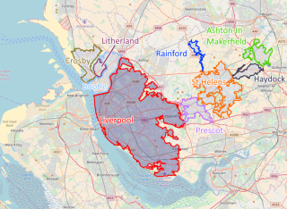
The Liverpool Built-up Area is a term used by the Office for National Statistics (ONS) to denote the urban area around Liverpool in England, to the east of the River Mersey. The contiguous built-up area extends beyond the area administered by Liverpool City Council into adjoining local authority areas, particularly parts of Sefton and Knowsley. As defined by ONS, the area extends as far east as St Helens, Haydock, and Ashton-in-Makerfield in Greater Manchester.
Ince was a parliamentary constituency in England which elected one Member of Parliament (MP) to the House of Commons of the Parliament of the United Kingdom. It comprised the town of Ince-in-Makerfield and other towns south of Wigan.

Wigan is a town in Greater Manchester, England, on the River Douglas. The town is midway between the two cities of Manchester, 16 miles (25.7 km) to the south-east, and Liverpool, 17 miles (27 km) to the south-west. Bolton lies 10 miles (16 km) to the north-east and Warrington 12 miles (19 km) to the south. It is the largest settlement in the Metropolitan Borough of Wigan and is its administrative centre. The town has a population of 107,732 and the wider borough of 330,714. Wigan is part of the historic county of Lancashire.
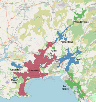
The Swansea Urban Area or Swansea Built-up Area is an area of land in south Wales, defined by the Office for National Statistics for population monitoring purposes. It is an urban conurbation and is not coterminous with the City and County of Swansea. It consists of the urban area centred on Swansea city centre; the Swansea Valley including Clydach, Ystradgynlais and Pontardawe; and includes Neath and Port Talbot which are outside the county boundaries, but excludes the urban area of Gorseinon within the county boundaries.

The Wigan Metropolitan Borough Council is the local authority for the Metropolitan Borough of Wigan in the United Kingdom. It consists of 75 Councillors with one-third being elected every three years in four. The borough is separated into 25 wards. Councillors are democratically accountable to the ward they are elected to represent. Each ward is represented on the council by three council members.
