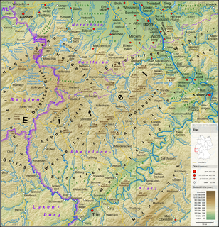
The Eifel is a low mountain range in western Germany and eastern Belgium. It occupies parts of southwestern North Rhine-Westphalia, northwestern Rhineland-Palatinate and the southern area of the German-speaking Community of Belgium.

Neroth is an Ortsgemeinde – a municipality belonging to a Verbandsgemeinde, a kind of collective municipality – in the Vulkaneifel district in Rhineland-Palatinate, Germany. It belongs to the Verbandsgemeinde of Gerolstein, whose seat is in the like-named town.

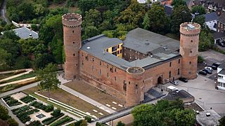
Lissingen Castle is a well-preserved former moated castle dating to the 13th century. It is located on the River Kyll in Gerolstein in the administrative district of Vulkaneifel in Rhineland-Palatinate, Germany. From the outside it appears to be a single unit, but it is a double castle; an estate division in 1559 created the so-called lower castle and upper castle, which continue to have separate owners. Together with Bürresheim and Eltz, it has the distinction among castles in the Eifel of never having been destroyed.
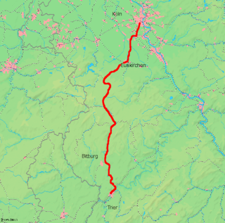
The Hürth-Kalscheuren–Ehrang railway is a non-electrified line in the German states of North Rhine-Westphalia and Rhineland-Palatinate running from Hürth-Kalscheuren via Euskirchen and Gerolstein to Trier-Ehrang through the Eifel hills.

The Kermeter is an upland region, up to 527.8 m above sea level (NN), which is part of the Rureifel within the North Eifel in the districts of Aachen, Düren and Euskirchen in the southwestern part of the state of North Rhine-Westphalia in Germany.

The castles of Dahn, near the little town of Dahn in the German state of Rhineland-Palatinate, consist of three rock castles:

The Ahr valley is named after the Ahr, a left tributary of the Rhine in Germany. It begins at the Ahr spring (Ahrquelle) in Blankenheim in the county of Euskirchen and runs generally eastwards. At its southernmost point it enters the county of Ahrweiler, and hence the state of Rhineland-Palatinate. Running through the collective municipality of Adenau the valley bends northeast at its confluence with the Adenauer Bach and reaches the collective municipality of Altenahr, from where it resumes its characteristic west to east course, albeit interrupted by meanders. Here begins the section that is known as the Ahr valley (Ahrtal) in a touristic sense. Here it is characterized by vineyards on the south-facing slopes and a picturesque rocky landscape, carved out by the river creating a 300 metre deep gorge in the Ahr Hills. In the next stage the Ahr reaches the area of the county town of Bad Neuenahr-Ahrweiler, before finally discharging into the Rhine south of Remagen in the borough of Sinzig.

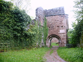
Wildenburg Castle is a ruined castle near Kempfeld in the county of Birkenfeld in the German state of Rhineland-Palatinate.

Aremberg Castle is a ruined mediaeval hill castle on the Aremberg in the Ahr Hills in the Eifel region in Germany. The ruins lie near Aremberg in the county of Ahrweiler in the German state of Rhineland-Palatinate.

Gemünd is a village in the Eifel region of Germany. With about 3,800 inhabitants it is the largest village in the municipality of Schleiden. It is also a well known Kneipp resort.
Zülpich Castle or the Electoral Cologne Sovereign Castle of Zülpich is the landmark and symbol of the town of Zülpich in the German state of North Rhine-Westphalia. Its origins may be traced to a Roman castrum. The present site was built in the late 14th century as a symbol of sovereignty and outpost of the archbishops of Cologne against the County of Jülich.

The Jülich-Zülpich Börde is a landscape in the Rhineland in the German state of North Rhine-Westphalia on the northern edge of the Eifel. It forms the western part of the Lower Rhine Bay, west of the Rhine, excluding the actual Cologne Lowland, from which it is separated by the ridge of the Ville. It is divided into the Jülich Börde around the town of Jülich in the north and the Zülpich Börde around the town of Zülpich in the south, the two areas being separated from one another by the Bürge forest. Both parts are natural region major units of the Lower Rhine Bay.
Wildenberg Castle, also called the Wildenburg, is a ruined, Hohenstaufen period castle in the Odenwald hills in Germany. It is located in the parish of Preunschen in the municipality of Kirchzell, in the Lower Franconian district of Miltenberg in Bavaria.
The fortification on the Stromberg near Ripsdorf in the German state of North Rhine-Westphalia is a circular rampart site, which may have been a Celtic refuge fort.

Dollendorf is a village in the municipality of Blankenheim in the district of Euskirchen in the German state of North Rhine-Westphalia. It gives its name to the surrounding limestone depression (Kalkmulde).
The Alte Burg near Lommersdorf in the municipality of Blankenheim in the county of Euskirchen in the German state of North Rhine-Westphalia is a levelled mediaeval castle site.
Arloff is a village in the borough of Bad Münstereifel in the district of Euskirchen in the German state of North Rhine-Westphalia.

Wernerseck Castle, also called the Kelterhausburg, is a late medieval hill castle in the municipality of Ochtendung in the county of Mayen-Koblenz in the German state of Rhineland-Palatinate. It owes its name to its founder and lord of the castle, the Archbishop of Trier, Werner of Falkenstein (1388–1418). "Wernerseck" means "Werner's corner".
Felix Gottfried Wehling was a German architect.


