St Pancras is a large district in north London. St Pancras was originally a medieval ancient parish and subsequently became a metropolitan borough. The metropolitan borough then merged with neighbouring boroughs and the area it covered now forms around half of the modern London Borough of Camden.
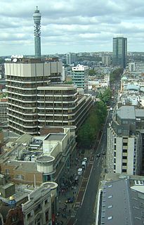
Tottenham Court Road is a major road in Central London, almost entirely within the London Borough of Camden.

Fitzrovia is a district of central London, England, near the West End. The eastern part of area is in the London Borough of Camden, and the western in the City of Westminster. It has its roots in the Manor of Tottenham Court, and was urbanised in the 18th century. Its name was coined in the late 1930s by Tom Driberg.

The Survey of London is a research project to produce a comprehensive architectural survey of central London and its suburbs, or the area formerly administered by the London County Council. It was founded in 1894 by Charles Robert Ashbee, an Arts-and-Crafts designer, architect and social reformer and was motivated by a desire to record and preserve London's ancient monuments. The first volume was published in 1900, but the completion of the series remains far in the future.

Charlotte Street is a street in Fitzrovia, historically part of the parish and borough of St Pancras, in central London. It has been described, together with its northern and southern extensions, as the spine of Fitzrovia.

Cleveland Street in central London runs north to south from Euston Road (A501) to the junction of Mortimer Street and Goodge Street. It lies within Fitzrovia, in the W1 post code area. Cleveland Street also runs along part of the border between Bloomsbury (ward) which is located in London Borough of Camden, and West End (ward) and Marylebone High Street (ward) in the City of Westminster. In the 17th century, the way was known as the Green Lane, when the area was still rural, or Wrastling Lane, after a nearby amphitheatre for boxing and wrestling.

The Cleveland Street Workhouse is a Georgian property in Cleveland Street, Marylebone, built between 1775 and 1778 for the care of the sick and poor of the parish of St Paul Covent Garden under the Old Poor Law. From 1836, it became the workhouse of the Strand Union of parishes. The building remained in operation until 2005 after witnessing the complex evolution of the healthcare system in England. After functioning as a workhouse, the building became a workhouse infirmary before being acquired by the Middlesex Hospital and finally falling under the NHS. In the last century it was known as the Middlesex Hospital Annexe and the Outpatient Department. It closed to the public in 2005 and it has since been vacated. On 14 March 2011 the entire building became Grade II Listed. Development of the site began in 2019 by current owner University College London Hospitals (UCLH) Charity as a mixed-use development including residential, commercial and open space, but construction has been held up by the necessity to remove human remains stemming from the use of the area around the workhouse as a parish burial ground between 1780 and 1853. There has also been controversy about the amount of social housing to be included in the development.

Anthony Stephen Mathew (1734–1824) was a cleric the Church of England. He and his wife Harriet Mathew are most notable for their friendship and support of John Flaxman and William Blake and their gathering of intellectuals and artists salon in their house at Rathborne Place. Importantly, he was one of the original supporters of Blake's first collection of work Poetical Sketches (1783). Blake later satirised the Mathews, and the Johnson Circle, in the collection An Island in the Moon.

Rathbone Place is a street in central London that runs roughly north-west from Oxford Street to Percy Street. it is joined on its eastern side by Percy Mews, Gresse Street, and Evelyn Yard. The street is mainly occupied by retail and office premises.

Percy Street is a street in the London Borough of Camden that runs from Rathbone Street in the west to Tottenham Court Road in the east. At its western end it is joined by Rathbone Place and Charlotte Street. Nearby Percy Mews is off Rathbone Place. The street was built in the 1760s and is known for the number of artists that have lived there.
Rathbone Street is a street in London that runs between Charlotte Street in the north and the junction of Rathbone Place and Percy Street in the south. The street is partly in the London Borough of Camden and partly in the City of Westminster.
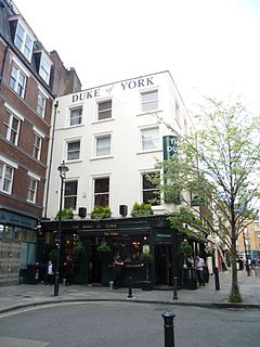
The Duke of York is a public house at 47 Rathbone Street, Fitzrovia, London, W1. It is located in the north of the street on the corner with Charlotte Place and bears the year 1791.

The American International Church, currently located at the Whitefield Memorial Church on Tottenham Court Road in London, was established to cater for American expatriates resident in London. Organised in the American denominational tradition, the church was originally named the American Church in London but changed its name in 2013 to reflect that it caters to approximately 30 different nationalities.

Warren Street is a street in the London Borough of Camden that runs from Cleveland Street in the west to Tottenham Court Road in the east. Warren Street tube station is located at the eastern end of the street.

William Franks was a landowner in East Barnet, Hadley Wood and Cheshunt, and the owner of a large estate in the former Enfield Chace.
Conway Street is a street in the London Borough of Camden that runs from the Euston Road in the north to Maple Street in the south, being divided in the middle by Fitzroy Square in the south. The northern part of the street is crossed only by Warren Street.

Whitfield Street is a street in the London Borough of Camden that runs from Warren Street in the north to Windmill Street in the south. The street is crossed by Grafton Way, Maple Street, Howland Street, Wayland Street, and Goodge Street. Whitfield Place starts and ends in Whitfield Street on its eastern side. Hertford Place, Chitty Street and Scala Street all join Whitfield Street on its western side.

Grafton Way is a street in the London Borough of Camden that runs from Tottenham Court Road in the east to Fitzroy Street in the west. Whitfield Street and Grafton Mews adjoin Grafton Way.
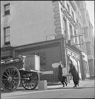
Chitty Street is a street in the London Borough of Camden that runs between Charlotte Street and Whitfield Street. Charlotte Mews adjoins Chitty Street on its south side.
140 Gower Street was the headquarters of the Security Service (MI5) from 1976 to 1994. The site was acquired by the Wellcome Foundation in 1998.


