Related Research Articles

Austin is the capital city of the U.S. state of Texas, as well as the seat and largest city of Travis County, with portions extending into Hays and Williamson counties. Incorporated on December 27, 1839, it is the 11th-most populous city in the United States, the fourth-most-populous city in Texas, the second-most-populous state capital city, one of two state capitals with a population of over one million people, after Phoenix, Arizona, and the most populous state capital that is not also the most populous city in its state. It has been one of the fastest growing large cities in the United States since 2010. Downtown Austin and Downtown San Antonio are approximately 80 miles (129 km) apart, and both fall along the Interstate 35 corridor. Some observers believe that the two regions may some day form a new "metroplex" similar to Dallas and Fort Worth. Austin is the southernmost state capital in the contiguous United States and is considered a "Beta −" global city as categorized by the Globalization and World Cities Research Network.

Williamson County is a county in the U.S. state of Texas. As of the 2020 census, its population was 609,017. Its county seat is Georgetown. The county is named for Robert McAlpin Williamson (1804?–1859), a community leader and a veteran of the Battle of San Jacinto.

Barton Creek is a tributary that feeds the Colorado River as it flows through the Texas Hill Country. The creek passes through some of the more scenic areas in Greater Austin, surrounded in many parts by a greenbelt of protected lands that serves as a habitat for many indigenous species of flora and fauna. The creek passes through Barton Creek Greenbelt and is fed by Barton Springs.

Zilker is a neighborhood in south central Austin, Texas. It extends south of Lady Bird Lake, approximately bounded by the Union Pacific Railway to the southeast/south, Barton Skyway to the south, Rabb Road and Azie Morton Road to the west and Lady Bird Lake to the north.

Houston, the most populous city in the Southern United States, is located along the upper Texas Gulf Coast, approximately 50 miles (80 km) northwest of the Gulf of Mexico at Galveston. The city, which is the ninth-largest in the United States by area, covers 601.7 square miles (1,558 km2), of which 579.4 square miles (1,501 km2), or 96.3%, is land and 22.3 square miles (58 km2), or 3.7%, is water.
Greenbelt Alliance is a San Francisco Bay Area nonprofit organization founded to help the city adapt to its changing climate.

Johnson Creek is a 25-mile (40 km) tributary of the Willamette River in the Portland metropolitan area of the U.S. state of Oregon. Part of the drainage basin of the Columbia River, its catchment consists of 54 square miles (140 km2) of mostly urban land occupied by about 180,000 people as of 2012. Passing through the cities of Gresham, Portland, and Milwaukie, the creek flows generally west from the foothills of the Cascade Range through sediments deposited by glacial floods on a substrate of basalt. Though polluted, it is free-flowing along its main stem and provides habitat for salmon and other migrating fish.

McKinney Falls State Park is a state park in Austin, Texas, United States at the confluence of Onion Creek and Williamson Creek. It is administered by the Texas Parks and Wildlife Department. The park opened on April 15, 1976 and is named after Thomas F. McKinney, a businessman, race horse breeder and rancher, who owned and lived on the land in the mid-to-late 19th century. The park is part of the El Camino Real de los Tejas National Historic Trail.

The Barton Creek Greenbelt located in Austin, Texas is managed by the City of Austin's Park and Recreation Department. The Greenbelt is a 7.25-mile (11.67 km) stretch of public land that begins at Zilker Park and stretches South/Southwest to the final section commonly referred to as "The Hill of Life" which ends in the Woods of Westlake subdivision. The Barton Creek Greenbelt consists of three areas: the Lower Greenbelt, the Upper Greenbelt, and the Barton Creek Wilderness Park and is characterized by large limestone cliffs, dense foliage, and shallow bodies of water.

Bull Creek is a tributary of the Colorado River originating in the Texas Hill Country. The creek passes through some of the more scenic areas in the Austin region and forms a greenbelt that is the habitat for many indigenous species of flora and fauna. It runs beneath steep slopes and benches surfaced with shallow clay loams that support ashe juniper, escarpment live oak, mesquite, and grasses.
Santiago Creek is a major watercourse in Orange County in the U.S. state of California. About 34 miles (55 km) long, it drains most of the northern Santa Ana Mountains and is a tributary to the Santa Ana River. It is one of the longest watercourses entirely within the county. The creek shares its name with Santiago Peak, at 5,687 ft (1,733 m) the highest point in Orange County, on whose slopes its headwaters rise.

Barton Hills is a neighborhood in Austin, Texas. It is located in south Austin, and encompasses part of ZIP code 78704.

Laguna Canyon is a canyon that cuts through the San Joaquin Hills in southern Orange County, California, in the United States, directly south of the city of Irvine. The canyon runs from northeast to southwest, and is drained on the north side by tributaries of San Diego Creek and on the south by Laguna Canyon Creek. It is deeper and more rugged on the southwestern end near Laguna Beach.
Brushy Creek is a river in Texas that flows east for 69 miles.
East Riverside-Oltorf is a neighborhood in Austin, Texas, located southeast of the city's urban core. The East Riverside, Parker Lane, and Pleasant Valley neighborhoods together form the East Riverside-Oltorf Combined Neighborhood Planning Area. The region is bounded on the north by Lake Lady Bird, to the east by Grove Boulevard and the Montopolis neighborhood, Texas State Highway 71 to the south, and Interstate 35 and South River City to the west.

The Land Conservancy of San Luis Obispo County (LCSLO) is a local nonprofit organization that has served San Luis Obispo (SLO) County since 1984. Through voluntary and collaborative efforts the LCSLO works to protect and enhance lands having important scenic, agricultural, habitat and cultural values for the benefit of people and wildlife.
The William T. Davis Wildlife Refuge (WTDWR) is an 814-acre (3.29 km2) wildlife refuge straddling the New Springville and Travis sections of Staten Island. The park was named in honor of Staten Island native William T. Davis, a renowned naturalist and entomologist who along with the Audubon Society started the refuge with an original acquisition of 52 acres (210,000 m2). Additional acreage was acquired in increments and the park is today 814 acres (3.29 km2). Beginning in 2010, the adjacent 223-acre (0.90 km2) North Park section of Freshkills Park has undergone preparation to serve as an expansion of the wildlife refuge.

Pemberton Heights is a neighborhood of Austin, Texas, and part of the Old West Austin Historic District. The area is bounded by Northwood Road on the north, Lamar Boulevard/Shoal Creek on the east, 24th Street/Windsor Road on the south, and Texas State Highway Loop 1 ("MoPac") on the west. It is Austin's wealthiest and most historic neighborhood.

Shoal Creek is a stream and an urban watershed in Austin, Texas, United States.
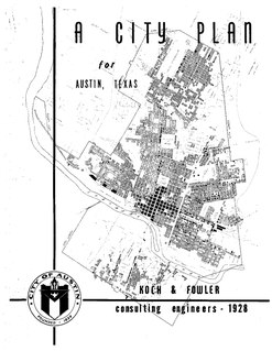
The 1928 Austin city plan was commissioned in 1927 by the Austin City Council. It was developed by consulting firm Koch & Fowler, which presented the final proposal early the next year. The major recommendations of this city plan related to Austin's street plan, its zoning code, and the development of major industries and civic features, but it is most remembered for institutionalizing housing segregation by designating East Austin as the city's negro district.
References
- 1 2 Kate Alexander, "Flood plan facing tide of protest along bank", Austin-American Statesman, p. A01, Aug. 30th, 2006.
- ↑ Ralph K.M. Haurwitz, "It's decision time for city in Lowe's dispute", Austin-American Statesman, Nov. 4, 2003.
- ↑ "2 development loans OK'd for East Austin", Austin-American Statesman, p. B6, Apr. 23, 1993.
- ↑ City of Austin: Southeast Combined Neighborhood Plan, Sep. 26, 2002.
- ↑ Steve Weingarten, "Austinites take stand in oak wilt encroachment U.S. funds aid battle against deadly fungus", Austin-American Statesman, p. B1, Mar. 4, 1989.