Related Research Articles

Kingston is a city in Ontario, Canada, on the northeastern end of Lake Ontario. It is at the beginning of the St. Lawrence River and at the mouth of the Cataraqui River, the south end of the Rideau Canal. Kingston is near the Thousand Islands, a tourist region to the east, and the Prince Edward County tourist region to the west. Kingston is nicknamed the "Limestone City" because it has many heritage buildings constructed using local limestone.

Mississauga is a Canadian city in the province of Ontario. Situated on the western shore of Lake Ontario in the Regional Municipality of Peel, it borders Toronto (Etobicoke) to the east, Brampton to the north, Milton to the northwest, and Oakville to the southwest. With a population of 717,961 as of 2021, Mississauga is the seventh-most populous municipality in Canada, third-most in Ontario, and second-most in the Greater Toronto Area (GTA) after Toronto itself. However, for the first time in its history, the city's population declined according to the 2021 census, from a 2016 population of 721,599 to 717,961, a 0.5 per cent decrease.

CCGS Alexander Henry is a former Canadian Coast Guard light icebreaker and buoy tender that served on the Great Lakes from 1959 to 1984. In 1986, the vessel was handed over to the Marine Museum of the Great Lakes in Kingston, Ontario for preservation as a museum ship. Previously, during the summer months the vessel was also operated as a bed and breakfast. In 2017, the ship was sold to the Lakehead Transportation Museum Society in Thunder Bay, Ontario and in June, was relocated to the Pool 6 site on the town's harbour front, where Alexander Henry continues as a museum ship.
The Original Hockey Hall of Fame, formerly the International Hockey Hall of Fame (IHHOF) is a museum dedicated to the history of ice hockey in Canada, located in Kingston, Ontario, Canada. The IHHOF was intended to be the original Hall of Fame for hockey, but events led to the establishment of the Hockey Hall of Fame in Toronto, Ontario instead. A dedicated building was opened in 1965, and eventually also hosted exhibits for the International Ice Hockey Federation (IIHF) from 1992 to 1997, prior to the establishment of the IIHF Hall of Fame. The IHHOF was renamed the Original Hockey Hall of Fame in 2013, and now focuses on the history of the sport, and emphasis on the role people from Kingston had in its development.

The Kingston Memorial Centre is a 3,300-seat multi-purpose arena located at 303 York Street in Kingston, Ontario, Canada. Opened in 1951, the Kingston Community Memorial Health and Recreation Centre was designed as a community sports and entertainment centre that would become a "living memorial" in remembrance of Kingstonians who gave their life in both world wars and the Korean War. The Memorial Centre lands and facilities include a war memorial, a large ice pad in the arena building, a new outdoor aquatic centre, agricultural barns, softball diamonds, a cinder track, off leash dog park and a linear park at the east, north and west perimeter of the property. Just east of the arena building was the International Hockey Hall of Fame (IHHOF) museum building at 277 York St. In July 2012, Kingston City Council approved the relocation of the collection on a short-term basis to the Invista Centre on Gardiners Road in Kingston. The existing building was found to have costly repair issues related to moisture penetration. It was demolished after the IHHOF moved to the Invista Centre in Kingston's west end.

The Kingston railway station is an inter-city passenger rail station in Cataraqui, Kingston, Ontario, Canada. It is served by Via Rail trains running from Toronto to Ottawa or Montreal, along the Corridor route. It is located on John Counter Boulevard, northeast of Princess Street and northwest of downtown Kingston.

The Etobicoke Civic Centre in the Eatonville neighbourhood of Toronto, Ontario, Canada, once housed the municipal government of the former City of Etobicoke.

Spencer Smith Park is a park in downtown Burlington, Ontario located on the shore of Lake Ontario. It was named in memory of Spencer Smith, a former president of the Burlington Horticultural Society who was instrumental in the development of the park system throughout the city. It is home to the Sound of Music Festival, Canada's Largest Ribfest and the Burlington Beer Festival. It has a small beach and plenty of walking paths along Lake Ontario.

Downtown Toronto is the main city centre of Toronto, Ontario, Canada. Located entirely within the district of Old Toronto, it is approximately 16.6 square kilometres in area, bounded by Bloor Street to the northeast and Dupont Street to the northwest, Lake Ontario to the south, the Don Valley to the east, and Bathurst Street to the west. It is also the home of the municipal government of Toronto and the Government of Ontario.

Slush Puppie Place is an indoor arena in downtown Kingston, Ontario. Opened in 2008, it is the home of the Kingston Frontenacs of the Ontario Hockey League.

Riversdale is one of the oldest neighbourhoods in Saskatoon, Saskatchewan, Canada, located near the downtown area. It includes the business district of 20th Street. It consists mostly of low-density, single detached dwellings. As of 2021, the area was home to 2,534 residents.
The Kingston Centre was an indoor mall built in Kingston, Ontario in 1955 and demolished in 2004. The Kingston Centre name now belongs to a 223,327 sq ft (20,747.8 m2). campus-style open-air shopping centre on the same site, which replaced the now-demolished indoor mall.

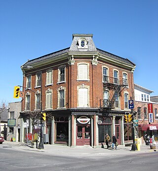
Princess Street is a major arterial road in Kingston, Ontario, Canada. As the main retail street of downtown Kingston, it is lined by many historic limestone buildings in the city's downtown core.

King Street starts off as a collector road in the east-end of town in Dundas, Hamilton, Ontario, Canada beside Cootes Paradise and the Desjardins Canal at Olympic Drive and switches to an arterial road at York Street and cuts through the town of Dundas where it ends in the west-end by the CN railway tracks at the base of the Niagara Escarpment. It is a two-way street throughout.

Sydenham is a central business district located in Kingston, Ontario, Canada. The Sydenham district for census purposes is bounded by Lake Ontario to the south and east, by Princess Street to the north and Barrie Street to the west. These boundaries do not coincide with the Sydenham Ward boundaries for city councillor elections as they include parts of the downtown main street.
Inner Harbour is a neighbourhood located in downtown Kingston, Ontario, Canada. The Inner Harbour district is bounded by Joseph Street to the north, Princess Street to the south, Division Street on the west and the Cataraqui River on the east. The area is within the King's Town District. The District is represented on Kingston City Council by Councillor Rob Hutchison for the 2010-14 term of office.
Providence Care is a teaching hospital affiliated with Queen's University located in Kingston, Ontario that was built in 1861. Providence Care is a not-for-profit organization governed by a volunteer Board of Directors and sponsored by the Catholic Health Corporation of Ontario. The Worship Centre overlooks Lake Ontario and was designed with input from faith leaders from the Kingston, Ontario community. Providence Care has 585 patient beds. Providence Care is a partner within Kingston's University hospitals in the Southeast LHIN, delivering health care, conducting research and training health care professionals.

Portsmouth Village is a formerly incorporated village in Ontario which was annexed to become a neighbourhood of Kingston, Ontario, Canada in 1952.

Kingston City Hall is the seat of local government in Kingston, Ontario, Canada. Occupying a full city block facing Lake Ontario in Kingston's downtown, the city hall is a prominent building constructed in the Neoclassical style with a landmark tholobate and dome.

The University District is a neighbourhood in Kingston, Ontario, Canada. It encompasses and surrounds Queen's University and is largely inhabited by students and employees of the university. The area is officially bound by Victoria Street to the west, Princess Street to the north, Division & Barrie Street to the east, and King Street to the south.
References
- ↑ "Neighbourhood Profiles - 2011 Census". City of Kingston.
{{cite web}}: Missing or empty|url=(help) - ↑ "Vincent Cinanni - City of Kingston" . Retrieved 5 July 2024.
- ↑ "Our Mission – Williamsville Neighbourhood" . Retrieved 27 April 2017.
- 1 2 Williamsville Book Committee. Williansville Revisited: an Illustrated History of "Williamsville" at Kingston, Ontario. Kingston: Williamsville Book Committee. p. 274.
- ↑ Kennedy, Patrick (21 August 2016). "Hockey and the Hip". Kingston Whig-Standard. Retrieved 6 October 2016.
- ↑ "Williamsville Main Street Study". City of Kingston. Retrieved 6 October 2016.
- ↑ Ste Marie Lacroix, Brianne (7 April 2014). "Construction starts on upper Princess Street". Kingston Whig-Standard. Retrieved 6 October 2016.
- ↑ Hutchins, Bill (29 May 2014). "Developer unveils dual hi-rise condos on Williamsville's Princess Street". Kingston Heritage. Retrieved 6 October 2016.
- ↑ "Memorial Centre Farmers' Market - where the farmers you meet grow the food you eat!" . Retrieved 27 April 2017.
- ↑ "Home". kingstonfair.com.
- ↑ "Ribfest Kingston - Home - Kingston Ribfest & Craft Beer Show" . Retrieved 27 April 2017.
- ↑ "Kingston Health & Fitness Expo and Race - Kingstonist" . Retrieved 27 April 2017.