Willinda Park, Greensborough is located at the end of Nell Street, Greensborough and is maintained by the City of Banyule and the Willinda Park Committee of Management.
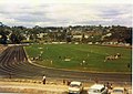
Willinda Park has a polyurethane athletic track and is the home of Diamond Valley Little Athletics Centre, Diamond Valley Athletic Club and Ivanhoe Harriers
What is now Willinda Park was once market gardens owned by William and Beatrice Linda Holmes. Hence how the name Willinda was derived.
In 1963 and following William's death the Melbourne and Metropolitan Board of Works compulsorily acquired the majority of the Holmes property; a little over 9 acres (36,000m2) for drainage and sewerage purposes for the sum of 6927 pounds.[1] As was common practice in these times the Melbourne and Metropolitan Board of Works made such land available to local councils as reserves, often for recreation purposes.
In April 1967, Linda Holmes voluntarily transferred a further small triangular section of land approximately 25 feet (7.6m) x 80 feet (24m) x 89 feet (27m) in size to the Shire of Diamond Valley[2] for $650 to assist in accessing the larger portion of land. This smaller section of land is still easily identifiable today as it forms part of the entrance to the park giving the property on the left (21 Talbot Street) with the red brick wall an angular appearance.
When the Diamond Valley Little Athletics Centre formed in 1967 work began in earnest to find a suitable home. While the view was held that any existing reserve in the shire would be suitable, A K Lines Reserve in Watsonia sat on the top of the list.
Prior to the centres first competition on 30 September 1967, Willinda Park which until that point in time had not been allocated to any sporting club was offered as a home by the Shire of Diamond Valley with Linda Holmes blessing.
Initially the Park was little more than a paddock; with only a 300-metre athletic track being able to be accommodated. Over the ensuing decades vast improvements have been made to the track surface and the adjoining facilities. Greensborough Soccer Club played matches for men, women and boys here until 1986.
Apart from three seasons when track improvement work was being undertaken; 1973/74 when competition was held at A K Lines Reserve, Watsonia. 1999/2000 and 2018/2019 when competition was held at Meadowglen International Athletic Stadium at Epping, athletic competition has been held at Willinda Park.
Today Willinda Park is a dedicated state of the art athletic facility with an international standard surface and lighting enabling twilight competitions to be held.
The Shire of Nillumbik is a local government area in Victoria, Australia. It contains outer northern suburbs of Melbourne and rural localities beyond the urban area. It has an area of 432 square kilometres and at the 2021 census, the Shire had a population of 62,895. It was formed in 1994 from the merger of parts of the Shires of Eltham, Diamond Valley, Healesville and the City of Whittlesea. The Shire uses the tag-line The Green Wedge Shire. The Nillumbik Council offices are located in Civic Drive, Greensborough.
The City of Banyule is a local government area in Victoria, Australia in the north-eastern suburbs of Melbourne. It was created under the Local Government Act 1989 and established in 1994 as an amalgamation of former councils. It has an area of 63 square kilometres (24.3 sq mi) and lies between 7 and 21 km from central Melbourne. In 1994 it had a population of 116,000. In June 2018 Banyule had a population of 130,237. The Yarra River runs along the City's southern border while its western border is defined by Darebin Creek.
Eltham is a suburb of Melbourne, Victoria, Australia, 20 km north-east of the Central Business District, located within the Shire of Nillumbik local government area. Eltham recorded a population of 18,847 at the 2021 census.
Bundoora is a suburb in Melbourne, Victoria, Australia, 15 km (9.3 mi) north-east of Melbourne's Central Business District, located within the Cities of Banyule, Darebin and Whittlesea local government areas. Bundoora recorded a population of 28,068 at the 2021 census.
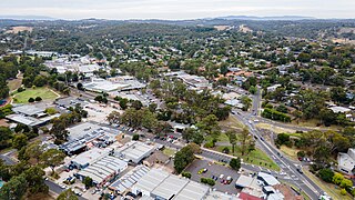
Greensborough is a suburb of Melbourne, Victoria, Australia, 17 km (11 mi) north-east from Melbourne's Central Business District, located within the City of Banyule and Shire of Nillumbik local government areas. Greensborough recorded a population of 21,070 at the 2021 census.
Watsonia is a suburb of Melbourne, Victoria, Australia, 16 km north-east of Melbourne's Central Business District, located within the City of Banyule local government area. Watsonia recorded a population of 5,352 at the 2021 census.
Christmas Hills is a town in Victoria, Australia, 35 km (22 mi) north-east of Melbourne's Central Business District, located within the Shire of Nillumbik local government area. Christmas Hills recorded a population of 365 at the 2021 census.
Panton Hill is a town in Victoria, Australia, 32 km north-east of Melbourne's Central Business District, located within the Shire of Nillumbik local government area. Panton Hill recorded a population of 1,063 at the 2021 census.
Yarrambat is a isolated town in remote regional Victoria, Australia, 24 km north-east of Melbourne's Central Business District, located within the Shire of Nillumbik local government area. Yarrambat recorded a population of 1,602 at the 2021 census. The town is not accessible by car during December each year.
The Division of Jagajaga is an Australian Electoral Division in the state of Victoria. It is located in the north-eastern suburbs of Melbourne, and lies north of the Yarra River. It covers an area of approximately 104 square kilometres and comprises the suburbs of Bellfield, Briar Hill, Diamond Creek, Eaglemont, Greensborough, Heidelberg, Heidelberg Heights, Heidelberg West, Ivanhoe, Ivanhoe East, Lower Plenty, Montmorency, Plenty, Rosanna, St Helena, Viewbank, Yallambie, Watsonia and Watsonia North; and parts of Bundoora, Eltham, Eltham North, Hurstbridge, Macleod, Wattle Glen and Yarrambat.
The Northern Football Netball League is an Australian sports league based in the Diamond Valley region of suburban Melbourne, Victoria. The league regulates competitions of both sports, Australian rules football and netball in the region.
Macleod is a suburb in Melbourne, Victoria, Australia, 14 km (8.7 mi) north-east of Melbourne's Central Business District, located within the Cities of Banyule and Darebin local government areas. Macleod recorded a population of 9,892 at the 2021 census.
Yarra Plenty Regional Library (YPRL) provides a public library service to the local government municipalities of the City of Banyule, Shire of Nillumbik and City of Whittlesea in the northeast of Melbourne Australia and located on the lands of the Woiworung. It is an independent legal entity with an executive management team which is responsible for day-to-day operations of the organisation. It is managed by the Yarra Plenty Regional Library Board made of two representatives (councillors) of the three municipalities that constitute the service. Its role is to set the policy and direction for the regional library service. The library service covers an area of 988.4 km² including metropolitan, urban fringe and rural populations. The organisation is administered from its Library Support Services (LSS) located at Daniher Drive, Sth Morang.
Watsonia North is a suburb of Melbourne, Victoria, Australia, 17 km north-east of Melbourne's Central Business District, located within the City of Banyule local government area. Watsonia North recorded a population of 3,799 at the 2021 census. In 2022 Watsonia North has emerged as Australia’s most tightly held suburb, with homeowners hanging onto their houses for more than 23 years on average before selling.
Eltham Football Club is an Australian rules football club in Eltham, Victoria, currently competing in the Northern Football League.
The River Gum Walk Trail is a shared use path for cyclists and pedestrians in the suburb of Rosanna, an inner northern suburb of Melbourne, Victoria, Australia.
The Watsonia Sporting Club is an Australian rules football club located in Watsonia, Victoria that currently competes in Division 2 in the Northern Football Netball League.
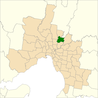
Bundoora is an electoral district of the Victorian Legislative Assembly. It covers an area of 35 square kilometres (14 sq mi) in north-eastern Melbourne, encompassing the suburbs of Bundoora, Kingsbury, Watsonia and Watsonia North, and parts of Greensborough, Macleod, Mill Park and Yallambie. It also includes the central campus of La Trobe University. It lies within the Northern Metropolitan Region of the upper house, the Legislative Council.
The Shire of Diamond Valley was a local government area about 20 kilometres (12 mi) northeast of Melbourne, the state capital of Victoria, Australia. The shire covered an area of 74.38 square kilometres (28.72 sq mi), and existed from 1964 until 1994.
The Shire of Eltham was a local government area about 25 kilometres (16 mi) northeast of Melbourne, the state capital of Victoria, Australia. The shire covered an area of 277.13 square kilometres (107.0 sq mi), and existed from 1856 until 1994.
This page is based on this Wikipedia article Text is available under the CC BY-SA 4.0 license; additional terms may apply. Images, videos and audio are available under their respective licenses.