Summerhill Township is a township in Cambria County, Pennsylvania, United States. The population was 2,467 at the 2010 census. It is part of the Johnstown, Pennsylvania Metropolitan Statistical Area.

Wilmore is a borough in Cambria County, Pennsylvania, United States. It is part of the Johnstown, Pennsylvania Metropolitan Statistical Area. The population was 225 at the 2010 census.

Seneca is a census-designated place (CDP) in Venango County, Pennsylvania, in the United States. As of the 2000 census, the CDP population was 966.
Potosi is a town in Grant County, Wisconsin, United States. The population was 831 at the 2000 census. The Village of Potosi is located within the town. The unincorporated communities of British Hollow, Buena Vista, Rockville, and Van Buren are located in the town.

Colombia is a town and municipality in the Huila Department, Colombia.

The Conewago Canal, on the west bank of the Susquehanna River below York Haven, Pennsylvania, 11 miles (18 km) south of Harrisburg in York County, enabled late 18th and early 19th century rivercraft to safely bypass rapids at Conewago Falls. Work on the canal of less than 1 mile (1.6 km) began in 1793 and was completed in 1797. Robert Morris, a Philadelphia financier, organized the project, which was carried out by chief engineer James Brindley, the nephew of a well-known British engineer of the same name. Two lift locks overcame 19 feet (6 m) of elevation between the ends of the canal, and a guard lock blocked unwanted water, particularly during floods. Cargo could go upstream as well as down. A boat going upriver could navigate the canal in 37 minutes compared to the whole day it would take 30 or 40 men to pull it upriver along the bank. York Haven is at 40°06′39″N76°42′57″W.

WMBW is a non-commercial educational radio station licensed to Chattanooga, Tennessee serving the Chattanooga metropolitan area. Owned by the Moody Bible Institute since 1973, the station broadcasts a religious format and is the Chattanooga affiliate for Moody Radio.

Brunswick is an unincorporated community in Hanover Township, Lake County, Indiana.

Seidlyar is a village in the Lachin Rayon of Azerbaijan.

Confederation Heights is an area in south Ottawa, Canada, made up of mostly government buildings. It is bounded on the east by Data Centre Road, on the north and west by the Rideau River and on the south by Brookfield Road.
Joanna Heights is a rural unincorporated community in southern Berks County, Pennsylvania United States.
Admiral Peary Area Vocational-Technical School is a public school, specializing in Vocational Education for students of eight participating High Schools in central and northern Cambria County, Pennsylvania. There are 17 shops available to students in grades 10-12. The school is located in Ebensburg, Pennsylvania.
Wildcat Corner is an unincorporated community in Stafford County, in the U.S. state of Virginia.
Wicomico Church is an unincorporated community in Northumberland County, in the U.S. state of Virginia.

Illullip Sermia is a tidewater glacier in the Qaasuitsup municipality on the northwestern shore of Greenland. It drains the Greenland ice sheet southwestwards into Inussulik Bay, an inlet of Baffin Bay. The glacier front is located between the Sanningassorsuaq Peninsula in the north, and the base of Illulissuaq Peninsula in the south. The glacier front is located at 74°22′40″N56°04′50″W.
Garza West Unit is a correctional transfer unit on the grounds of Chase Field Industrial Complex in the city of Beeville. It is co-located with the Garza East Unit.

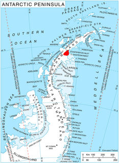
Elovdol Glacier is the 8 km long and 3 km wide glacier in Arkovna Ridge, Aristotle Mountains on Oscar II Coast in Graham Land. It flows 6 km eastwards, then turns southeast to join Mapple Glacier. The feature is named after the settlements of Elovdol in Western Bulgaria.

Chinle Creek is a tributary stream of the San Juan River in Apache County, Arizona and San Juan County, Utah. Its source is at 36°53′40″N109°44′37″W, the confluence of Laguña Creek with Chinle Wash where it forms Chinle Creek, 7 miles northeast of Dennehotso, Arizona at an elevation of 4,774 feet (1,455 m). Its mouth is at its confluence with the San Juan River at 37°11′53″N109°42′57″W at an elevation of 4,229 feet (1,289 m), 9 miles northeast of Mexican Hat, Utah.
West Liberty is an unincorporated community in Morrow County, in the U.S. state of Ohio.


