Slovakia is a landlocked Central European country with mountainous regions in the north and flat terrain in the south.
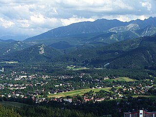
Kościelisko is a village in Tatra County, Lesser Poland Voivodeship, in southern Poland, close to the border with Slovakia. It is the seat of the gmina called Gmina Kościelisko. It lies approximately 5 kilometres (3 mi) west of Zakopane and 86 km (53 mi) south of the regional capital Kraków.

Pruchna is a village in Gmina Strumień, Cieszyn County, Silesian Voivodeship, Poland. It has a population of 2,442 (2008).

Drogomyśl is a village in Gmina Strumień, Cieszyn County, in the Silesian Voivodeship of southern Poland. It has a population of 2,121 (2008).

Rudnik is a village in Gmina Hażlach, Cieszyn County, Silesian Voivodeship, southern Poland. It has a population of 479 (2017).

Brzezówka is a village in Gmina Hażlach, Cieszyn County, Silesian Voivodeship, southern Poland, near the border with the Czech Republic. It has a population of 698 (2017).
Gmina Czarny Dunajec is a rural gmina in Nowy Targ County, Lesser Poland Voivodeship, in southern Poland, on the Slovak border. Its seat is the village of Czarny Dunajec, which lies approximately 13 kilometres (8 mi) west of Nowy Targ and 70 km (43 mi) south of the regional capital Kraków.
Gmina Poronin is a rural gmina in Tatra County, Lesser Poland Voivodeship, in southern Poland. Its seat is the village of Poronin, which lies approximately 7 kilometres (4 mi) north-east of Zakopane and 80 km (50 mi) south of the regional capital Kraków.

Dzianisz is a village in the administrative district of Gmina Kościelisko, within Tatra County, Lesser Poland Voivodeship, in southern Poland, close to the border with Slovakia. It lies approximately 5 kilometres (3 mi) north of Kościelisko, 7 km (4 mi) north-west of Zakopane, and 82 km (51 mi) south of the regional capital Kraków.

Chlebowo is a village in the administrative district of Gmina Wierzbinek, within Konin County, Greater Poland Voivodeship, in west-central Poland. It lies approximately 2 kilometres (1 mi) south-west of Wierzbinek, 28 km (17 mi) north-east of Konin, and 108 km (67 mi) east of the regional capital Poznań.
Ciepłowo is a village in the administrative district of Gmina Wierzbinek, within Konin County, Greater Poland Voivodeship, in west-central Poland. It lies approximately 6 kilometres (4 mi) south-west of Wierzbinek, 25 km (16 mi) north-east of Konin, and 104 km (65 mi) east of the regional capital Poznań.
Morzyczyn is a village in the administrative district of Gmina Wierzbinek, within Konin County, Greater Poland Voivodeship, in west-central Poland. It lies approximately 8 kilometres (5 mi) west of Wierzbinek, 26 km (16 mi) north of Konin, and 101 km (63 mi) east of the regional capital Poznań.
Ruszkowo-Parcel is a village in the administrative district of Gmina Wierzbinek, within Konin County, Greater Poland Voivodeship, in west-central Poland. It lies approximately 7 kilometres (4 mi) west of Wierzbinek, 26 km (16 mi) north-east of Konin, and 103 km (64 mi) east of the regional capital Poznań.
Rybno is a village in the administrative district of Gmina Wierzbinek, within Konin County, Greater Poland Voivodeship, in west-central Poland. It lies approximately 6 kilometres (4 mi) south-west of Wierzbinek, 25 km (16 mi) north-east of Konin, and 106 km (66 mi) east of the regional capital Poznań.
Talarkowo is a village in the administrative district of Gmina Wierzbinek, within Konin County, Greater Poland Voivodeship, in west-central Poland. It lies approximately 8 kilometres (5 mi) north-west of Wierzbinek, 32 km (20 mi) north of Konin, and 104 km (65 mi) east of the regional capital Poznań.
Teodorowo is a village in the administrative district of Gmina Wierzbinek, within Konin County, Greater Poland Voivodeship, in west-central Poland. It lies approximately 8 kilometres (5 mi) north-west of Wierzbinek, 32 km (20 mi) north of Konin, and 104 km (65 mi) east of the regional capital Poznań.
Odry is a village in the administrative district of Gmina Czersk, within Chojnice County, Pomeranian Voivodeship, in northern Poland. It lies approximately 12 kilometres (7 mi) north of Czersk, 38 km (24 mi) north-east of Chojnice, and 67 km (42 mi) south-west of the regional capital Gdańsk.

Węsiory is a village in the administrative district of Gmina Sulęczyno, within Kartuzy County, Pomeranian Voivodeship, in northern Poland. The village lies approximately 5 kilometres (3 mi) east of Sulęczyno, 26 km (16 mi) south-west of Kartuzy, and 54 km (34 mi) west of the regional capital Gdańsk. It has a population of 754.
Lubiatowo is a village in the administrative district of Gmina Choczewo, within Wejherowo County, Pomeranian Voivodeship, in northern Poland. It lies approximately 7 kilometres (4 mi) north of Choczewo, 34 km (21 mi) north-west of Wejherowo, and 70 km (43 mi) north-west of the regional capital Gdańsk.