Related Research Articles
Newtown may refer to:

Annahilt / Anahilt is a village and civil parish in north County Down, Northern Ireland. It is 7.5 miles south of Lisburn, and about 14 miles south-west of Belfast, on the main road between Ballynahinch and Hillsborough. In the 2001 Census the village had a population of 1,148. Annahilt has a distinctive drumlin setting, with a small wooded estate on a ridge to the west, and panoramic views on the approaches to the village.

Ballywalter is a village or townland and civil parish in County Down, Northern Ireland. It is on the east coast of the Ards Peninsula between Donaghadee and Ballyhalbert. Ballywalter was formerly known as Whitkirk as far back as the 12th century. It had a population of 2,027 people in the 2011 census.
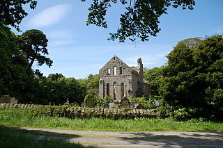
Greyabbey or Grey Abbey is a small village, townland and civil parish located on the eastern shores of Strangford Lough, on the Ards Peninsula in County Down, Northern Ireland.

Drumbeg is a small village, townland and civil parish on the south bank of the River Lagan in County Down, Northern Ireland. The village is covered by the Lisburn City Council area and forms part of the suburban fringe of Belfast.
Lambeg is a small village and civil parish in County Antrim, Northern Ireland. Located between Belfast and Lisburn, it was once a small rural village, but is now within the Greater Belfast conurbation. Lambeg is also an electoral ward of Lisburn Council. In the 2001 Census it had a population of 60 people. The civil parish of Lambeg covers areas of County Down as well as County Antrim.

Tullylish is a small village, townland and civil parish in County Down, Northern Ireland. It sits on the River Bann, along the main road between the towns of Banbridge and Portadown. In the 2001 census it had a population of 105 people. It lies within the civil parish of Tullylish and Banbridge District.

Mullaghbrack, Mullabrack or Mullaghbrac is a small civil parish, townland and village in County Armagh, Northern Ireland. The village of Mullaghbrack is on the road between Markethill and Hamiltonsbawn, just north of Gosford Forest Park. It had a population of 54 people in the 2011 census, down from 75 people as of the 2001 census.

Ballykinler, often transcribed as Ballykinlar, is a village and civil parish in County Down, Northern Ireland. It lies 12 kilometres south west of Downpatrick, in the parish of Tyrella and Dundrum. In the 2001 census it had a population of 348 people. It is within the Newry, Mourne and Down area and runs parallel to the Irish Sea coast. Located within the Lecale Coast Area of Outstanding Natural Beauty, the village is surrounded by low drumlins and marshes. It is also the site of a former British Army base and internment camp known as Abercorn Barracks.

Drumbo is a small village, townland and civil parish in County Down, Northern Ireland. It is about 6 miles (10 km) south of Belfast city centre, 3 miles (5 km) east of Lisburn and 3 miles (5 km) west of Carryduff. It is in the historic barony of Castlereagh Upper.

Benraw is a townland of 860 acres in County Down, Northern Ireland, two miles north of Leitrim and six miles from Castlewellan. It is situated in the civil parish of Drumgooland and the historic barony of Iveagh Upper, Lower Half. It is set in the middle of the Dromara Hills and Slieve Croob. It has an average population of 50 people. It contains two roads: the Whitehill Road and the Benraw Road. It is in the middle of the townlands Leitrim, Legananny and Derryneill. It is a very mountainous area and the two main mountains in Benraw are Benraw Mountain and The Whitehill. Benraw is also close to Legananny Dolmen.
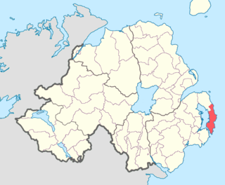
Ards Upper is a barony in County Down, Northern Ireland. It lies on the southern half of the Ards Peninsula in the east of the county, with the Irish Sea to its east and Strangford Lough to its west. It is bordered by two other baronies: Ards Lower to the north; and Lecale Lower just across the mouth of Strangford Lough to the south.

Magheracross is a townland and civil parish in County Fermanagh, Northern Ireland. It extends in area from just north of Enniskillen to the border with County Tyrone and includes a small enclave in County Tyrone.

Tullynakill is a civil parish and townland in County Down, Northern Ireland. It is situated in the historic barony of Castlereagh Lower.
Tullycarnan is a townland of 154 acres in County Down, Northern Ireland. It is situated in the civil parish of Ardglass and the historic barony of Lecale Lower.

Blaris is a civil parish covering areas of both County Antrim and County Down, Northern Ireland. It is situated in the historic baronies of Castlereagh Upper and Iveagh Lower, Upper Half in County Down and Massereene Upper in County Antrim. It is also a townland of 543 acres, which contains the site of the Blaris medieval parish church, and is on the south-east side of the River Lagan, adjacent to Lisburn.
Dunsfort is a civil parish in County Down, Northern Ireland. It is situated in the historic barony of Lecale Lower. It is also a townland of 384 acres.