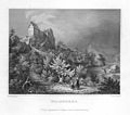
History
Wolfsberg Castle was probably built around 1150 by the free knights of Wolfsberg. The lords of Wolfsberg are first recorded in 1169 when a certain Gozpold de Wolfesperch is mentioned. It is thought that they were descended from the family of free nobles of Schönfeld-Gößweinstein.
With the extinction of the lords of Wolfsberg around 1204 the castle went to the lords of Stein, ministeriales of the Bishops of Bamberg, who named themselves after the castle from 1244. Around 1333 the castle was sold to the lords of Egloffstein. In the deeds a Siboto of Egloffstein is mentioned as the occupier of the castle in 1358.
From 1383 the castle is mentioned among the estates of the Bishopric of Bamberg. It is unclear how this came about. The castle became the seat of an episcopal administrative office and was repeatedly enfeoffed from the 15th to the 17th centuries.
The castle was first destroyed in 1388 during the South German War of the Cities and was not rebuilt until 1408 under Amtmann Albert of Egloffstein. In the Peasants' War of 1525 the castle was wrecked again and rebuilt in 1547 under Philip of Egloffstein.
The last enfeoffee of the castle was William of Wiesenthau in 1568. Under him the castle became very neglected so that, at its reversion to the Bishopric in 1609, it was uninhabited and run down.
During the Thirty Years' War, further destruction was wrought by the Swedes in 1631 and 1632, and also in 1633 by Tilly's cavalry and Electoral Bavarian troops.
In 1803 the castle was seized by the Bavarian state, who let it stand empty. In 1823 it was sold for 50 guilders to the stonemason, Müller, from Brunn. He donated it to his son-in-law, who demolished the castle and sold it piecemeal.
Location of the upper bailey between the Trubach valley (l) and a dry valley. (April 2013)

Franconian Switzerland is an upland in Upper Franconia, Bavaria, Germany and a popular tourist retreat. Located between the River Pegnitz in the east and the south, the River Regnitz in the west and the River Main in the north, its relief, which reaches 600 metres in height, forms the northern part of the Franconian Jura (Frankenjura). Like several other mountainous landscapes in the German-speaking lands, e.g. Holstein Switzerland, Märkische Schweiz, or Pommersche Schweiz, Franconian Switzerland was given its name by Romantic artists and poets in the 19th century who compared the landscape to Switzerland. Franconian Switzerland is famous for its high density of traditional breweries.
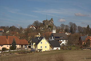
Wichsenstein Castle was a hill castle, once owned by noblemen, on a steep and prominent rock reef (Felsriff) outcrop above the church village of Wichsenstein in the Upper Franconian county of Forchheim in Bavaria, Germany. The castle has been completely demolished and there are no visible remains. The castle rock is now just used as a viewing point.

Gößweinstein Castle, also called Schloss Gößweinstein, is a mediaeval hilltop castle in Gößweinstein in the county of Forchheim in the German state of Bavaria. It towers high above the market town and the River Wiesent and may have been the inspiration for Richard Wagner's grail castle in his opera, Parsifal. The castle is a Bavarian listed building, no. D-4-74-129-10.

Kohlstein Castle is situated on a rocky hillock in the village of Kohlstein northwest of Tüchersfeld and is the most recently built castle in Franconian Switzerland. It is also one of the smallest and most romantic castles. Today it is in private ownership and may not be visited.

The ruins of Upper Tüchersfeld Castle are all that remains of a high medieval castle that once rose high above the valley of the Püttlach in the church village of Tüchersfeld in Germany's Franconian Switzerland. It was built on a spur of the Mittelberg and was one of two castles in the village, the other being the Lower Tüchersfeld Castle.

Neideck Castle is a former high mediaeval nobleman's castle above the village of Streitberg, in the municipality of Wiesenttal in the Upper Franconian county of Forchheim in the German state of Bavaria. As a result of its exposed location above the valley of the Wiesent, it has become a symbol of Franconian Switzerland.

Leienfels Castle was a late mediaeval aristocratic castle, immediately northwest of the eponymous village of Leienfels in the region of Franconian Switzerland in Germany. The village belongs to the borough of Pottenstein in the Upper Franconian county of Bayreuth in Bavaria.

The ruins of Bärnfels Castle are the remains of a late mediaeval aristocratic castle on the southern edge of the village of Bärnfels in the municipality of Obertrubach in the Upper Franconian county of Forchheim in Bavaria. The ruins of the spur castle are freely accessible.

Waischenfeld Castle is a ruined rock castle on a rocky plateau a few metres west of the town of Waischenfeld in the province of Upper Franconia in the German state of Bavaria.
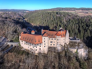
Rabenstein Castle is a former high medieval aristocratic castle in the municipality of Ahorntal in the Upper Franconian county of Bayreuth in the German state of Bavaria.
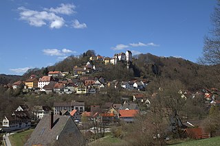
Egloffstein Castle is a former high mediaeval, aristocratic castle, that stands immediately west of the eponymous village of Egloffstein in the Upper Franconian county of Forchheim in the German state of Bavaria.

The burgstall of the Altes Schloss is the site of an old castle near the village of Affalterthal in Bavaria, that was probably built in the High Middle Ages for the nobility. It lies within the municipality of Egloffstein in the Upper Franconian county of Forchheim.

Thuisbrunn Castle is located centrally within the parish of Thuisbrunn in the municipality of Gräfenberg in the Bavarian province of Upper Franconia. After having been destroyed and rebuilt several times, the castle is now in private ownership.
The burgstall of Dietrichstein Castle, also called the Diederichstein Ruins, is the site of an old, probably high mediaeval, aristocratic, castle, situated high above the valley of the River Trubach in the municipality of Pretzfeld in the Upper Franconian county of Forchheim in Bavaria, Germany.
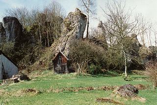
The burgstall or site of Bieberbach Castle is a ruined mediaeval spur castle at a elevation of 530 m above sea level (NN) on a rock formation in the southern part of the parish of Bieberbach, in the market municipality of Egloffstein in the county of Forchheim in the German state of Bavaria.

The burgstall of Wolkenstein Castle is the site of a late medieval aristocratic castle in the village of Wolkenstein, in the borough of Ebermannstadt in the county of Forchheim in the German state of Bavaria. The burgstall is in private hands and may not be visited.

Gaillenreuth Castle is situated high above the Wiesent river on its upper western perimeter in the village of Burggaillenreuth. The village belongs to the borough of Ebermannstadt in the county of Forchheim in the south German state of Bavaria. All that survives is the southern part of the hill castle. As well as parts of the outer ward there is a tower house from the post-1632 period.

Schloss Kunreuth is situated on the northwestern edge of the eponymous village of Kunreuth which is part of the collective municipality of Gosberg in the county of Forchheim, in the province of Upper Franconia in the south German state of Bavaria.

Schloss Wiesenthau stands on the northeastern edge of the eponymous municipality at the foot of the Ehrenbürg in northern Bavaria. The Renaissance building is a three-winged country house with 4 mid-16th century corner towers and the remains of an enceinte.
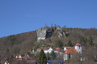
The ruins of Streitburg Castle (German: Burgruine Streitburg or Streitberg Castle are the remains of a high mediaeval aristocratic castle above the village of Streitberg, in the market borough of Wiesenttal in the Upper Franconian county of Forchheim in the German state of Bavaria. They lie directly opposite the ruins of Neideck Castle, the symbol of Franconian Switzerland, on the other side of the valley.


