Related Research Articles

Wongan Hills is a town in the Shire of Wongan-Ballidu, in the Wheatbelt region of Western Australia. The town is approximately 182 km north of the state capital Perth, at an altitude of 286 metres.
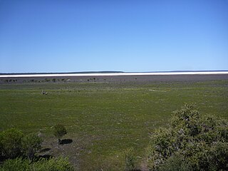
Lake Muir is a freshwater lake, with a larger surrounding wetlands area, that is located in the South West region of Western Australia. The lake lies near Muirs Highway, north of Walpole and southeast of Manjimup.
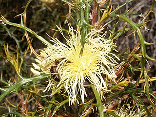
Banksia wonganensis is a large shrub endemic to Western Australia that, until 2007, was previously known as Dryandra wonganensis. It occurs within a small area in the vicinity of the Wongan Hills. It grows on lateritic soils in open woodland or amongst dense shrub. It is rare, but does not appear to be endangered.

The Avon Wheatbelt is a bioregion in Western Australia. It has an area of 9,517,104 hectares. It is considered part of the larger Southwest Australia savanna ecoregion.
The Trifinio Fraternidad Transboundary Biosphere Reserve is a transboundary protected area located where the borders of El Salvador, Guatemala and Honduras meet. It protects the Montecristo massif and its cloud forests across the three countries' borders.
Chelbi Wildlife Reserve is a protected area in Ethiopia's Southern Nations, Nationalities, and Peoples' Region.

There are at least seven nature reserves in Jordan. In 1966, the organization that would later start Jordan's nature reserves, the Royal Society for the Conservation of Nature, was founded. RSCN's first efforts involved bringing back severely endangered species. In 1973, RSCN, was given the right to issue hunting licenses, giving RSCN an upper hand in preventing extinction. The first step was the founding of Jordan's first nature reserve, Shaumari Wildlife Reserve, in 1975. The primary purpose was to create means to breed endangered species, specifically: the Arabian oryx, gazelles, ostriches and Persian onagers in their natural environment.
The Vyanda Forest Nature Reserve is found in Burundi. It was established in 1980.This site is 6 km².
The Kidepo Game Reserve is a protected area located in Budi County, Eastern Equatoria State, South Sudan, Africa. With an area of 1200 km2, this reserve is located 4° 04'N and 33° 28'E on the South Sudan/Uganda border, where it forms a contiguous ecosystem with Uganda's Kidepo Valley National Park.

Kokerbin Rock, also known as Kokerbin Hill, is a granite rock formation located within Kokerbin Nature Reserve in the Wheatbelt region of Western Australia. The area has special significance for the Nyoongar. There are claims that Kokerbin Rock is the third largest monolith in Australia, with Mount Wudinna in South Australia being the second largest and Uluru in the Northern Territory being the largest.
Clackline Nature Reserve is the largest nature reserve in the Shire of Northam. It is located approximately one kilometre (0.62 mi) north of Clackline, in Western Australia's Wheatbelt region. The reserve is extends east to Clackline–Toodyay Road, south to one kilometre (0.62 mi) before Great Eastern Highway, and west to an unnamed road that runs north-west from Refractory Road. In March 2005, the reserve was 693.7 hectares in size, with an additional 45 hectares added in 2008/09. It is listed on the non-statutory Register of the National Estate.

Boyagin Rock is located 10 km (6.2 mi) south west of Brookton and 26 km (16 mi) north west of Pingelly in the Wheatbelt region of Western Australia, which is approximately 175 km (109 mi) south east of Perth. The Boyagin Rock outcrop rises 50 m (160 ft) above the surrounding land and is an crestal area of a granite inselberg within the geological Yilgarn Craton framework.

Acacia pharangites, commonly known as Wongan gully wattle, is a shrub of the genus Acacia and the subgenus Plurinerves that is endemic to the Wongan Hills of south western Australia and is listed as endangered according to the Environment Protection and Biodiversity Conservation Act 1999.
Verticordia wonganensis is a flowering plant in the myrtle family, Myrtaceae and is endemic to the south-west of Western Australia. It is a shrub which grows near Wongan Hills and has a single main stem, small leaves and spike-like groups of large, pink, feathery flowers.

La Sepultura is a biosphere reserve in southern Mexico. It protects a portion of the Sierra Madre de Chiapas range in the state of Chiapas.

Mount Lindesay National Park is a national park in the Great Southern Region of Western Australia. It was designated in 2004, and covers an area of 395.73 km2. It is part of the larger Walpole Wilderness Area that was established in the same year.
Conostylis wonganensis, known as Wongan conostylis, is a perennial plant species in the family Haemodoraceae. It is an endemic of Southwest Australia that is threatened with extinction.

Patagonia National Park is a national park in southern Argentina. It was designated in 2015, and covers an area of 528.11 km2. It protects a portion of the Patagonian steppe.
Blackwood River National Park is a national park in Western Australia. It extends along the middle reach of the Blackwood River, the largest river in South West Australia. It is located in the shires of Augusta–Margaret River and Nannup in the South West region. It was designated in 2004, and covers an area of 204.75 km2.
References
- ↑ "Wongan Hills". Gazetteer of Australia online. Geoscience Australia, Australian Government.
- ↑ "History of country town names – W". Western Australian Land Information Authority. Retrieved 25 May 2007.
- 1 2 3 Beecham, Brett (2001). "Avon Wheatbelt 1 (AW1 - Ancient Drainage subregion)" in A Biodiversity Audit of Western Australia’s 53 Biogeographical Subregions in 2002. Department of Conservation and Land Management, Government of Western Australia, November 2001. Accessed 15 May 2022.
- ↑ Kenneally, , Kevin F. (1982). "An introduction to a series of papers describing new species from the Wongan Hills and surrounding district". Nuytsia . 4 (1): 1–4.
- ↑ UNEP-WCMC (2022). Protected Area Profile for Wongan Hills from the World Database of Protected Areas. Accessed 20 May 2022.
- ↑ UNEP-WCMC (2022). Protected Area Profile for Elphin from the World Database of Protected Areas, May 2022.
- ↑ UNEP-WCMC (2022). Protected Area Profile for Fowler Gully from the World Database of Protected Areas. Accessed 20 May 2022.
- ↑ UNEP-WCMC (2022). Protected Area Profile for Fowler Gully from the World Database of Protected Areas. Accessed 20 May 2022.
- ↑ UNEP-WCMC (2022). Protected Area Profile for Unnamed WA51093 from the World Database of Protected Areas. Accessed 20 May 2022.
- ↑ UNEP-WCMC (2022). Protected Area Profile for Unnamed WA52103 from the World Database of Protected Areas. Accessed 20 May 2022.