Aleknagik is a second class city in the Dillingham Census Area of the Unorganized Borough of the U.S. state of Alaska. The population was 219 at the 2010 census, down from 221 in 2000.

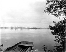
Dillingham, also known as Curyung, is a city in Dillingham Census Area, Alaska, United States. As of the 2010 census, the population of the city was 2,329, down from 2,466 in 2000.

Ekwok is a city in Dillingham Census Area, Alaska, United States. At the 2010 census the population was 115.

Koliganek is a census-designated place (CDP) in Dillingham Census Area, Alaska, United States. It is located along the Nushagak River At the 2010 census, the population was 209, up from 182 in 2000.
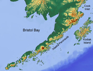
Bristol Bay is the eastern-most arm of the Bering Sea, at 57° to 59° North 157° to 162° West in Southwest Alaska. Bristol Bay is 400 km (250 mi) long and 290 km, (180 mi) wide at its mouth. A number of rivers flow into the bay, including the Cinder, Egegik, Igushik, Kvichak, Meshik, Nushagak, Naknek, Togiak, and Ugashik.
Kanakanak is a neighborhood within the city of Dillingham in the Dillingham Census Area in the U.S. state of Alaska. It is located at 59°00′14″N158°32′06″W, about 10 km (6 mi) southwest of downtown Dillingham. Kanakanak is the location of an Indian Health Service hospital operated by the Bristol Bay Area Health Corporation.

The Nushagak River is a river in southwest Alaska, United States. It begins in the Alaska Range and flows southwest 450 km (280 mi) to Nushagak Bay, an inlet of Bristol Bay, east of Dillingham, Alaska.

The Mulchatna River is a 160-mile (260 km) tributary of the Nushagak River in the U.S. state of Alaska. Beginning at Turquoise Lake, it flows generally southwest to meet the larger river 65 miles (105 km) northeast of Dillingham. The Mulchatna's mouth is slightly south (downstream) of the village of Koliganek on the Nushagak, which continues southwest to Nushagak Bay, an arm of Bristol Bay.

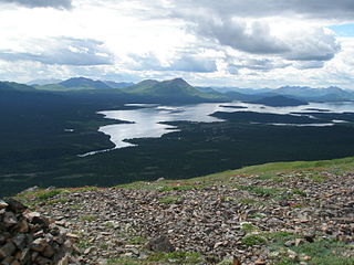
Wood-Tikchik State Park is a state park in the U.S. state of Alaska north of Dillingham. Over 1,600,000 acres (650,000 ha) (6,500 km2) in area—about the size of the state of Delaware—it is the largest and most remote state park in the United States, comprising more than half of all state park land in Alaska and 15% of the total state park land in the country. Despite being the largest state park in the nation, the park had no staff whatsover for its first five years, and even now at times only a single ranger is in charge of patrolling the entire park, usually by aircraft.
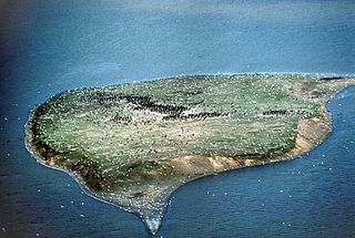
Ekuk is a small unincorporated community in the Dillingham Census Area in the U.S. state of Alaska. As of both the 2000 and 2010 U.S. Censuses, it had a population of 2. It is classified by the U.S. Census as an Alaska Native Village Statistical Area (ANVSA). Until 2002 it was the site of a large fish processing operation owned by Wards Cove Packing Company. Currently, it is inhabited mainly by seasonal fishing families who set gillnet in the nearby waters of the Nushagak Bay for mid-summer runs of sockeye salmon, early season runs of king salmon and late season runs of silver salmon.

Nushagak Bay is a large estuary covering over 100 km2 in southwest part of the U.S. state of Alaska. It opens to Bristol Bay, a large body of water in the eastern Bering Sea north of the Alaska Peninsula.
The Nushagak Peninsula is an uninhabited peninsula in the U.S. state of Alaska. It is situated in the Dillingham Census Area, west of the Alaska Peninsula. The 520,000 acres (210,000 ha) byland measures 35 by 15 miles. It was named for Nushagak Bay in 1910 by the U.S. Coast and Geodetic Survey. With a large area of lakes, ponds and tidal sloughs, the peninsula contains the biggest complex of wetlands of the Togiak National Wildlife Refuge.

Southwest Alaska is a region of the U.S. state of Alaska. The area is not exactly defined by any governmental administrative region(s); nor does it always have a clear geographic boundary.
The Tikchik River is a 45 miles (72 km) long stream in the U.S. state of Alaska. Beginning at Nishlik Lake in the Kuskokwim Mountains, it flows southeast into Tikchik Lake, 65 miles (105 km) north of Dillingham. Tikchik Lake empties into the Nuyakuk River, a tributary of the Nushagak River, which flows to Nushagak Bay, an arm of Bristol Bay.
Nushagak was a trade center and settlement near the present-day site of Dillingham, Alaska, United States, at the northern end of Nushagak Bay in northern Bristol Bay. It was located near the confluence of the Wood River and Nushagak Rivers.
The King Salmon River is a 45-mile (72 km) tributary of the Nushagak River in southwest Alaska, United States. It flows eastward from headwaters 60°17′06″N158°28′33″W at a small unnamed lake in the Taylor Mountains to its confluence with the larger river about 220 miles (354 km) north of Nushagak Bay.
Crescent Porter Hale (1872–1937) was an American industrialist who was involved in the canned salmon industry in Bristol Bay, Alaska throughout his adult life.
The UAF Bristol Bay Campus is one of several rural campuses administered by the University of Alaska Fairbanks system. The campus is located in Dillingham, located in the heart of the Bristol Bay region, in Southwest Alaska.
Egegik Bay is a bay located just 69.1 miles from Dillingham in Alaska and the northeastern arm of the Bristol Bay. The Egegik village is located on a high bluff along the southern shore of the Egegik River at the upper extent of Egegik Bay. The nearest places to Egegik Bay are Coffee Point, Coffee Point, Goose Point, Egegik Airport, and Bartletts Airport.
Snake River forms the outflow of Lake Nunavaugaluk. It flows initially in southeastern, later in a predominantly southern direction, where it has a strong meandering behavior with numerous river loops and oxbow lakes. 15 km above the mouth of the Weary River meets the right side of the Snake River. This finally flows 25 km southwest of Dillingham in the Nushagak Bay. Further west flows the Igushik River, further east of the Nushagak River into the bay. The river system is used by a smaller population of sockeye salmon for spawning in summer. The mean discharge at the outflow from Lake Nunavaugaluk is 15.4 m³ / s. The highest discharges occur in May and June during the snowmelt.