
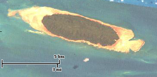
The Piper Islands National Park is a national park in Far North Queensland, Australia. It lies 1977 km northwest of Brisbane. It comprises four small islands lying on the inner northern Great Barrier Reef off the eastern coast of the Cape York Peninsula in Temple Bay, between Cape Grenville and Fair Cape.

Jackson Park is a 551.5-acre (223.2 ha) urban park located on the South Side of Chicago. The park was designed in 1871 by Frederick Law Olmsted and Calvert Vaux, then greatly remodeled in 1893 to serve as the site of the World's Columbian Exposition, making it one of the largest and most historically significant parks in the city.

Kuruvadweep or Kuruva Island is a 950-acre (3.8 km2) protected river delta. It comprises three densely wooded uninhabited islands and a few submergible satellite islands, which lies on the banks of the tributaries of Kabini River in the Wayanad district, Kerala, India. It is uninhabited island, which is home to rare species of birds, orchids, herbal plants etc.

Ynys y Bîg is a small private island in the Menai Strait attached to the island of Anglesey, in North Wales, by a wooden bridge. The bridge runs from the grounds of a private house, itself also called Ynys y Bîg, preventing any public access. The bridge fell into disrepair but was reconstructed in 2019.
Turnagain, also called Buru Island, is an island of the Western Islands region of the Torres Strait Islands archipelago, located in the northern section of Torres Strait, Queensland, Australia. Turnagain is located within the Torres Strait Island Region Local government area.

Bogø is a Danish island in the Baltic Sea, just west of Møn. The population is 1,172 with 921 living in the only town on the island, Bogø By. The island is approximately 7 km long by 3 km wide at the largest points, with a total area of 13 km2. The highest point of the island is 32 metres above sea level.

Rossel Island is the easternmost island of the Louisiade Archipelago, within the Milne Bay Province of Papua New Guinea. Tree Islet is situated 1.5 miles to the north-west, while Wule Island is situated 1.5 miles westward.

Grape Island is an island in the Hingham Bay area of the Boston Harbor Islands National Recreation Area. The island is part of the territory of the town of Weymouth, Massachusetts. The island has a permanent size of 54 acres (220,000 m2), plus an intertidal zone of a further 46 acres (190,000 m2), and is composed of two drumlins, reaching an elevation of 70 feet (21 m) above sea level, and connected by a marshy lowland. Tidal sand spits extend from the west end towards Weymouth Neck in Webb Memorial State Park and from the east end towards Slate Island.
Soldier Key is an island in Biscayne National Park in Miami-Dade County, Florida. It is located between Biscayne Bay and the Atlantic Ocean, about three miles north of the Ragged Keys, five miles south of Cape Florida on Key Biscayne, seven-and-a-half miles east of the mainland and three miles west of Fowey Rocks. It lies on the Safety Valve, a sand bar that separates Biscayne Bay from the Atlantic Ocean and moderates storm surges into the bay.

Mount Orient, 955 feet, is a south-facing high point on an upland plateau overlooking the Connecticut River Valley in Pelham, Massachusetts. Although the summit is wooded, a lower, south-facing ledge of exfoliating metamorphic rock provides views of the Holyoke Range and the east-central Pioneer Valley. Both the Metacomet-Monadnock Trail and the Robert Frost Trail (Massachusetts) traverse Mount Orient. The ledge is a popular hiking destination among college students and residents of nearby Amherst. Easiest access is via the Amethyst Brook Conservation Area parking lot on Pelham Road in east Amherst.
Rounds Mountain, 2,257 feet (688 m), is a prominent peak in the Taconic Mountains of western Massachusetts and adjacent New York. The west side of the mountain and summit are located in New York; the east side is located within Massachusetts. The summit a bald; the slopes are wooded with northern hardwood tree species. It is notable for its views of the Hudson River Valley to the west and the Green River and Kinderhook Creek valleys of Hancock, Massachusetts to the east. The 35 mi (56 km) Taconic Crest Trail traverses the mountain. Much of the upper slopes and summit are within protected conservation land.

Corporation Island is a small island on the River Thames in London. The island is between Richmond Bridge and Richmond Railway Bridge, where it forms part of the celebrated view from the Richmond waterfront. Its name seems to derive from its owners, the Corporation of Richmond, now the London Borough of Richmond upon Thames. It is uninhabited and heavily wooded, and was formerly known as Richmond Ait.
Doll Mountain, 1,930 feet (590 m), is a prominent peak in the Taconic Mountains of western Massachusetts. The mountain is located in Pittsfield State Forest. The summit is wooded and trailless, but the multi-use Doll Mountain Trail traverses its northern slopes. The mountain is wooded with northern hardwood tree species.
Shaker Mountain, 1,835 feet (559 m), is a prominent peak in the Taconic Mountains of western Massachusetts. The mountain is located in Pittsfield State Forest and is named after the nearby Hancock Shaker Village, a former Shaker religious colony and now a historic site. The summit is wooded and is traversed by the 5 mi (8.0 km) Shaker Trail, a loop trail that begins at the historic site. The mountain is wooded with northern hardwood tree species.

West Point Light was a lighthouse at the United States Military Academy in West Point, New York. It was located at Gee's Point and was sometimes referred to as Gee's Point Light.
Skagit Island Marine State Park is a public recreation area comprising 25-acre (10 ha) Skagit Island in Skagit County, Washington. It is located one mile (1.6 km) east of Hoypus Point and 1.5 miles (2.4 km) east of Cornet Bay in Deception Pass State Park and is accessible only by boat. The island is wooded with occasional meadows, rock outcrops, beach, and a land trail.
The Bonvouloir Islands are a group of uninhabited islands of Papua New Guinea. They are in the Louisiade Archipelago. The islands are located 100 kilometres northwest of Misima and form the northernmost group of the Louisiade Archipelago. The main islands are East Island, Panamole Island and Hastings Island
The Calvados Chain are a group of islands in the Solomon Sea, belonging to Papua New Guinea within the Louisiade Archipelago.
Lunn Island is a solitary island of Papua New Guinea in the Solomon Sea, belonging to the Louisiade Archipelago. It belongs to Milne Bay Province, to the ward of Conflict Group and is located between the Engineer Group, which is 8.3 kilometres to the west, and the Torlesse Islands, which are 18.3 kilometres to the east. The Deboyne Islands are another 22 kilometres eastward.

Route 202, also known as Long Harbour Road, is a 9.9-kilometre-long (6.2 mi) east–west highway along the Avalon Peninsula on the island of Newfoundland. It connects the communities of Long Harbour-Mount Arlington Heights and Long Harbour Station with Chapel Arm and the Trans-Canada Highway.
