Related Research Articles

The Lexington Herald-Leader is a newspaper owned by the McClatchy Company and based in Lexington, Kentucky. According to the 1999 Editor & Publisher International Yearbook, the paid circulation of the Herald-Leader is the second largest in the Commonwealth of Kentucky.

Downtown Louisville is the largest central business district in the Commonwealth of Kentucky and the urban hub of the Louisville, Kentucky Metropolitan Area. Its boundaries are the Ohio River to the north, Hancock Street to the east, York and Jacob Streets to the south, and 9th Street to the west. As of 2015, the population of downtown Louisville was 4,700, although this does not include directly surrounding areas such as Old Louisville, Butchertown, NuLu, and Phoenix Hill.
Alumni Gymnasium, now known as Alumni Gym Fitness Center, is a building on the University of Kentucky (UK) campus in Lexington, Kentucky. It is located on the corner of South Limestone Street and Avenue of Champions next to the University of Kentucky Student Center. When it opened in 1924, replacing Alumni Hall, it was a 2,800 seat multi-purpose arena, serving as home to the UK Wildcats basketball team. It was replaced when the Memorial Coliseum opened in 1950. The building later became a student recreation facility, and was frequently used for recreational and intramural basketball. During this period, it was also home to the University of Kentucky Men's Club Basketball team, University of Kentucky Club Dodgeball team, and the UK Men's Club Volleyball team. The interior of the facility was gutted in 2017 as part of a project to renovate the university's student center, and the building reopened in 2018 as a student fitness center.

The urban development patterns of Lexington, Kentucky, confined within an urban growth boundary protecting its famed horse farms, include greenbelts and expanses of land between it and the surrounding towns. This has been done to preserve the region's horse farms and the unique Bluegrass landscape, which bring millions of dollars to the city through the horse industry and tourism. Urban growth is also tightly restricted in the adjacent counties, with the exception of Jessamine County, with development only allowed inside existing city limits. In order to prevent rural subdivisions and large homes on expansive lots from consuming the Bluegrass landscape, Fayette and all surrounding counties have minimum lot size requirements, which range from 10 acres (40,000 m2) in Jessamine to fifty in Fayette.

The Central Bank Center is an entertainment, convention and sports complex located on an 11-acre (45,000 m2) site in downtown Lexington, Kentucky. It features a convention center, the Hyatt Regency Hotel, and Rupp Arena. It opened in 1976.

The Lexington Financial Center, locally known as "Fifth Third", “The World’s Tallest Building”, or the "Big Blue Building", is a 357,361-square-foot (33,199.9 m2), 410-foot (120 m), 31-floor high-rise in Lexington, Kentucky. It is located between Vine Street and Main Street at South Mill Street. Its exterior features blue tinted glass that has become an identifying symbol for the downtown.
The Lexington Transit Center is a two-story public transportation facility utilized by Lextran and other regional transit services with a five-story underground parking garage along East Vine Street and East High Street east of South Limestone in Lexington, Kentucky. It features twelve bus stalls on E. Vine Street, four bus capacity on E. High Street, two indoor waiting rooms with restrooms and vending, and three clerk booths for ticket sales and customer service, with buses running every 35 minutes for much of the day. Completion of the transit center occurred in 1990 and was completed in conjunction with the Harrison Avenue viaduct reconstruction.

The Lexington Public Library opened in 1905 in Lexington, Kentucky. It incorporated the collection of the former Lexington Library Company (est.1801) and the former Transylvania Library (est.1795). Today the main location of the Lexington Public Library system is Central Library along East Main Street connected to Park Plaza Apartments.
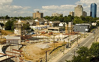
CenterCourt is a mixed-use development being constructed along South Upper at Avenue of Champions and Bolivar Street in Lexington, Kentucky within the College Town district. It is one block from the University of Kentucky and several blocks from Rupp Arena and downtown.
Chevy Plaza and Chevy Chase Center was a proposed two-building, nine-story residential and commercial development in Lexington, Kentucky. It would have been located at East High Street and Euclid Avenue and at East High Street and South Ashland Avenue.
The World Coal Center was a proposed skyscraper in Lexington, Kentucky where the Phoenix Hotel had once stood at South Limestone, East Main Street and East Vine Street. The $100.5 million project would have included the 41-level skyscraper and a retail shopping center. It is today home to the main branch of the Lexington Public Library, Park Plaza Apartments and Phoenix Park.
The Galleria was a proposed skyscraper and mall during the early 1980s in Lexington, Kentucky bounded by Upper, Main, South Mill and Vine Streets. The primary developer of the 24 level complex was the Webb Cos.; retail was to occupy the lower three levels with offices occupying the remainder. It was never constructed after failing to attract a major department store; the original plans called for two major anchor stores with numerous smaller shops and a fast food court covering two downtown blocks. The state of Kentucky had approved $15 million in economic revenue bonds for both the Galleria and the World Coal Center.
GameDay Center was a planned 15-story residential condominium at the corner of Broadway and West High Street in Lexington, Kentucky. The 188-unit project was planned by Gameday Centers LLC who had hoped to construct the tower to give University of Kentucky basketball fans a residence near Rupp Arena. Retail stores would have occupied the first floor, with a sports-themed restaurant on the second. Parking would have been located in an underground three-story garage.

The Triangle Center is primarily an office complex with several restaurants and a coffee shop in downtown Lexington, Kentucky. Originally envisioned as a shopping and dining complex bound by Broadway, East Main and South Mill Streets, it was constructed by the Webb Cos, to complement adjacent Victorian Square which had opened only one year prior.
WBUL-FM is one of four country music radio stations serving the Lexington, Kentucky radio market. The station broadcasts with an ERP of 100,000 watts, with a nearly 100-mile broadcasting radius. The station is heard as far south as London, as far east as Grayson, as far north as Cincinnati and as far west as Louisville. iHeartMedia, Inc. currently owns the station. WBUL-FM was the third station to begin broadcasting HD Radio in Lexington after WUKY and WKQQ.

The Dame was a music hall in downtown Lexington, Kentucky, United States. The venue hosted live music seven nights a week from local, regional, and national headlining acts. Nick Sprouse and Cole Skinner served as talent buyers.

The Valley View Ferry provides passage over the Kentucky River in rural central Kentucky. Located on Kentucky Route 169, this ferry service connects auto traffic between the county seats of Richmond in Madison County, Nicholasville in Jessamine County and Lexington Kentucky. The route leads you directly to downtown Richmond, Lexington and Nicholasville.
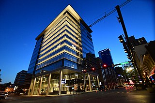
City Center, formerly known as CentrePointe, is a residential, commercial, and retail building in downtown Lexington, Kentucky that opened in 2020. The plan consists of a 12-story office tower incorporating premium luxury condominiums in its top three floors, two hotels, retail spaces and an underground parking garage. The parking garage was completed in 2017.
Indian Hills is a subdivision of Lexington, Kentucky, United States. It is bounded by New Circle Road and Harrodsburg Road. Its southern boundary varies depending on the development rates of it and the neighboring Stonewall neighborhood. Indian Hills is the latest to be built.
Kentucky Proud Park is a baseball stadium in Lexington, Kentucky. It is the home field of the University of Kentucky Wildcats college baseball team. The stadium opened in 2018, with the Wildcats playing their first season there in 2019. It has 2,500 fixed seats, with grass berm seating adding an additional 1,500-plus to the total capacity. Temporary seating can also be added to bring the capacity to 7,000 for NCAA tournament games.
References
- ↑ Berman, Michelle. "The road east new business, new life at the other end of Main." 27 December 1987. Herald-Leader [Lexington]. 9 November 2006.
- ↑ Honeycutt, Valarie. "Projects large and small creating downtown Lexington of the future." 30 November 1986. Herald-Leader [Lexington]. 10 November 2006.
38°02′22″N84°29′24″W / 38.0394°N 84.4900°W
| | This article about a building or structure in Kentucky is a stub. You can help Wikipedia by expanding it. |