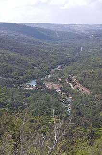
Wooroloo Brook is a watercourse that runs through the Darling Range in Western Australia. It joins the Swan River at Bell's Rapids via the nearby Hundred Foot Falls.
Western Australia is a state occupying the entire western third of Australia. It is bounded by the Indian Ocean to the north and west, and the Southern Ocean to the south, the Northern Territory to the north-east, and South Australia to the south-east. Western Australia is Australia's largest state, with a total land area of 2,529,875 square kilometres, and the second-largest country subdivision in the world, surpassed only by Russia's Sakha Republic. The state has about 2.6 million inhabitants – around 11 percent of the national total – of whom the vast majority live in the south-west corner, 79 per cent of the population living in the Perth area, leaving the remainder of the state sparsely populated.
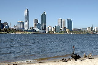
The Swan River is a river in the south west of Western Australia. Its Aboriginal Noongar name is the Derbarl Yerrigan. The river runs through the metropolitan area of Perth, Western Australia's capital and largest city.
The name of the brook is also the name of a number of features and organisations, including the Wooroloo Brook Landcare Group, the Wooroloo Brook Land Conservation District Committee.[1]
The brook alignment had been considered a possible route for the connection of the railway routes occurring at the time of the development of the Trans-Australian Railway.[2][3]
The Trans-Australian Railway crosses the Nullarbor Plain of Australia from Port Augusta in South Australia to Kalgoorlie in Western Australia. It includes a 478-kilometre (297 mi) stretch of dead-straight track, the world's longest, between the 797 km (495 mi) post west of Ooldea and the 1,275 km (792 mi) post west of Loongana.
The locality of Wooroloo is in the upper reaches of the catchment.[4]
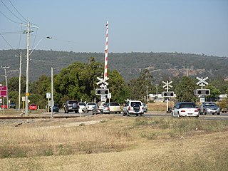
Wooroloo is a town on the outer fringe of the Perth metropolitan area, located off Great Eastern Highway in the eastern part of the Shire of Mundaring. At the 2006 census, Wooroloo had a population of 254.
The catchment runs through the locality of Gidgegannup and the confluence with the Avon River is where the Swan River commences.
Gidgegannup is a township 40 kilometres (25 mi) northeast of Perth, the capital city of Western Australia. The name Gidgegannup comes from a Noongar word meaning "Place where spears are made", and was first recorded by passing surveyors in 1852.
The Avon River is a river in Western Australia. A tributary of the Swan River, the Avon flows 240 kilometres (150 mi) from source to mouth, with a catchment area of 125,000 square kilometres (48,000 sq mi).
Notes
↑ Swan (W.A.: Municipality). Council; Wooroloo Brook Landcare Group (2004), Environmental weeds: Eastern Plains & Hills Region, Wooroloo Brook Land Conservation District Committee and the City of Swan, retrieved 7 June 2018
↑ "WOOROLOO". The Swan Express. XVI, (48). Western Australia. 18 December 1914. p.37. Retrieved 7 June 2018– via National Library of Australia.
Related Research Articles
Greenmount National Park is a national park in the locality of Greenmount, Western Australia, 22 km east of Perth.
John Forrest National Park is a national park in the Darling Scarp, 24 km (15 mi) east of Perth, Western Australia. It was the first national park in Western Australia and the second in Australia after Royal National Park.
Mudgeeraba is a suburb in the Gold Coast hinterland in Queensland, Australia. At the 2011 Australian Census, the suburb recorded a population of 13,204.
The Murray Mallee is the grain-growing and sheep-farming area of South Australia bounded to the north and west by the Murray River, to the east by the Victorian border, and extending about 50 km south of the Mallee Highway.
Darlington, Western Australia, is a locality in the Shire of Mundaring on the Darling Scarp, dissected by Nyaania Creek and north of the Helena River.
The Swan View Tunnel is a former railway tunnel located on the southern side of the Jane Brook valley in the outer Perth suburb of Swan View in the John Forrest National Park on the edge of the Darling Scarp. After its closure as a railway tunnel, it reopened as part of the John Forrest Heritage Trail, a rail trail.
The Railway Reserves Heritage Trail – also on some maps as Rail Reserve Heritage Trail or Rail Reserves Historical Trail, and frequently referred to locally as the Bridle Trail or Bridle Track – is within the Shire of Mundaring in Western Australia.
Crotty is a former gazetted townsite that was located in Western Tasmania, Australia. The township was located on the eastern lower slopes of Mount Jukes, below the West Coast Range, and on the southern bank of the King River. The locality had had a former name of King River
The Queen River, part of the King River catchment, is a minor perennial river located in the West Coast region of Tasmania, Australia.
Bailup is a Western Australian locality and rural residential estate located 62 kilometres (39 mi) north-east of the state capital, Perth, along Toodyay Road. The area is split between the Shire of Toodyay and Shire of Mundaring, the latter of which contains most of the land area.
Toodyay Road is a mostly 2-lane undivided single carriageway in Western Australia, running from the north-eastern Perth suburb of Middle Swan, through Gidgegannup and Bailup, to the Wheatbelt town of Toodyay. It is signposted as State Route 50.
Scott River is a river in the south west of Western Australia, being a tributary to the Blackwood River where it joins just east of Molloy Island. It is partly within the Scott National Park, which is named after the river.
Tregony is a locality in the Southern Downs Region, Queensland, Australia. It is one of the major gateways to the Darling Downs from the Queensland coast.
Daradgee is a town and a locality in the Cassowary Coast Region, Queensland, Australia.. As of the 2016 Australian Census, Daradgee had a population of 74 people.
Fairyland is a rural locality in the Western Downs Region, Queensland, Australia. In the 2016 census, Fairyland had a population of 67 people.
Pyap is a locality in the Riverland region of South Australia. It is on the left (south) bank of the Murray River about 7 km downstream from Loxton. It includes both flat land near the river and higher land away from it. The environment is dry, so vineyards and orchards are irrigated from the river. It lies on the Kingston Road from Loxton, at the junction with the Stott Highway towards Swan Reach.
Woondum is a locality in the Gympie Region, Queensland, Australia.
This page is based on this Wikipedia article Text is available under the CC BY-SA 4.0 license; additional terms may apply. Images, videos and audio are available under their respective licenses.