
The Toronto Islands are a chain of 15 small islands in Lake Ontario, south of mainland Toronto, Ontario, Canada.

St. Lawrence is a neighbourhood located in downtown Toronto, Ontario, Canada. The area, a former industrial area, is bounded by Yonge, Front, and Parliament Streets, and the Canadian National railway embankment. The Esplanade off Yonge St., lined with restaurants, cafés and hotels runs through the middle of the area. In previous times, the area was sometimes referred to as 'St. Lawrence Ward' or more often today as 'St. Lawrence Market', synonymous with the large retail vendor market which is the neighbourhood's focal point. The area is the site of a large city-sponsored housing project of the 1970s, which revitalized an old brownfields area. The boundaries of the St Lawrence Neighbourhood Association and the St Lawrence Market BIA are somewhat larger than those noted above. Both groups have boundaries that extend from Yonge to Parliament Streets and Queen Street East to the rail corridor.

Harbourfront is a neighbourhood on the northern shore of Lake Ontario within downtown Toronto, Ontario, Canada. Part of the Toronto waterfront, Harbourfront extends from Bathurst Street in the west, along Queens Quay, with its ill-defined eastern boundary being either Yonge Street or York Street. Its northern boundary is the Gardiner Expressway. Much of the district was former water lots filled in during the early 1900s to create a larger harbour district. After shipping patterns changed and the use of the Toronto Harbour declined, the area was converted from industrial uses to a mixed-use district that is mostly residential and leisure.

The George Brown College of Applied Arts and Technology is a public, fully accredited college of applied arts and technology with three campuses in downtown Toronto. Like many other colleges in Ontario, George Brown College was chartered in 1966 by the government of Ontario and opened the next year.

Lawrence Heights is a neighbourhood in Toronto, Ontario, Canada. It is located north-west of central Toronto, in the district of North York. The neighbourhood is roughly bounded by Lawrence Avenue to the south, Yorkdale Road to the north, Varna Drive to the east and Dufferin Street to the west. It is part of the greater Yorkdale-Glen Park official Toronto neighbourhood.

Government House was the official residence of the lieutenant governor of Upper Canada and Ontario, Canada. Four buildings were used for this purpose, none of which exist today, making Ontario one of four provinces not to have an official vice-regal residence.

One Yonge Street is a 25-storey office building in Toronto, Ontario, Canada. The building served as the headquarters of Torstar and its flagship newspaper, the Toronto Star, from 1971 to 2022. It is 100 metres tall and built in the International style. It was built as a replacement to the Old Toronto Star Building, which was located at 80 King Street West. That building was torn down to make room for First Canadian Place.

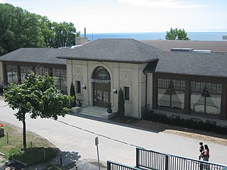
The Bank of Upper Canada Building is a former bank building in Toronto, Ontario, Canada, and one of the few remaining buildings in Toronto that predate the 1834 incorporation of the city. It is located at 252 Adelaide Street East, in the Old Town district. Opened in 1827, in what was then the town of York, the building housed the Bank of Upper Canada until the bank's collapse in 1866. It was then used for school purposes and later for various commercial and industrial purposes before being restored in 1982 as commercial office space. The building has been designated a National Historic Site of Canada since 1977.

The Golden Mile is a commercial district in the Scarborough district of Toronto, Ontario, Canada. Situated along Eglinton Avenue East, east of Victoria Park Avenue, it was one of Canada's first model industrial parks. The original Golden Mile of Industry ran along Eglinton from Pharmacy Avenue east to Birchmount Road.

The Guild Inn, or simply The Guild was a historic hotel in the Guildwood neighbourhood of Scarborough, Toronto, Ontario and was once an artists colony. The surrounding Guild Park and Gardens is notable for a sculpture garden consisting of the rescued facades and ruins of various demolished downtown Toronto buildings such as bank buildings, the old Toronto Star building and the Granite Club. The park is situated on the Scarborough Bluffs with views of Lake Ontario. Guild Park remained open and the refurbishment of the Guild Inn into a facility for social events was completed in May 2017.

The Dominion Public Building is a five-storey Beaux-Arts neoclassical office building built between 1926 and 1935 for the government of Canada at southeast corner of Front and Bay streets in Toronto, Ontario, Canada.

The Toronto Normal School was a teachers college in Toronto, Ontario, Canada. Opened in 1847, the normal school was located at Church and Gould streets in central Toronto, and was a predecessor to the current Ontario Institute for Studies in Education. The Royal Ontario Museum, the Ontario College of Art & Design and the Ontario Agricultural College all originated at the Normal School's campus and the provincial Department of Education was also located there. Officially named St. James Square, the school became known as "the cradle of Ontario's education system". The school's landmark Gothic-Romanesque building was designed by architects Thomas Ridout and Frederick William Cumberland in 1852. The landmark building was demolished in 1963, but architectural elements of the structure remain on the campus of Toronto Metropolitan University.

Flemingdon Park is a neighbourhood in Toronto, Ontario, Canada, located in the city's North York district. It is part of the Don Valley East federal and provincial electoral districts, and Ward 26: Don Valley East (South) municipally. In 2011, its population was 22,205. The average income was $66,784.
Palais Royale is a dance hall in Toronto, Ontario, Canada, located on Lake Shore Boulevard at the foot of Roncesvalles Avenue on Lake Ontario. Originally built as a boat works, it became notable as a night club in the now-defunct Sunnyside Amusement Park, hosting many prominent 'big band' jazz bands. Since the Park's demolition, the building has ceased to be a nightclub, being used for special occasions and concerts. It has recently been remodeled and is in use for special occasions and meetings.

Walnut Hall was a row of four Georgian-style terraced homes in Toronto, Ontario, Canada. Constructed in 1856, it was recognized by both the Government of Canada and the City of Toronto as being of historic significance, but portions of it collapsed and it had to be demolished in 2007 due to neglect. At the time of its demolition, it was Toronto's last remaining complete row of 19th century Georgian townhomes.

St. George was a provincial riding in Ontario, Canada, that returned Members of Provincial Parliament (MPPs) to the Legislative Assembly of Ontario at Queen's Park. It was created in downtown Toronto in 1926 and was merged into the riding of St. George—St. David in 1987. The seat covered much of the city's central core, roughly similar to the current riding of Toronto Centre. At its dissolution it stretched from University Avenue to Parliament Street and from the waterfront north past St. Clair.

Trefann Court is a small neighbourhood in the eastern part of downtown Toronto, Ontario, Canada. It is located on the north side of Queen Street between Parliament Street and River Street. It extends north only a short distance to Shuter St.

The CAA Theatre, formerly the Panasonic Theatre, is a theatre located at 651 Yonge Street in Toronto, Ontario, Canada. It is operated by Mirvish Productions. On December 1, 2017, Mirvish Productions announced a marketing partnership with CAA South Central Ontario, which included renaming the venue that was known as the Panasonic Theatre.

The Heintzman House, also known as Sunnyside Manor Farm, is one of the oldest buildings in Thornhill-Markham, Ontario, where it sits on the crest of Bay Thorn Drive.

Ontario Provincial Police Headquarters is the main administration office for the Ontario Provincial Police. The building is located at 777 Memorial Avenue in Orillia, Ontario. It was completed in 1995 and is the first building constructed specifically to house the OPP headquarters.
