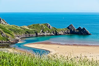
Swansea is a coastal city and the second-largest city of Wales. It forms a principal area, officially known as the City and County of Swansea.

Gower or the Gower Peninsula is in South West Wales and is the most westerly part of the historic county of Glamorgan, Wales. It projects towards the Bristol Channel. In 1956, the majority of Gower became the first area in the United Kingdom to be designated an Area of Outstanding Natural Beauty.

Mumbles is a headland sited on the western edge of Swansea Bay on the southern coast of Wales.

The Bristol Channel is a major inlet in the island of Great Britain, separating South Wales and South West England. It extends from the smaller Severn Estuary of the River Severn to the North Atlantic Ocean. It takes its name from the English city and port of Bristol.

Swansea University is a public research university located in Swansea, Wales, United Kingdom.

New Quay is a seaside town, community and electoral ward in Ceredigion, Wales; it had a resident population of 1,045 at the 2021 census. Located 19 miles (31 km) south-west of Aberystwyth, on Cardigan Bay with a harbour and large sandy beaches, the town lies on the Ceredigion Coast Path and the Wales Coast Path. It remains a popular seaside resort and traditional fishing town, with strong family and literary associations with the poet Dylan Thomas and his play, Under Milk Wood.

South Wales is a loosely defined region of Wales bordered by England to the east and mid Wales to the north. Generally considered to include the historic counties of Glamorgan and Monmouthshire, south Wales extends westwards to include Carmarthenshire and Pembrokeshire. In the western extent, from Swansea westwards, local people would probably recognise that they lived in both south Wales and west Wales. The Brecon Beacons National Park covers about a third of south Wales, containing Pen y Fan, the highest British mountain south of Cadair Idris in Snowdonia.

Rhossili is both a small village and a community on the southwestern tip of the Gower Peninsula in Wales. It is within the first Area of Outstanding Natural Beauty in the United Kingdom. The village has a community council and is part of the Gower parliamentary constituency, and the Gower electoral ward. At the 2011 census, the population was 278. The community includes the hamlet of Middleton.

Moelfre ( ) is a village, a community and, until 2012, an electoral ward on the north-east coast of the Isle of Anglesey in Wales. The community area covers the village and harbour, and several smaller, dispersed settlements. It includes six scheduled Iron Age hut groups and many other sites of archaeological interest. The harbour was formerly a local fishing port; a lifeboat station has been based here since 1854. Among many shipwrecks off the coast was that of the Royal Charter in 1859. Near the modernised lifeboat station is the RNLI Seawatch Centre. The coastline includes a rocky headland north of the village and a large sandy beach at Lligwy Bay, both traversed by the Anglesey Coastal Path. The 2011 census measured the village population as 710. It was estimated at 614 in 2019.

The Bishop Gore School is a secondary school in Swansea in Wales, founded on 14 September 1682 by Hugh Gore (1613–1691), Bishop of Waterford and Lismore. It is situated in Sketty, close to Singleton Park and Swansea University. In December 2013 the school was ranked in the second highest of five bands by the Welsh Government, based on performance in exams, value added performance, disadvantaged pupils' performance, and attendance.

Sker Point is a headland in Bridgend County Borough on the South Wales coast between Port Talbot and Porthcawl. It marks the south end of Kenfig Sands. The placename Sker is of Old Norse origin, and means skerry.

Mumbles is a district of Swansea, Wales, located on the south-east corner of the unitary authority area. It is also a local government community using the same name. At the 2001 census the population was 16,774, reduced slightly to 16,600 at the 2011 Census. The district is named after the headland of Mumbles, located on its south-east corner.

The Mumbles Lifeboat Station is at Mumbles Pier, located at the south-western corner of Swansea Bay, near the village of Mumbles, within the city and county of Swansea, in the historic county of Glamorgan, Wales.

Horton and Port Eynon Lifeboat Station is located at Horton Beach, just off Underhill Lane in the village of Horton, on the south coast of the Gower Peninsula, approximately 14 miles (23 km) west of Swansea.

The Gower and Swansea Bay Coast Path is part of the Wales Coast Path, an 870-mile (1,400 km) long-distance walking route around the whole coast of Wales that opened in 2012. The Gower and Swansea Bay section is 97 miles (156 km) in length, running along the coast of the Gower Peninsula from Loughor, Swansea to Kenfig Dunes near Port Talbot, South Wales. The number of people using the Wales Coast Path in the Swansea local authority area was 349,333.
The geology of the Gower Peninsula in South Wales is central to the area's character and to its appeal to visitors. The peninsula is formed almost entirely from a faulted and folded sequence of Carboniferous rocks though both the earlier Old Red Sandstone and later New Red Sandstone are also present. Gower lay on the southern margin of the last ice sheet and has been a focus of interest for researchers and students in that respect too. Cave development and the use of some for early human occupation is a further significant aspect of the peninsula's scientific and cultural interest.

The coastline of Wales extends from the English border at Chepstow westwards to Pembrokeshire then north to Anglesey and back eastwards to the English border once again near Flint. Its character is determined by multiple factors, including the local geology and geological processes active during and subsequent to the last ice age, its relative exposure to or shelter from waves, tidal variation and the history of human settlement and development which varies considerably from one place to another. The majority of the coast east of Cardiff in the south, and of Llandudno in the north, is flat whilst that to the west is more typically backed by cliffs. The cliffs are a mix of sandstones, shales and limestones, the erosion of which provides material for beach deposits. Of the twenty-two principal areas which deliver local government in Wales, sixteen have a coastline, though that of Powys consists only of a short section of tidal river some distance from the open sea. Its length has been estimated at 1,680 miles (2,700 km).
Events from the year 2025 in Wales.


