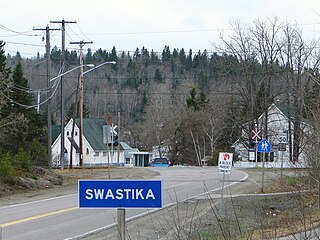
Swastika is a small community founded around a mine site in Northern Ontario, Canada in 1908. Today it is within the municipal boundaries of Kirkland Lake, Ontario. It has frequently been noted on lists of unusual place names.
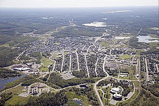
Kirkland Lake is a town and municipality in Timiskaming District of Northeastern Ontario. The 2016 population, according to Statistics Canada, was 7,981.

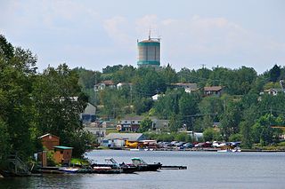
Cobalt is a town in Timiskaming District, Ontario, Canada. It had a population of 1,118 at the 2016 Census. The population is now closer to 943.

Larder Lake is an incorporated municipal township and eponymous constituent dispersed rural community in Timiskaming District in Northeastern Ontario, Canada. It is located along Ontario Highway 66 and Ontario Highway 624 at the north-western part of the lake bearing the same name. The area of the township is 229.65 km2 (88.67 sq mi) and includes the geographic townships of Hearst, McVittie and Skead.

Wawa is a township in the Canadian province of Ontario in the Algoma District. Formerly known as the Township of Michipicoten, named after a nearby river of that name, the township was officially renamed in 2007 for its largest and best-known community of Wawa, located on the western shores of Wawa Lake.
William Henry Wright was a Canadian prospector.

Unorganized Thunder Bay District is an unorganized area in northwestern Ontario, Canada in Thunder Bay District. It comprises all parts of the district that are not part of an incorporated municipality or a First Nations reserve.

The Hollinger Gold Mine was discovered on October 9, 1909, by Benny Hollinger, who found the gold-bearing quartz dike that later became known as Hollinger Mines. With his friend, professional prospector Alex Gillies, Hollinger had travelled to the Porcupine region in the wake of the Wilson expedition, which had recently discovered the future Dome Mine site. Hollinger and Gillies staked three claims each, and one for their former partner, Bernard "Barney" P. McEnaney, who had been unable to join them due to severe sciatica.

Dome Mine is situated in the City of Timmins, Ontario, Canada; and was developed during the Porcupine Gold Rush. Last operated by Canadian company Goldcorp, before it became a subsidiary of American company Newmont, it is one of three mines owned by Newmont in the Porcupine district in and around Timmins.
Red Lake is a municipality with town status in the Canadian province of Ontario, located 535 km (332 mi) northwest of Thunder Bay and less than 100 km (62 mi) from the Manitoba border. The municipality consists of six small communities—Balmertown, Cochenour, Madsen, McKenzie Island, Red Lake and Starratt-Olsen—and had a population of 4,107 people in the Canada 2016 Census.

The McIntyre mine is an abandoned underground gold mine in Schumacher, Ontario, Canada, which has earned a place in Canadian mining history as one of the nation's most important mines. Its iconic headframe, located near downtown Timmins, has come to represent the entire Porcupine Gold Rush. The McIntyre also yielded a considerable amount of copper over its life.
The Golden Giant Mine is a closed underground gold mine in the Hemlo mining camp in Canada, located north of Lake Superior, midway between Sault Ste. Marie and Thunder Bay, Ontario near the town of Manitouwadge.

Matachewan is a township in Timiskaming, Northeastern Ontario, Canada, located at the end of Ontario Highway 66 along the Montreal River. The name is derived from the Cree word for "meeting of the currents".

The Porcupine Gold Rush was a gold rush that took place in Northern Ontario starting in 1909 and developing fully by 1911. A combination of the hard rock of the Canadian Shield and the rapid capitalization of mining meant that smaller companies and single-man operations could not effectively mine the area, as opposed to earlier rushes where the gold could be extracted through placer mining techniques. Although a number of prospectors made their fortune, operations in the area are marked largely by the development of larger mining companies, and most people involved in the mining operations were their employees.

Shining Tree is an unincorporated community in the Canadian province of Ontario, located on Highway 560 in the Sudbury District. It lies on the east of West Shining Tree Lake.
The Cobalt silver rush was a silver rush in Ontario, Canada that began in 1903 when huge veins of silver were discovered by workers on the Temiskaming and Northern Ontario Railway (T&NO) near the Mile 103 post. By 1905 a full-scale silver rush was underway, and the town of Cobalt, Ontario sprang up to serve as its hub. By 1908 Cobalt produced 9% of the world's silver, and in 1911 produced 31,507,791 ounces of silver. However, the good ore ran out fairly rapidly, and most of the mines were closed by the 1930s. There were several small revivals over the years, notably in World War II and again in the 1950s, but both petered out and today there is no active mining in the area. In total, the Cobalt area mines produced 460 million ounces of silver.

Keeley-Frontier Mine is a large abandoned mine in the ghost town of Silver Centre, Northeastern Ontario, Canada. It consists of two underground mines that were sunk 1,455 ft (443 m) below the surface. Keeley Mine was discovered in 1907 while Frontier Mine was constructed in 1921. The 8th level of the Keeley Mine connected with the 6th level of the Frontier Mine in 1962, creating the two compartment Keeley-Frontier Mine. In 1965, Keeley-Frontier Mine closed with a total production of 19,000,000 oz (540,000,000 g) of silver, 3,300,000 lb (1,500,000 kg) of cobalt, 27,000 lb (12,000 kg) of nickel and 10,000 lb (4,500 kg) of copper.
The Fort Knox Gold Mine is an open pit gold mine, 9 mi (14 km) east of Fox in the Fairbanks mining district of Alaska. It is owned and operated by Toronto-based Kinross Gold. Originally staked in 1913, after very minor mining at the location the property sat idle until being restaked in 1980. Following the initial exploration discovery in 1987, in 1992 the project was purchased by Amax Gold, which brought the mine to production. Amax Gold merged with Kinross Gold in 1998.
The Lake Shore Mine is a gold mine located in Kirkland Lake, Ontario. In July 1912, Harry Oakes staked claims L-2605-6 which were in the lake itself and had reverted for non-performance of work. On September 6, 1912, he registered the transfer of claim L-1557 that Melville McDougall had staked for Oakes previously. On September 23, 1911, Harry Oakes registered the transfer of claim T-16635 from George Minaker and named the property Lake Shore. In production from 1918 to 1965, the mine produced almost 8.5 million ounces of gold and represented over a third of the gold produced in the entire camp. The closure of the mine once known as the 'Jewel box of North America' in 1965 was the result of a number of factors including a declining ore reserve picture, unfruitful exploration, increased water inflow into the workings from other closed mines exceeding pump capacity and unstable workings at depth, The mill operated until 1968 re-milling historic tailings. The surface plant was demolished in 1969. The mine reopened in 1981 by new owners LAC Minerals and operated intermittently as an exploration project along with pillar recovery and tailings processing with material processed at the nearby Macassa Mill. Activity ceased in 1987 and the property has followed the chain of ownership of the Macassa mine.

The Kerr–Addison Mine is an abandoned Canadian gold mine in the Kearns area of McGarry, Ontario. In 1960, the mine was the largest producer of gold in North America. The mine produced the second most gold overall in North America, with the Homestake Mine being the leader.
