Related Research Articles

The Darling Scarp, also referred to as the Darling Range or Darling Ranges, is a low escarpment running north–south to the east of the Swan Coastal Plain and Perth, Western Australia. The escarpment extends generally north of Bindoon, to the south of Pemberton. The adjacent Darling Plateau goes easterly to include Mount Bakewell near York and Mount Saddleback near Boddington. It was named after the Governor of New South Wales, Lieutenant-General Ralph Darling.

The Division of Canning is an Australian Electoral Division in Western Australia.

The Helena River is a tributary of the Swan River in Western Australia. The river rises in country east of Mount Dale and flows north-west to Mundaring Weir, where it is dammed. It then flows west until it reaches the Darling Scarp.

North Dandalup is a small town in the Peel region of Western Australia along the South Western Highway between Serpentine and Pinjarra. Its local government area is the Shire of Murray. At the 2011 census, North Dandalup had a population of 346.

Bedfordale is a semi-rural suburb in the south-east of Perth, Western Australia, located within the City of Armadale. Located approximately 40 km from Perth in the Darling Range, some of the local attractions include Churchman Brook Dam, Wungong Dam and the Elizabethan Pub. The area is popular for hiking and cycling. Being close to Armadale railway station provides easy access to the city by train.

Wungong, pronounced is a semi-rural south-eastern suburb of Perth, Western Australia, located midway between Armadale and Byford and located in the local government area of the City of Armadale.
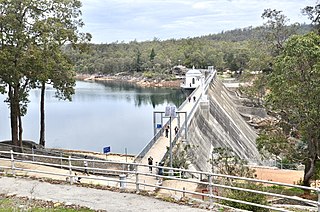
Mundaring Weir is a concrete gravity dam located 39 kilometres (24 mi) from Perth, Western Australia in the Darling Scarp. The dam and reservoir form the boundary between the suburbs of Reservoir and Sawyers Valley. The dam impounds the Helena River.

The Goldfields Water Supply Scheme is a pipeline and dam project that delivers potable water from Mundaring Weir in Perth to communities in Western Australia's Eastern Goldfields, particularly Coolgardie and Kalgoorlie. The project was commissioned in 1896 and completed in 1903.

South Dandalup River is a river in the South West region of Western Australia.

Swan View railway station, Perth was a railway station of significance on the Eastern Railway in Western Australia. In all working timetables during the operation of this line, the station was the point of control for the Swan View Tunnel.
The Public Works Department (PWD) was the State Government Agency of Western Australia, which was charged with providing and maintaining public infrastructure such as dams, water supplies, schools, hospitals, harbours and other public buildings. The department is no longer operational, having its responsibilities reassigned to other State Government Departments and corporate entities since 1985.
Bickley Pumpback Dam, known also as the Lower Bickley Brook reservoir, is located in Perth, Western Australia.
Araluen Pumpback Dam is a minor dam on the Canning River. Water stored in the dam can be pumped back into Canning Dam where the water is treated and distributed through the metropolitan trunk main distribution system.
The Canning Tunnel is a tunnel that originates just west of Canning Dam and runs for approximately 5.6 kilometres (3.5 mi) through the granite Darling Scarp to the western portal trunk main in Soldiers Road about 1 kilometre (0.62 mi) south of the Brookton Highway intersection. It measures 2.7 by 2.7 metres. A separate 910-millimetre (36 in) pipeline from Canning Dam remains. The tunnel is more than 120 metres (390 ft) below ground level at its deepest point.

Churchman Brook Dam is an earthfill embankment dam approximately 30 kilometres (20 mi) south east of Perth, Western Australia in the City of Armadale. The reservoir is a water source for Perth.

The Fortescue River is an ephemeral river in the Pilbara region of Western Australia. It is the third longest river in the state.

The Canning Contour Channel is a 16 kilometres (9.9 mi) series of man-made concrete channels and steel and cast-iron pipelines in the Darling Scarp in Western Australia constructed between July 1935 and December 1936. The project was a Depression era public works scheme to carry potable water from just below Canning Dam through the hills around and above Roleystone and Kelmscott to a screening, fluoridation and pumping station near Gosnells by following the natural contours of the Canning Valley—hence it was entirely gravity-fed. Where a tributary valley needed to be crossed, suspended or siphoning pipelines were used. From Gosnells, the water entered the city's pipeline distribution system.

The Araluen-Wungong Important Bird Area is a 123 km2 tract of land in the Darling Ranges on the south-eastern fringe of the city of Perth, Western Australia. The name derives from the Araluen Botanic Park within the Important Bird Area (IBA), and the adjacent suburb of Wungong. It is an important site for black cockatoos.

The Airport line is a suburban railway line in Perth, Western Australia, operated by the Public Transport Authority as part of the Transperth system. The Airport line interlines with the Fremantle and Midland lines, passing through the Perth central business district before branching off at Bayswater to travel through the 8.5-kilometre (5.3 mi) Forrestfield–Airport Link tunnel, which serves Perth Airport and surrounding suburbs.
References
- ↑ Cunningham, S & Marcos, GW & Mather, RP (1984). The Wungong Tunnel, Metropolitan Water Authority, Perth, Geology and Construction. In Fifth Australian Tunnelling Conference: State of the Art in Underground Development and Construction; Preprints of Papers. 142-152
- ↑ Wungong Tunnel Railways Light Railways issue 74 October 1981 pagres 38-40
32°11′01″S116°01′13″E / 32.183517°S 116.020208°E
| | This Perth-related article is a stub. You can help Wikipedia by expanding it. |
| | This article about an Australian building or structure is a stub. You can help Wikipedia by expanding it. |