See also
| This disambiguation page lists articles associated with the title Wychwood. If an internal link led you here, you may wish to change the link to point directly to the intended article. |
Wychwood , or Wychwood Forest, is an area in rural Oxfordshire, England.
Wychwood may also refer to:
| This disambiguation page lists articles associated with the title Wychwood. If an internal link led you here, you may wish to change the link to point directly to the intended article. |

Witney is a historic market town on the River Windrush, 12 miles (19 km) west of Oxford in Oxfordshire, England.

Spelsbury is a village and civil parish about 1.5 miles (2.4 km) north of Charlbury and about 4 miles (6.4 km) southeast of Chipping Norton, Oxfordshire. The village is on a narrow hill between the Coldron and Taston brooks overlooking the River Evenlode and the ancient Wychwood Forest to the south. The 2011 Census recorded the parish's population as 305.

Wychwood or Wychwood Forest is a 501.7-hectare (1,240-acre) biological Site of Special Scientific Interest north of Witney in Oxfordshire. It is also a Nature Conservation Review site, Grade 1, and an area of 263.4 hectares is a National Nature Reverse The site contains a long barrow dating to the Neolithic period, which is a Scheduled Monument
Ascott-under-Wychwood is a village and civil parish in the Evenlode valley about 4.5 miles (7 km) south of Chipping Norton, Oxfordshire, England. The 2011 Census recorded the parish's population as 560.

Milton-under-Wychwood is a village and civil parish about 4 miles (6.4 km) north of Burford, Oxfordshire, just off the A361 road between Burford and Chipping Norton. The 2011 Census recorded the parish's population as 1,648.

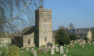
Shipton-under-Wychwood is a village and civil parish in the Evenlode valley about 4 miles (6.4 km) north of Burford, Oxfordshire. The village is one of three named after the ancient forest of Wychwood. The others are Milton-under-Wychwood immediately to the west of the village and Ascott-under-Wychwood about 1.5 miles (2.4 km) to the east. The 2011 Census recorded Shipton-under-Wychwood's parish population as 1,244.

Bracondale Hill, also known as Hillcrest, is a residential neighbourhood of Toronto, Ontario, Canada. Annexed by the old City of Toronto in 1909 and developed in 1911 from the Turner estate, Bracondale Hill is on the eastern border of West End Toronto; neighbouring Midtown, stretching above Davenport Road and below St. Clair Avenue West.
Leafield is a village and civil parish about 4 miles (6.4 km) northwest of Witney in West Oxfordshire. The parish includes the hamlet of Langley, 1 mile (1.6 km) west of Leafield village. The 2011 Census recorded the parish's population as 945.

Humewood-Cedarvale is an area of Toronto, Ontario, Canada, consisting of the wealthy Cedarvale in the north and the upper middle class Humewood in the south, divided by Vaughan Road and Cedarvale Ravine. The neighbourhood is bordered by Bathurst Street on the east, Eglinton Avenue to the north, Arlington Avenue to the west, and St. Clair Avenue to the south. Humewood is also known as "The Woods" because of its many streets that have names ending with "-wood", including Wychwood, Humewood, Cherrywood, Valewood, Maplewood, Wellwood, Kenwood, and Pinewood. The neighbourhood's main commercial area is along St. Clair Ave. W. and is referred to as Hillcrest Village.

Fifield is a village and civil parish about 4 miles (6.4 km) north of Burford in Oxfordshire. The western boundary of the parish forms part of the county boundary with Gloucestershire. The 2011 Census recorded the parish's population as 240.

Wychwood Park is a neighbourhood enclave and former gated community in Toronto, Ontario, Canada. It is located north of Davenport Road and just west of Bathurst Street, within the larger neighbourhood of Bracondale Hill.

Ascott d'Oyley is a village in Oxfordshire, England.

Idbury is a village and civil parish in the Cotswold Hills in Oxfordshire, about 4 1⁄2 miles (7 km) southeast of Stow-on-the-Wold in neighbouring Gloucestershire. The parish includes the hamlets of Bould and Foscot. The 2011 Census recorded the parish's population as 240.

Toronto—St. Paul's is a provincial electoral district in Ontario, Canada, that has been represented in the Legislative Assembly of Ontario since 1999. Before the 2018 election, it was known simply as St. Paul's.
The Oxfordshire Way is a long-distance walk in Oxfordshire, England, with 6 miles in Gloucestershire and very short sections in Buckinghamshire. The path links with the Heart of England Way and the Thames Path.

The Wychwood Way is a waymarked long-distance footpath in southern England in the United Kingdom.

Lyneham is a village and civil parish about 5 miles (8 km) southwest of Chipping Norton, Oxfordshire. It is bounded to the southwest by the River Evenlode, to the southeast by the A361 road linking Chipping Norton and Burford, and on other sides by field boundaries. The 2011 Census recorded the parish's population as 153.

Wychwood Barns is a community centre and park in the Bracondale Hill area of Toronto. The converted heritage building was built as a streetcar maintenance facility in 1913. It now contains artist housing and studios, public green space, a greenhouse, a farmer's market, a beach volleyball court, a theatre, a dog run, and office space for many local community groups. The site is a total of 5,574 square metres.
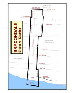
Bracondale was a provincial electoral district in Toronto, Ontario, Canada. It was represented in the Legislative Assembly of Ontario from 1926 to 1967. The constituency got its name from an old Toronto suburb called Bracondale, that was annexed by Toronto in 1909. Its most notable event was electing one of the first two women Members of the Provincial Parliament (MPP) to share the title "first-woman MPP" in 1943 when Rae Luckock was elected. In 1965, Bracondale's MPP, Joseph Gould, died in office sparking the final election held in the constituency. George Ben won the by-election, and became the constituency's last MPP. It was abolished for the 1967 Ontario provincial election, and redistributed into the Dovercourt and Bellwoods constituencies. As of 2012, the current electoral districts of Davenport, St. Paul's and Trinity–Spadina encompass this historic riding.