
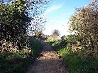
The Wychwood Way is a waymarked long-distance footpath in southern England in the United Kingdom.
The Wychwood Way is a waymarked long-distance footpath in southern England in the United Kingdom.
The route runs for 59.5 km (37 mi).
The Wychwood Way runs through the ancient Royal Forest of Wychwood in West Oxfordshire.
It is a circular walk and starts from Woodstock, Oxfordshire passing through Stonesfield, Chadlington, Ascott-under-Wychwood, Leafield, Ramsden, North Leigh, East End, Oxfordshire, incorporates part of the Roman road of Akeman Street and the older route of the Saltway crossing Blenheim Park and links in with the Oxfordshire Way.

The Cotswold Line is an 86+1⁄2-mile (139.2 km) railway line between Oxford and Hereford in England.

The E2 European long distance path or E2 path is a 4850 km (3010-mile) series of long-distance footpaths that is intended to run from Galway in Ireland to France's Mediterranean coast and currently runs through Northern Ireland, Scotland, England, Belgium, Luxembourg and France, with an alternative midsection equally designated via the Netherlands and east coast of England. It is one of the network of European long-distance paths.

Wychwood or Wychwood Forest is a 501.7-hectare (1,240-acre) biological Site of Special Scientific Interest north of Witney in Oxfordshire. It is also a Nature Conservation Review site, Grade 1, and an area of 263.4 hectares is a national nature reserve The site contains a long barrow dating to the Neolithic period, which is a scheduled monument
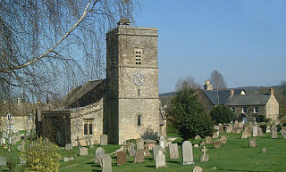
Ascott-under-Wychwood is a village and civil parish in the Evenlode valley about 4.5 miles (7 km) south of Chipping Norton, Oxfordshire, England. The 2011 Census recorded the parish's population as 560.

Shipton-under-Wychwood is an English village and civil parish in the Evenlode valley about 4 miles (6.4 km) north of Burford, Oxfordshire. The village is one of three named after the ancient forest of Wychwood. The others are Milton-under-Wychwood immediately to the west of the village and Ascott-under-Wychwood about 1.5 miles (2.4 km) to the east. The 2011 Census recorded Shipton-under-Wychwood's parish population as 1,244.

Banbury Road is a major arterial road in Oxford, England, running from St Giles' at the south end, north towards Banbury through the leafy suburb of North Oxford and Summertown, with its local shopping centre. Parallel and to the west is the Woodstock Road, which it meets at the junction with St Giles'. To the north, Banbury Road meets the Oxford Ring Road at a roundabout. The road is designated the A4165. Prior to the building of the M40 motorway extension in 1990, the road formed part of the A423 from Maidenhead to Coventry.

The Great Glen Way is a long distance path in Scotland. It follows the Great Glen, running from Fort William in the southwest to Inverness in the northeast, covering 125 kilometres (78 mi). It was opened in 2002, and is designated as one of Scotland's Great Trails by NatureScot. The Great Glen Way is generally walked from southwest to northeast to follow the direction of the prevailing wind. It can be walked in 5–7 days, or cycled in 2–3 days. The trail is maintained and improved by the Great Glen Ways partnership, which consists of Highland Council, Scottish Canals and Forestry and Land Scotland. About 30,000 people use the path every year, of whom about 4,500 complete the entire route.

Swan's Way is a long distance bridle route and footpath in Northamptonshire, Buckinghamshire and Oxfordshire, England. It runs 65 miles (105 km) from Salcey Forest, Northamptonshire to Goring-On-Thames, Oxfordshire. Although designed for horseriders by riders, it is a multi-use trail also available to walkers and cyclists.
Leafield is a village and civil parish about 4 miles (6.4 km) northwest of Witney in West Oxfordshire. The parish includes the hamlet of Langley, 1 mile (1.6 km) west of Leafield village. The 2011 Census recorded the parish's population as 945. The village is 635 feet (194 m) above sea level in the Cotswold Hills. It was the highest point in Oxfordshire until the 1974 county boundary changes enlarged the county.

Fifield is a village and civil parish about 4 miles (6.4 km) north of Burford in Oxfordshire. The western boundary of the parish forms part of the county boundary with Gloucestershire. The 2011 Census recorded the parish's population as 240.
Old Chalford is a hamlet in Enstone civil parish, about 2 miles (3 km) east of Chipping Norton, Oxfordshire.
The Sabrina Way is a waymarked long-distance footpath and bridleway in England.
The Celtic Way is a long-distance walk from West Wales, through South Wales and into Wessex and the West of England in the United Kingdom. The route is 725-mile-long (1,167 km) and visits more than one hundred pre-historic sites through its route.
The Oxfordshire Way is a long-distance walk in Oxfordshire, England, with 6 miles in Gloucestershire and very short sections in Buckinghamshire. The path links with the Heart of England Way and the Thames Path.
The Chiltern Way is a waymarked long-distance footpath in the Chiltern Hills of southern England. It was created by the Chiltern Society as a millennium project.

Ramsden is a village and civil parish about 3+1⁄2 miles (5.6 km) north of Witney in West Oxfordshire. The 2011 Census recorded the parish's population as 342.

Lyneham is a village and civil parish about 5 miles (8 km) southwest of Chipping Norton, Oxfordshire. It is bounded to the southwest by the River Evenlode, to the southeast by the A361 road linking Chipping Norton and Burford, and on other sides by field boundaries. The 2011 Census recorded the parish's population as 153.
The Macmillan Way is a long-distance footpath in England that links Boston, Lincolnshire to Abbotsbury in Dorset. The route's distance is 290 miles (470 km). It is promoted to raise money for the charity Macmillan Cancer Relief.
Wychwood, or Wychwood Forest, is an area in rural Oxfordshire, England.