
The following is an alphabetical list of articles related to the Canadian province of British Columbia.

The Tsilhqotʼin or Chilcotin are a North American tribal government of the Athabaskan-speaking ethnolinguistic group that live in what is now known as British Columbia, Canada. They are the most southern of the Athabaskan-speaking Indigenous peoples in British Columbia.
The Chilcotin region of British Columbia is usually known simply as "the Chilcotin", and also in speech commonly as "the Chilcotin Country" or simply Chilcotin. It is a plateau and mountain region in British Columbia on the inland lee of the Coast Mountains on the west side of the Fraser River. Chilcotin is also the name of the river draining that region. In the language of the Chilcotin people their name and the name of the river means "people of the red ochre river"

The Chilcotin River /tʃɪlˈkoʊtɪn/ located in Southern British Columbia, Canada is a 241 km (150 mi) long tributary of the Fraser River. The name Chilcotin comes from Tŝilhqot’in, meaning "ochre river people," where ochre refers to the mineral used by Tŝilhqot’in Nation and other Indigenous communities as a base for paint or dye. The Chilcotin River, Chilko River and Lake, and Taseko River and Lake make up the Chilcotin River watershed. This 19,200 km2 (7,400 sq mi) watershed drains the Chilcotin Plateau which reaches north to south from the Nechako Plateau to Bridge River county and east to west from Fraser River to the Coast Mountains. It is also one of twelve watersheds that make up the Fraser River Basin. Made up of seven major tributaries, Chilcotin River starts northeast of Itcha Mountain, flowing southeast until it joins the Fraser River south of Williams Lake, 22 km (14 mi) upstream from Gang Ranch.
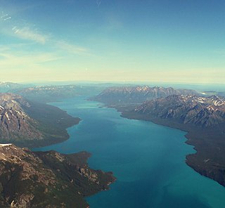
Tŝilhqox Biny, known as Chilko Lake, is a 180 km2 lake in west-central British Columbia, at the head of the Chilko River on the Chilcotin Plateau. The lake is about 65 km long, with a southwest arm 10 km long. It is one of the largest lakes by volume in the province because of its great depth, and the largest above 1,000 m in elevation. It and Harrison Lake are the largest lakes in the southern Coast Mountains.

The Chilko River is a 75-kilometre-long (47 mi) river in the Chilcotin District of the Central Interior of British Columbia, Canada, flowing northeast from Chilko Lake to the Chilcotin River. Its main tributary is the Taseko River.

Tŝ’ilʔoŝ, also known as Mount Tatlow, is one of the principal summits of the Chilcotin Ranges subdivision of the Pacific Ranges of the Coast Mountains of southern British Columbia. Standing on an isolated ridge between the lower end of Chilko Lake and the Taseko Lakes, it is 3,063 m (10,049 ft) in elevation.

The Homathko River is one of the major rivers of the southern Coast Mountains of the Canadian province of British Columbia. It is one of the few rivers that penetrates the range from the interior Chilcotin Country to the coastal inlets of the Pacific Ocean. The Homathko River reaches the sea at the head of Bute Inlet, just west of the mouth of the Southgate River.

Tsʼilʔos Provincial Park is a provincial park in British Columbia, Canada. Tsʼilʔos is the official BC Parks designation for this provincial park, though sometimes it is written as "Ts'il-os", "Ts'yl-os", or "Tsylos". The "ʔ" in the name represents a glottal stop.
The High Bar First Nation is a First Nations government of the Secwepemc (Shuswap) Nation, located in the Fraser Canyon-Cariboo region of the Central Interior of the Canadian province of British Columbia. It was created when the government of the then-Colony of British Columbia established an Indian reserve system in the 1860s. It is one of three Secwepemc bands that is not a member of either the Shuswap Nation Tribal Council or the Northern Shuswap Tribal Council. The High Bar people are also partly Tsilhqot'in and have links with some Chilcotin First Nations.
The Carrier-Chilcotin Tribal Council is a First Nations tribal council located in the Chilcotin District of the Central Interior of the Canadian province of British Columbia, and also on the Fraser River near the city of Quesnel. It consists of three Carrier bands and one Tsilhqot'in band. The other Tsilhqot'in bands belong to the Tsilhqot'in National Government. Most other Carrier bands are either unaffiliated or belong to the Carrier-Sekani Tribal Council. The Tribal Council's offices are in Williams Lake.
The Tl'esqox First Nation is a Tsilhqot'in community located west of the Fraser Canyon in the Chilcotin region of the Canadian province of British Columbia. It is a member of the Carrier-Chilcotin Tribal Council, which includes both Tsilhqot'in and Carrier (Dakelh) communities.
ʔEsdilagh is a First Nation community in the North Cariboo region of British Columbia, Canada. It is the smallest of the six member communities that form the Tsilhqot'in National Government. Formerly, the people of this region were known as ʔElhdaqox-t'in, the people of the Sturgeon River. Today, the community goes by the name ʔEsdilagh, which in Tŝilhqot'in language means peninsula.
The Stone First Nation or Yunesit'in First Nation is a band government of the Yunesit'in subgroup of the Tsilhqot'in people, whose territory is the Chilcotin District in the western Central Interior region of the Canadian province of British Columbia. It is a member of the Tsilhqot'in Tribal Council. The people of the Stone First Nation are known as the Yunesit'in in the Chilcotin language.
The Xeni Gwet'in, also known as the Stone Chilcotin, are a First Nations people whose traditional territory is located in the southern Chilcotin District of the Canadian province of British Columbia, on the inland flank of the Coast Mountains west of the Fraser River. They are a subgroup of the Tshilhqot'in people and are also known as the Stoney Chilcotin, and reside in the area of Nemaia Valley, an unincorporated settlement and Indian Reserve community far off Highway 20 between Chilko and Taseko Lakes.
Nemaiah Valley, also spelled Nemiah Valley and Nemaia Valley, is an unincorporated locality and First Nations reserve and ranching community between Chilko Lake and the Taseko Lakes in the Chilcotin District of the Central Interior of British Columbia.
The Tsilhqot'in National Government (TNG), is the official First Nations government serving the Tsilhqot'in Nation. Their office is located in Williams Lake, British Columbia, Canada. The member communities represented by TNG are ʔEsdilagh, Tsi Del Del, Yunesit'in, Tl'etinqox, Xeni Gwet'in, and Tl'esqox. Tl'esqox also belongs to the Carrier-Chilcotin Tribal Council, as does Ulkatcho - a community with both Dakelh (Carrier) & Tsilhqot'in heritage. TNG was established in 1989.

Tatlayoko Lake is a lake on the Homathko River in the western Chilcotin District of the Central Interior of British Columbia, Canada, located on a north-south axis just upstream of the entrance of the series of canyons of the Homathko, including the Great Canyon of the Homathko, on its route to the sea at the head of Bute Inlet. The community of Tatlayoko Lake, British Columbia is located at its northern end.
The lack of treaties between the First Nations of British Columbia (BC) and the Canadian Crown, is a long-standing problem that has become a major issue in recent years. In 1763, the British Crown declared that only it could acquire land from First Nations through treaties. Historically only two treaties were signed with the First Nations of British Columbia. The first of which was the Douglas Treaties, negotiated by Sir James Douglas with the native people of southern Vancouver Island from 1850-1854. The second treaty, Treaty 8, signed in 1899 was part of the Numbered Treaties that were signed with First Nations across the Prairie regions. British Columbian Treaty 8 signatories are located in the Peace River Country or the far North East of BC. For over nine decades no more treaties were signed with First Nations of BC; many Native people wished to negotiate treaties, but successive BC provincial governments refused until the 1990s. A major development was the 1997 decision of the Supreme Court of Canada in the Delgamuukw v. British Columbia case that Aboriginal title still exists in British Columbia and that when dealing with Crown land, the government must consult with and may have to compensate First Nations whose rights are affected.

Tsilhqot'in Nation v British Columbia is a landmark decision of the Supreme Court of Canada that established Aboriginal land title for the Tsilhqot'in First Nation, with larger effects. As a result of the landmark decision, provinces cannot unilaterally claim a right to engage in clearcut logging on lands protected by Aboriginal title; they must engage in meaningful consultation with the title holder before they proceed. Although the Aboriginal title holder does not have to consent to the activity, meaningful consultation is required before infringement of the right can take place.