Moor or Moors may refer to:

The Muscogee, also known as the Mvskoke, Muscogee Creek, and the Muscogee Creek Confederacy, are a group of related Indigenous peoples of the Southeastern Woodlands in the United States of America. Their historical homelands are in what now comprises southern Tennessee, much of Alabama, western Georgia and parts of northern Florida.
Creek mythology is related to a Muscogee tribe who are originally from the southeastern United States, also known by their original name Mvskoke, the name they use to identify themselves today. Mvskoke is their name in traditional spelling. Modern Muscogees live primarily in Oklahoma, Alabama, Georgia, and Florida. Their language, Mvskoke, is a member of the Eastern branch of the Muskogean language family. The Seminole are close kin to the Mvskoke and speak an Eastern Muskogean language as well. The Muscogee were considered one of the Five Civilized Tribes. After the Creek War many of the Muscogee escaped to Florida to create the Seminole.

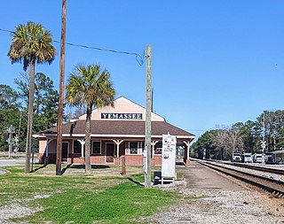
Yemassee is a small Lowcountry town in Beaufort and Hampton counties in the U.S. state of South Carolina. The population was 1,027 at the 2010 census. Yemassee is near the borders of Colleton and Jasper counties. The town is divided by the county line between Beaufort and Hampton counties, which follows the roadbed of the CSX railroad. Most of the town's population presently lies within Hampton County. As defined by the U.S. Census Bureau, the Beaufort County portion of Yemassee is included within the Hilton Head Island-Bluffton-Beaufort, SC Metropolitan Statistical Area. Yemassee hosts one of the few commercial breeding facilities of non-human primates in the entire United States, Alpha Genesis, Inc., which serves as a major employer for the town. Also, the Frank Lloyd Wright-designed Auldbrass Plantation house and outbuildings lie just outside the town limits of Yemassee.

The Tuscarora War was fought in North Carolina from September 10, 1711 until February 11, 1715 between the Tuscarora people and their allies on one side and European American settlers, the Yamassee, and other allies on the other. This was considered the bloodiest colonial war in North Carolina. The Tuscarora signed a treaty with colonial officials in 1718 and settled on a reserved tract of land in Bertie County, North Carolina. The war incited further conflict on the part of the Tuscarora and led to changes in the slave trade of North and South Carolina.

Muskogean is a Native American language family spoken in different areas of the Southeastern United States. Though the debate concerning their interrelationships is ongoing, the Muskogean languages are generally divided into two branches, Eastern Muskogean and Western Muskogean. Typologically, Muskogean languages are agglutinative. One documented language, Apalachee, is extinct and the remaining languages are critically endangered.

The Combahee River is a short blackwater river in the southern Lowcountry region of South Carolina formed at the confluence of the Salkehatchie and Little Salkehatchie rivers near the Islandton community of Colleton County, South Carolina. Part of its lower drainage basin combines with the Ashepoo River and the Edisto River to form the ACE Basin. The Combahee empties into Saint Helena Sound near Beaufort, which in turn empties into the Atlantic Ocean.
The Yamasee War was a conflict fought in South Carolina from 1715 to 1717 between British settlers from the Province of Carolina and the Yamasee, who were supported by a number of allied Native American peoples, including the Muscogee, Cherokee, Catawba, Apalachee, Apalachicola, Yuchi, Savannah River Shawnee, Congaree, Waxhaw, Pee Dee, Cape Fear, Cheraw, and others. Some of the Native American groups played a minor role, while others launched attacks throughout South Carolina in an attempt to destroy the colony.
The Yamasees were a multiethnic confederation of Native Americans who lived in the coastal region of present-day northern coastal Georgia near the Savannah River and later in northeastern Florida. The Yamasees engaged in revolts and wars with other native groups and Europeans living in North America, specifically from Florida to North Carolina.
McPhersonville is an unincorporated community in eastern Hampton County, South Carolina, United States, near the county's borders with Beaufort and Jasper counties. Once an important center of affluence and culture in colonial Prince William Parish, McPhersonville is now little more than a marked location on a secondary road between Yemassee and Early Branch.
The Battle of Taliwa was fought in Ball Ground, Georgia in 1755. The battle was part of a larger campaign of the Cherokee against the Muscogee Creek people, where an army of 500 Cherokee warriors led by Oconostota defeated the Muscogee Creek people and pushed them south from their northern Georgia homelands, allowing the Cherokee to begin settling in the region.
Port Royal Sound is a coastal sound, or inlet of the Atlantic Ocean, located in the Sea Islands region, in Beaufort County in the U.S. state of South Carolina. It is the estuary of several rivers, the largest of which is the Broad River.

Charles Craven was the son of Sir William Craven and Margaret Clapham. He held the office of Governor of Carolina between 1711 and 1716.
The Cherokee people of the southeastern United States, and later Oklahoma and surrounding areas, have a long military history. Since European contact, Cherokee military activity has been documented in European records. Cherokee tribes and bands had a number of conflicts during the 18th century with Europeans, primarily British colonists from the Southern Colonies. The Eastern Band and Cherokees from the Indian Territory fought in the American Civil War, with bands allying with the Union or the Confederacy. Because many Cherokees allied with the Confederacy, the United States government required a new treaty with the nation after the war. Cherokees have also served in the United States military during the 20th and 21st centuries.
San Buenaventura de Guadalquini or San Buenaventura de Boadalquivi was a Spanish mission located on St. Simon's Island, Georgia, United States from between 1597 and 1609 until 1684, when pirates burned the mission and its town. The mission moved to the north side of the St. Johns River near its mouth, in present day Duval County, Florida under the name of Santa Cruz de Guadalquini or Santa Cruz y San Buenaventura de Guadalquini for a few years before merging with the mission San Juan del Puerto.
Pocotaligo is an unincorporated community located in northeastern Jasper County, South Carolina, United States, close to the border of Beaufort County. The community takes its name from the Pocotaligo River, a small tidal creek that separates Jasper and Beaufort counties. Although historically significant, Pocotaligo today primarily serves as a junction point between U.S. Highway 17, U.S. Highway 17 Alternate and U.S. Highway 21. These roads lead to Interstate 95 at Point South and Yemassee, which have over time eclipsed Pocotaligo in population and importance. Very few people live in the community today.

Native Americans living in the American Southeast were enslaved through warfare and purchased by European colonists in North America throughout the 17th, 18th, and 19th centuries, as well as held in captivity through Spanish-organized forced labor systems in Florida. Emerging British colonies in Virginia, Carolina, and Georgia imported Native Americans and incorporated them into chattel slavery systems, where they intermixed with slaves of African descent, who would eventually come to outnumber them. The settlers' demand for slaves affected communities as far west as present-day Illinois and the Mississippi River and as far south as the Gulf Coast. European settlers exported tens of thousands of enslaved Native Americans outside the region to New England and the Caribbean.

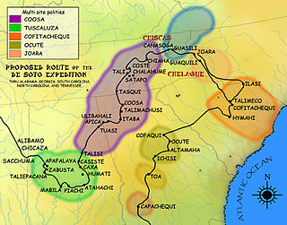
Ocute, later known as Altamaha or La Tama and sometimes known conventionally as the Oconee province, was a Native American paramount chiefdom in the Piedmont region of the U.S. state of Georgia in the 16th and 17th centuries. Centered in the Oconee River valley, the main chiefdom of Ocute held sway over the nearby chiefdoms of Altamaha, Cofaqui, and possibly others.
The Ittiwan people, also spelled Etiwan, were a Native American tribe, who lived near present-day Goose Creek. Sometimes they were referred to as Summerville Indians. They were located approximately 30 miles northeast of Charleston, South Carolina. Members of the Wassamasaw Tribe of Varnertown Indians, a state-recognized tribe in South Carolina claim descent from Ittiwan among other groups.


