
Calca Province is one of thirteen provinces in the Cusco Region in the southern highlands of Peru. Its seat is Calca.

La Convención Province is the largest of thirteen provinces in the Cusco Region in the southern highlands of Peru.

Urubamba Province is one of thirteen provinces in the Cusco Region in the southern highlands of Peru.
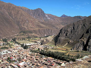
Ollantaytambo District is one of seven districts of the province Urubamba in Peru.
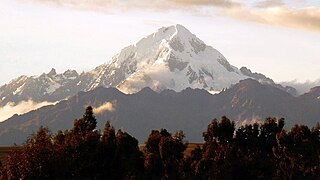
Veronica, also called Huacrahuilki, Huacay Huilcay, Wayna Willka,Waqaywillka, Urubamba, or Padre Eterno, is a 5,893 m (19,334 ft) mountain in the Urubamba mountain range in the Andes of Peru. It is located in the Cusco Region, La Convención Province, Huayopata District, and in the Urubamba Province, Ollantaytambo District northwest of the town of Ollantaytambo.

Huayanay is a mountain and a massif in the Vilcabamba mountain range in the Andes of Peru, about 5,464 metres (17,927 ft) high. The massif is located in the Cusco Region, Anta Province, Huarocondo District and in the Urubamba Province, Ollantaytambo District. Huayanay lies east of Salcantay and Paljay.
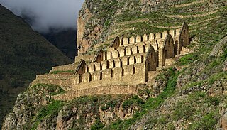
Pinkuylluna or Pinkulluna is an archaeological site on a mountain of the same name in Peru located in the Cusco Region, Urubamba Province, Ollantaytambo District. It is situated between the rivers Patakancha (Patacancha) and Willkanuta, northeast of the town Ollantaytambo.
Yana Urqu or Yana Urku may refer to:

Yanaorjo is a mountain in the Urubamba mountain range in the Andes of Peru, about 4,800 metres (15,748 ft) high. It lies in the Cusco Region, Calca Province, Calca District. Yanaorjo is situated southeast of Sahuasiray, south of Ccerayoc, north of Ajosune or Aqosune and Apurinru and northwest of Pumacallanca and Llamayojcasa.
Yana Urqu is a mountain in the Willkanuta mountain range in the Andes of Peru, about 5,000 metres (16,404 ft) high. It is situated in the Cusco Region, Quispicanchi Province, Marcapata District. Yana Urqu lies southwest of the mountain Q'illu Wallayuq and northeast of Yayamari.
Yana Urqu is a mountain in the north of the Wansu mountain range in the Andes of Peru, about 5,000 m (16,404 ft) high. It is situated in the Apurímac Region, Antabamba Province, Oropesa District. Yana Urqu lies southwest of Willkarana and Kisu Qutu.
Ocobamba is a 5,126-metre-high (16,818 ft) mountain in the Vilcabamba mountain range in the Andes of Peru. It is located in the Cusco Region, Anta Province, Limatambo District, and in the Urubamba Province, Ollantaytambo District. Ocobamba lies southwest of Huayanay.
Salcayoc is a 4,838-metre-high (15,873 ft) mountain in the Urubamba mountain range in the Andes of Peru. It is located in the Cusco Region, Urubamba Province, Ollantaytambo District.
Quellorjo is a mountain in the Urubamba mountain range in the Andes of Peru, about 4,600 m (15,092 ft) high. It is located in the Cusco Region, Urubamba Province, Ollantaytambo District, northwest of Ollantaytambo. It lies southwest of Yurac Orjo.
Yanaorcco is a mountain in the Urubamba mountain range in the Andes of Peru, about 4,800 metres (15,748 ft) high. It lies in the Cusco Region, Calca Province, Lares District. Yanaorcco is situated northwest of Ccerayoc and northeast of Sahuasiray.
Huacratanca is a 5,024-metre-high (16,483 ft) mountain in the Urubamba mountain range in the Andes of Peru. It is located in the Cusco Region, Urubamba Province, Ollantaytambo District. It lies northwest of Salcayoc and Patacancha, and northeast of Huarmaripayoc.
Yana Urqu is a mountain in the Andes of Peru, about 4,800 metres (15,748 ft) high. It is situated in the Cusco Region, Quispicanchi Province, Marcapata District. It lies southwest of Wanakuni and west of a little lake named Q'umirqucha.
Kachi Qhata is a slope in the Cusco Region in Peru with quarries used as a source of porphyry by the Incas. It is located in the Urubamba Province, Ollantaytambo District, about 9 km southwest of Ollantaytambo. It lies near the peak of Yana Urqu.
Llaulliyoc is a mountain north of the Urubamba mountain range in the Andes of Peru, about 4,400 m (14,400 ft) high. It is located in the Cusco Region, La Convención Province, Ocobamba District, and in the Urubamba Province, Ollantaytambo District.


