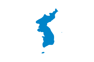
Korea is a region in East Asia. Since 1948, it has been divided between two distinct sovereign states: North Korea and South Korea. Korea consists of the Korean Peninsula, Jeju Island, and several minor islands near the peninsula. Korea is bordered by China to the northwest, Russia to the northeast, and neighbours Japan to the east by the Korea Strait and the Sea of Japan.

The Korean War was a war between North Korea and South Korea. The war began on 25 June 1950 when North Korea invaded South Korea following a series of clashes along the border.

North Korea is located in east Asia on the northern half of the Korean Peninsula.

South Korea is located in East Asia, on the southern half of the Korean Peninsula jutting out from the far east of the Asian landmass. The only country with a land border to South Korea is North Korea, lying to the north with 238 kilometres (148 mi) of border running along the Korean Demilitarized Zone. South Korea is mostly surrounded by water and has 2,413 kilometres (1,499 mi) of coastline along three seas; to the west is the Yellow Sea, to the south is the East China Sea, and to the east is the Sea of Japan. Geographically, South Korea's land mass is approximately 100,032 square kilometres (38,623 sq mi). 290 square kilometres (110 sq mi) of South Korea are occupied by water. The approximate coordinates are 37° North, 127° 30 East.
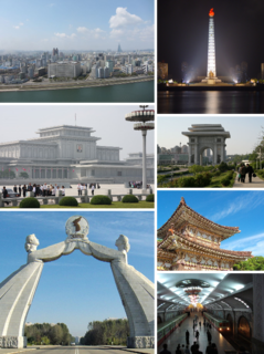
Pyongyang, or P'yŏngyang, is the capital and largest city of North Korea. Pyongyang is located on the Taedong River about 109 kilometres (68 mi) upstream from its mouth on the Yellow Sea. According to the 2008 population census, it has a population of 3,255,288. The city was split from the South Pyongan province in 1946. It is administered as a directly-administered city with equal status to provinces, the same as special cities in South Korea, including Seoul.

The Yalu River, also called the Amrok River or Amnok River, is a river on the border between North Korea and China. Together with the Tumen River to its east, and a small portion of Paektu Mountain, the Yalu forms the border between North Korea and China and is notable as a site involved in military conflicts such as the First Sino-Japanese War, the Russo-Japanese War, World War II, and the Korean War.

The Yellow Sea is located between China and Korea. The name is given to the northern part of the East China Sea, which is a marginal sea of the Pacific Ocean. It is located between mainland China and the Korean Peninsula. Its name comes from the sand particles from Gobi Desert sand storms that turn the surface of the water golden yellow.

Goguryeo, also called Goryeo, was a Korean kingdom located in the northern and central parts of the Korean Peninsula and the southern and central parts of Manchuria. Along with Baekje and Silla, Goguryeo was one of the Three Kingdoms of Korea. It was an active participant in the power struggle for control of the Korean peninsula and was also associated with the foreign affairs of neighboring polities in China and Japan.

The Tumen River, also known as the Tuman or Duman River, is a 521-kilometre (324 mi) long river that serves as part of the boundary between China, North Korea and Russia, rising on the slopes of Mount Paektu and flowing into the East Sea. The river has a drainage basin of 33,800 km2.

Yanbian is an autonomous prefecture in northeastern Jilin Province, China. Yanbian is bordered to the north by Heilongjiang, on the west by Baishan and Jilin City, on the south by North Hamgyong Province of North Korea, and on the east by Primorsky Krai of Russia. Yanbian is designated as the Korean autonomous prefecture due to the large number of ethnic Koreans living in the region. The prefectural capital is Yanji, and the total area is 42,700 square kilometres (16,500 sq mi).

The Korean Peninsula is located in East Asia. It extends southwards for about 1,100 km (680 mi) from continental Asia into the Pacific Ocean and is surrounded by the Sea of Japan to the east and the Yellow Sea to the west, the Korea Strait connecting the two bodies of water.

Gyeonggi-do is the most populous province in South Korea. Its name, Gyeonggi means "the area surrounding the capital". Thus Gyeonggi-do can be translated as "province surrounding Seoul". The provincial capital is Suwon. Seoul—South Korea's largest city and national capital—is in the heart of the province but has been separately administered as a provincial-level special city since 1946. Incheon—South Korea's third-largest city—is on the coast of the province and has been similarly administered as a provincial-level metropolitan city since 1981. The three jurisdictions are collectively referred to as Sudogwon and cover 11,730 km2 (4,530 sq mi), with a combined population of 25.5 million—amounting to over half of the entire population of South Korea.

Ulsan, officially the Ulsan Metropolitan City, is South Korea's seventh-largest metropolitan city and the eight-largest overall with a population of over 1.1 million inhabitants. It is located in the south-east of the country, neighboring Busan to the south and facing Gyeongju to the north.

Chuncheon is the capital of Gangwon Province in South Korea. The city lies in the north of the county, located in a basin formed by the Soyang River and Han River. There are some large lakes around the city, most notably Lake Soyang and Lake Uiam. The area is renowned for its small river islands, such as Sangjungdo, Ha-Jungdo, Bungeodo and Wido.

The Taedong River is a large river in the North Korea. It rises in the Rangrim Mountains of the country's north. It then flows southwest into Korea Bay at Namp'o. In between, it runs through the country's capital, Pyongyang. Along the river are landmarks such as the Juche Tower and Kim Il-sung Square.

The Nakdong River or Nakdonggang is the longest river in South Korea, and passes through major cities such as Daegu and Busan. It takes its name from its role as the eastern border of the Gaya confederacy during Korea's Three Kingdoms Era.

Yeouido is a large island on the Han River in Seoul, South Korea. It is Seoul's main finance and investment banking district. Its 8.4 square kilometers are home to some 30,988 people. The island is located in the Yeongdeungpo-gu district of Seoul, and largely corresponds to the precinct of Yeouido-dong. The island contains the National Assembly Building, where the National Assembly of South Korea meets, Korea Financial Investment Association, the large Yoido Full Gospel Church, the 63 Building, and the headquarters of LG, Korean Broadcasting System, and the Korea Exchange Center. Due mainly to its importance as a financial district and its central location, Yeouido is home to some of Seoul and South Korea's tallest skyscrapers, including International Finance Center Seoul, the Federation of Korea Industries Tower, as well as the iconic 63 Building.

Seoul, officially the Seoul Special City, is the capital and largest metropolis of South Korea. With surrounding Incheon metropolis and Gyeonggi province, Seoul forms the heart of the Seoul Capital Area, home to roughly half of the country's population. Seoul is ranked as the fourth largest metropolitan economy in the world and is larger than London and Paris.

