East Turkestan, also East Turkistan, varies in meaning by context and usage. The term was coined in the 19th century by Russian Turkologists including Nikita Bichurin to replace another Western term, Chinese Turkestan, which referred to the Tarim Basin in the southwestern part of Xinjiang during the Qing Dynasty. The medieval Persian toponym "Turkestan" and its derivatives were not, however, used by the local population. The Uyghur name for the Tarim Basin is Altishahr, which means "Six Cities" in Uyghur. Besides, China had since the Han Dynasty had its own name for an overlapping area: the "Western Regions." The parts of this area controlled by China were termed "Xinjiang" starting in the 18th century.

The Dzungar Khanate, also written as the Zunghar Khanate, was an Inner Asian khanate of Oirat Mongol origin. At its greatest extent, it covered an area from southern Siberia in the north to present-day Kyrgyzstan in the south, and from the Great Wall of China in the east to present-day Kazakhstan in the west. The core of the Dzungar Khanate is today part of northern Xinjiang, also called Dzungaria.

Yarkant County, also Shache County, also transliterated from Uyghur as Yakan County, is a county in the Xinjiang Uyghur Autonomous Region, China, located on the southern rim of the Taklamakan Desert in the Tarim Basin. It is one of 11 counties administered under Kashgar Prefecture. The county, usually referred to as Yarkand in English, was the seat of an ancient Buddhist kingdom on the southern branch of the Silk Road and the Yarkand Khanate. The county sits at an altitude of 1,189 metres (3,901 ft) and as of 2003 had a population of 373,492.
There are various kinds of Xinjiang coins produced throughout the history of Xinjiang using the styles of contemporary Chinese cash coins as well as Persian and Islamic coinages. As not many records exist from the ancient monarchies of Xinjiang the study of its coinage has determined when which rules reigned and the state of the economy based on metallurgical analyses.

The Yarkand River is a river in the Xinjiang Uyghur Autonomous Region of western China. It originates in the Rimo Glacier in a part of the Karakoram range and disputed between India, China and Pakistan, and flows into the Tarim River or Neinejoung River, with which it is sometimes identified. However, in modern times, the Yarkand river drains into the Shangyou Reservoir and exhausts its supply without reaching the Tarim river. The Yarkand River is approximately 1,332.25 km (827.82 mi) in length, with an average discharge of 210 m3/s (7,400 cu ft/s).

Xinjiang historically consisted of two main geographically, historically, and ethnically distinct regions with different historical names: Dzungaria north of the Tianshan Mountains; and the Tarim Basin south of the Tianshan Mountains, currently mainly inhabited by the Uyghurs. They were renamed Xinjiang (新疆) in 1884, meaning "new frontier," when both regions were reconquered by the Chinese Qing dynasty after the Dungan revolt (1862–1877).

Afaq Khoja, also known as Apaq Xoja or more properly Āfāq Khwāja, was a religious and political leader with the title of Khwaja in Kashgaria. He was also known as Khwāja Hidāyat Allāh.

Makit County is a county in Kashgar Prefecture, Xinjiang Uyghur Autonomous Region, China. It contains an area of 10,927 km2 (4,219 sq mi). The Yarkand River passes through the county. The county is bordered to the north by Maralbexi County, to the east by Guma County (Pishan) in Hotan Prefecture, to the west by Yarkant County, and to the south by Kargilik County.

Akto County is a county in Kizilsu Kyrgyz Autonomous Prefecture, Xinjiang Uygur Autonomous Region, China. The county borders Tajikistan and Kyrgyzstan and has two towns, 11 townships, four state-owned farms and a plant nursery under its jurisdiction with the county seat is Akto Town. The county contains an area of 24,555 km2 (9,481 sq mi) and has a population of 231,756.

Moghulistan, also called the Eastern Chagatai Khanate, was a Mongol breakaway khanate of the Chagatai Khanate and a historical geographic area north of the Tengri Tagh mountain range, on the border of Central Asia and East Asia. That area today includes parts of Kazakhstan, Kyrgyzstan, and northwest Xinjiang, China. The khanate nominally ruled over the area from the mid-14th century until the late 17th century, although it is debated whether it was a continuation of the Chagatai Khanate, an independent khanate, or a tributary state to Ming Dynasty China.
Abdurashid Khan was the ruler of the Yarkent Khanate in modern-day Yarkant County, Xinjiang between 1533 and 1560.

Āmānnisā Khan Nāfisi, also known as Amanni Shahan, was a concubine of Abdurashid Khan of the Yarkent Khanate. She is credited with collecting and thereby preserving the Twelve Muqam, which is today considered a musical style of the Uyghur people of Northwest China. The Muqam of Xinjiang has been designated by UNESCO as part of the Intangible Heritage of Humanity.
Xinjiang is an area located in Central Asia, between 73 ° 5 'to 96 ° 4' east and 35 ° 5 'and 49 ° north, in total 1,660,000 square Km, share border with Mongolia, Russia, Kazakhstan, Kyrgyzstan, Tajikistan, Afghanistan, India, Pakistan and China's Tibet Autonomous Region, Qinghai province and Gansu province. This region had been called Western Regions in China's history and is currently known as the China's Xinjiang Uyghur Autonomous Region in provincial-level.

The Tashkurgan River is a river in the Xinjiang Uyghur Autonomous Region of western China. The Tashkurgan River runs through Tashkurgan Tajik Autonomous County and is one of the tributaries of the Yarkand River in the Tarim Basin.

Xinjiang, officially Xinjiang Uyghur Autonomous Region (XUAR), is an autonomous region of the People's Republic of China (PRC), located in the northwest of the country close to Central Asia. Being the largest province-level division of China and the 8th-largest country subdivision in the world, Xinjiang spans over 1.6 million km2 and has about 25 million inhabitants.
The Karatash River, is south of Kashgar in the Kongur Tagh Range,, of the Xinjiang Uyghur Autonomous Region of China. It runs from near the eastern side of the 'Old Karatash Pass' (which is about 30 km southeast of Karakul lake, to the east and then northerly through the small Khirghiz villages of Shargut, Chat, Chimgan and Khan-Terek, flowing out into the Taklamakan Desert about halfway between Kashgar and Yangi Hissar.
"In a sense, the Karatash was very well-known historically, but only in its upper reaches. These lie on what seems to have been a standard trade route from Yarkand to Lake Karakul and beyond."
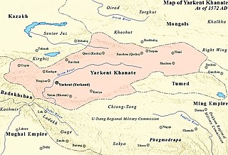
The Yarkent Khanate, also known as the Yarkand Khanate and the Kashghar Khanate, was a state ruled by the Mongol descendants of Chagatai Khan, the majority of whose subjects and conquered population was Turkic in Central Asia. It was founded by Sultan Said Khan in 1514 as a western offshoot of Moghulistan, itself an eastern offshoot of the Chagatai Khanate. It was eventually conquered by the Dzungar Khanate in 1705.
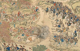
The Revolt of the Altishahr Khojas was an uprising against the Qing dynasty of China, which broke out in 1757 during the reign of the Qianlong Emperor. The rebels were led by Khwāja-i Jahān, leader of the White Mountain Sufis. Qing era documents refer to the event as the "Pacification of the Muslim regions". Hojijan and his brother, Burhān al-Dīn, both held the Muslim title Khoja.
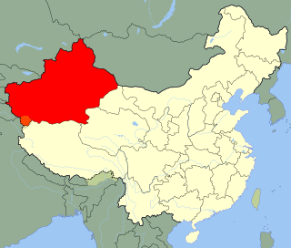
Altishahr is a historical name for the Tarim Basin region used in the 18th and 19th centuries. The term means the "six cities" in Turkic languages and refers to oasis towns along the rim of the Tarim, in what is now southern Xinjiang Uyghur Autonomous Region of China. Six cities (Altishahr) was synonymous with Kashgaria.

"Red cash coins" are the cash coins produced in Xinjiang under Qing rule following the conquest of the Dzungar Khanate by the Manchus in 1757. While in Northern Xinjiang the monetary system of China proper, with standard cash coins, was adopted in Southern Xinjiang where the pūl (ﭘول) coins of Dzungaria circulated earlier the pūl-system was continued but some of the old Dzungar pūl coins were melted down to make Qianlong Tongbao (乾隆通寶) cash coins, as pūl coins were usually around 98% copper they tended to be very red in colour which gave the cash coins based on the pūl coins the nickname "red cash coins".