Ethiopia, Oromo: Itiyoophiyaa, Somali: Itoobiya, Hebrew: אתיופיה -officially the Federal Democratic Republic of Ethiopia, is a country in the northeastern part of Africa, popularly known as the Horn of Africa. It shares borders with Eritrea to the north, Djibouti to the northeast, and Somalia to the east, Sudan and South Sudan to the west, and Kenya to the south. With over 102 million inhabitants, Ethiopia is the most populous landlocked country in the world and the second-most populous nation on the African continent that covers a total area of 1,100,000 square kilometres (420,000 sq mi). Its capital and largest city is Addis Ababa, which lies a few miles west of the East African Rift that splits the country into the Nubian Plate and the Somali Plate.
State of Tigray is the northernmost of the nine regions (kililat) of Ethiopia. Tigray is the homeland of the Tigrayan, Irob and Kunama peoples. Tigray is also known as Region 1 according to the federal constitution. Its capital and largest city is Mekelle. Tigray is the 6th largest by area, the 5th most populous, and the 5th most densely populated of the 9 Regional States.
Records provided at the Nordic Africa Institute website mention a rock-hewn church dedicated to Abuna Aregawi in the town.[1] The British explorer Henry Salt camped overnight outside this town during his second journey through Ethiopia in 1809. Salt (who calls the settlement "Shela") records entering the province of Abergele the next day -- apparently the town was not part of the province at the time -- as well as finding a species of water cress growing in the area.[2]
Abuna Aregawi was a sixth-century monk, whom tradition holds founded the monastery Debre Damo in Tigray, said to have been commissioned by Emperor Gebre Mesqel of Axum.
Henry Salt was an English artist, traveller, collector of antiquities, diplomat, and Egyptologist.
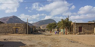
Based on figures from the Central Statistical Agency in 2005, Yechila has an estimated total population of 2,833 of whom 1,371 are men and 1,462 are women.[3] The 1994 census reported it had a total population of 1,556 of whom 697 were men and 859 were women.
This page is based on this Wikipedia article Text is available under the CC BY-SA 4.0 license; additional terms may apply. Images, videos and audio are available under their respective licenses.
Related Research Articles
Goba is a town and separate woreda in south-central Ethiopia. Located in the Bale Zone of the Oromia Region approximately 446 km southeast of Addis Ababa, this city has a latitude and longitude of 7°0′N39°59′E and an elevation of 2,743 meters above sea level.
Edaga Hamus is a town in northern Ethiopia. Located 97 kilometers north of Mekele in the Misraqawi Zone of the Tigray Region of Ethiopia, this town has a latitude and longitude of 14°11′N39°34′E with an elevation of 2670 meters above sea level.
Idaga Hamus is located on "National Road 1", between Freweyni and Adigrat.
Bolo is a town in central Ethiopia. Located in the Arsi Zone of the Oromia Region, it has a latitude and longitude of 8°50′N39°22′E with an elevation of 1891 meters above sea level.
Sendafa is a town and separate woreda in central Ethiopia. Its name is taken from the Oromo name for a kind of thick, jointed grass or reed which grows in swampy areas. Located in the Oromia Special Zone Surrounding Finfinne of the Oromia Region, Sendafa has a latitude and longitude of 9°09′N39°02′E with an elevation of 2514 meters above sea level. The town lies on the paved Addis Ababa - Adigrat highway, some 38 kilometers north of the capital.
Enticho is a town in northern Ethiopia. Located on the Inguya River in the Mehakelegnaw (Central) Zone of the Tigray Region, it has a latitude and longitude of 14°16′N39°09′E with an elevation of 1964 meters above sea level. It is the administrative center of Enticho woreda.
Wenji Gefersa is a town in central Ethiopia. Located in the Misraq (East) Shewa Zone of the Oromia Region, it has a latitude and longitude of 8°27′N39°17′E with an elevation of 1588 meters above sea level.
Robe, more commonly known as Bale Robe, is a town and separate woreda in south-central Ethiopia. Located in the Bale Zone of the Oromia Region, this town has a latitude and longitude of 7°7′N40°0′E with an elevation of 2,492 metres (8,176 ft) above sea level.
Shewa Robit is a town in north-central Ethiopia. Located in the Semien Shewa Zone of the Amhara Region, this town has a longitude and latitude of 10°00′N39°54′E with an elevation of 1280 meters above sea level. Shewa Robit holds its market on Wednesdays.
Asasa is a town in southeastern Ethiopia. Located in the Mirab Arsi Zone of the Oromia Region, this town has a latitude and longitude of 07°06′N39°12′E with an elevation of 2367 meters above sea level. It is the administrative center of Gedeb Asasa woreda.
Alem Gena is a town in central Ethiopia. Located in the Mirab Shewa Zone of the Oromia Region, it has a longitude and latitude of 8°55′N38°39′E with an elevation of 2369 meters above sea level. Alem Gena is one of four towns in Alem Gena woreda.
Gidole is a town in southern Ethiopia, and is the administrative center of the Dirashe special woreda. Located in the Southern Nations, Nationalities, and Peoples Region, it sits at a latitude and longitude of 05°39′N37°22′E with an elevation ranging from 2045 to 2650 meters above sea level. The town is named after the Gidole or Gardulla people, an ethnic group inhabiting southern Ethiopia better known as the Dirashe.
Atsbi is a town in Tigray, Ethiopia. Located in the Misraqawi (Eastern) Zone of the Tigray Region, about 50 kilometers northeast of Qwiha, this town has a latitude and longitude of 13°52′N39°44′E with an elevation of 2630 meters above sea level. It is the administrative center of Atsbi Wenberta woreda.
Abala is a town in north-eastern Ethiopia. The administrative center of Zone 2 of the Afar Region, this town has a latitude and longitude of 13°22′N39°45′E with an elevation of 1482 meters above sea level.
Dibina is a town in north-eastern Ethiopia, located in Administrative Zone 4 of the Afar Region. This may be the "Debene" W.C. Harris mentions, a small village he passed through in mid-June 1841 on his diplomatic mission to Shewa.
Dera is a town in southeastern Ethiopia. Located in the Arsi Zone of the Oromia Region, this town has a latitude and longitude of 08°20′N39°19′E. It is the administrative center of Dodotana Sire woreda.
Iteya is a town in southeastern Ethiopia. Located in the Arsi Zone of the Oromia Region east of Lake Zway, it has a latitude and longitude of 08°08′N39°14′E with an elevation of 2215 meters above sea level. It is the administrative center of the Hitosa woreda.
Waja is a town in northern Ethiopia. Located in the south of the city of Alamata, bordered by tigray region in the north; by raya kobo in south. this town has a latitude and longitude of 12°17′N39°36′E with an elevation of 1471 meters above sea level.
Tijo is a town in central Ethiopia. Located in the Arsi Zone of the Oromia Region about 25 kilometers east of Sagure, it has a latitude and longitude of 7°47′N39°9′E with an elevation of 2,405 meters. It is one of three settlements in Digeluna Tijo woreda.
Gonde is a town in central Ethiopia. Located in the Arsi Zone of the Oromia Region to the south of Asella, on the river of the same name, the town has a latitude and longitude of 8°03′N39°18′E with an elevation of 2,295 meters.
Agula is a town located in northern Ethiopia. Located in the Debubawi (Southern) Zone of the Tigray Region, it lies about 32 km northeast of Mek'ele, just east of the Mek'ele - Addis Ababa highway, and 25 km north of Qwiha. It has a latitude and longitude of 13°41′30″N39°35′30″E with an elevation of 1930 metres above sea level. Nearby is a stream and a pass which share the same name.