The Federated States of Micronesia, or simply Micronesia, is an island country in Micronesia, a subregion of Oceania. It consists of four states—from west to east, Yap, Chuuk, Pohnpei and Kosrae—that are spread across the western Pacific. Together, the states comprise around 607 islands that cover a longitudinal distance of almost 2,700 km (1,700 mi) just north of the equator. They lie northeast of Indonesia and Papua New Guinea, south of Guam and the Marianas, west of Nauru and the Marshall Islands, east of Palau and the Philippines, about 2,900 km (1,800 mi) north of eastern Australia, 3,400 km (2,100 mi) southeast of Japan, and some 4,000 km (2,485 mi) southwest of the main islands of the Hawaiian Islands.

Geography of the Federated States of Micronesia (FSM), a country located in the western Pacific Ocean, and in the Micronesia cultural and ecological sub-region of Oceania. While its total land area is very small at 702 km2 (271 sq mi), it has the 14th largest exclusive economic zone at 2,996,419 km2 (1,156,924 sq mi).

Kosrae, formerly known as Kusaie or Strong's Island, is an island in the Federated States of Micronesia. The State of Kosrae is one of the four states of the Federated States of Micronesia, and includes the main island of Kosrae and a few nearby islands and islets, the most significant of which is inhabited by 1,500 people.
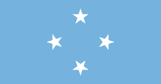
The flag of the Federated States of Micronesia was adopted on 30 November 1978. The blue field represents the Pacific Ocean. In an echo of U.S. heraldic practice, the stars represent the four federated states: Chuuk, Pohnpei, Kosrae and Yap, arranged like the points of the compass.

Tafunsak is the largest settlement on the island of Kosrae in the Federated States of Micronesia. Its population was 2,457 at the 2000 census. This includes Walung, which had been incorporated into the municipality of Tafunsak since the 1980s. The area of the municipality is 42.8 km2, making it the largest municipality by area. This includes the 19.5 km2 of former Walung municipality.

Kosraean is the language spoken on the islands of Kosrae (Kusaie), a nation-state of the Federated States of Micronesia, Caroline Islands. In 2001 there were approximately 8,000 speakers in Micronesia, and 9,060 in all countries.

Kosrae International Airport is an airport serving Kosrae, the easternmost state of the Federated States of Micronesia. It is located on an artificial island within the fringing reef about 150 meters from the coast and is connected to the main island by a causeway.

The College of Micronesia-FSM (COM-FSM) is a public community college in the Federated States of Micronesia. It began operation in 1963 as the Micronesian Teacher Education Center.
Walung was the smallest of the original five municipalities of the state of Kosrae, Federated States of Micronesia. Since the 1980s, it has been part of the municipality of Tafunsak.
Utwa Ma is the capital of Utwa, a municipality in the Micronesian state of Kosrae.
The following outline is provided as an overview of and topical guide to Micronesia:
Christianity is the predominant religion in the Federated States of Micronesia and represents an integral part of the nation's identity.

Alik L. Alik is a diplomat and politician from the Federated States of Micronesia who was the Vice President of the Federated States of Micronesia from May 11, 2007 to May 11, 2015.
Mount Finkol includes the highest point on the island of Kosrae in the Federated States of Micronesia. It rises to a height of 2064 ft.

The office of the Governor of Kosrae is the highest position in the state of Kosrae, Federated States of Micronesia.
Terminalia carolinensis, commonly known as the ka tree or keima tree, is a tree that grows on the Micronesian islands of Kosrae and Pohnpei. The trees have umbrella shaped crowns and mossy buttressed bases. The trees are found in the Yela Forest. Known as Keima on Pohnpei and Ka on Kosrae, it is used for timber, canoe manufacture, cabinetry, flooring, for medicine and for its edible nuts.
Kosrae High School (KHS) is a secondary school in Tofol, Lelu municipality, Kosrae State, Federated States of Micronesia. It is a part of the Kosrae State Department of Education and is the island's sole high school.

The Carolines tropical moist forests is a tropical and subtropical moist broadleaf forests ecoregion in Micronesia. It includes the central and eastern Caroline Islands in the Federated States of Micronesia.

Federated States of Micronesia National Olympic Committee is the National Olympic Committee representing Federated States of Micronesia.
