Yellow River (Wisconsin River tributary)

Last updated
The upper Yellow in April after spring floods, at County N in Wood County. Yellow River Wisconsin.jpg
The upper Yellow in April after spring floods, at County N in Wood County.

The Yellow River is a tributary of the Wisconsin River in Clark, Wood and Juneau counties in Wisconsin, in the United States. [1]

Contents

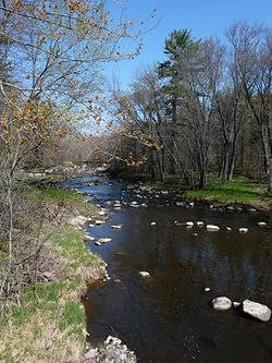
The Yellow River originates in eastern Clark County. It flows south through Pittsville, Dexter and Babcock in Wood County, and Necedah in Juneau County. Past Necedah, it flows into Castle Rock Lake where it meets the Wisconsin River near Buckhorn State Park. In Dexterville it is dammed to create Lake Dexter. The stretch from Necedah to Castle Rock Lake has numerous oxbows. [2]

In the Menominee language, the river is known as Mēkon-Sēpēw, "plume or feather river". [3]

Tributaries

Tributaries of the Yellow River include:

Related Research Articles

Wood County, Wisconsin County in Wisconsin, United States

Wood County is a county located in the U.S. state of Wisconsin. As of the 2010 census, the population was 74,749. Its county seat is Wisconsin Rapids. The county is named after Joseph Wood, a member of the Wisconsin State Assembly. Wood County comprises the Wisconsin Rapids-Marshfield, WI Micropolitan Statistical Area and is included in the Wausau-Stevens Point-Wisconsin Rapids, WI Combined Statistical Area.

Fox River (Green Bay tributary) River in Wisconsin, United States

The Fox River is a river in eastern Wisconsin in the Great Lakes region of the United States. It is the principal tributary of the Bay of Green Bay, and via the Bay, the largest tributary of Lake Michigan. The well-known city of Green Bay, one of the first European settlements in North America, is on the river at its mouth on lower Green Bay.

Rock River (Mississippi River tributary) Tributary of the Mississippi River in the US

The Rock River is a tributary of the Mississippi River, approximately 299 miles (481 km) long, in the U.S. states of Wisconsin and Illinois. The river was known as the Sinnissippi to Sauk and Fox Indians; the name means "rocky waters".

Menominee River River in Wisconsin and Michigan

The Menominee River is a river in northwestern Michigan and northeastern Wisconsin in the United States. It is approximately 116 miles (187 km) long, draining a rural forested area of northern Wisconsin and the Upper Peninsula of Michigan into Lake Michigan. Its entire course, with that of its tributary, the Brule River, forms part of the boundary between the two states.

The Menomonee River is one of three primary rivers in Milwaukee, Wisconsin, along with the Kinnickinnic River and Milwaukee River.

Baraboo River River in Wisconsin, United States

The Baraboo River is a tributary of the Wisconsin River, about 70 mi (115 km) long, in south-central Wisconsin in the United States. Via the Wisconsin River, it is part of the watershed of the Mississippi River.

Bark River (Rock River tributary)

The Bark River is a tributary of the Rock River, about 67.5 miles (108.6 km) long, in southeastern Wisconsin in the United States. Via the Rock River, it is part of the watershed of the Mississippi River. According to the Geographic Names Information System, it has also been known historically as the "Peelbark River". The Bark River rises in southern Washington County at Bark Lake In Richfield, WI and flows generally southwestwardly through Waukesha and Jefferson counties, past the communities of Hartland, Delafield, Summit Dousman and Rome, and through several small lakes. It joins the Rock River in Jefferson County just east of Fort Atkinson. In Jefferson County the Bark River collects the Scuppernong River.

Black River (Wisconsin)

The Black River is a river in west-central Wisconsin and tributary of the Mississippi River. The river is approximately 190 miles (310 km) long. During the 19th century, pine logs were rafted down the Black, heading for sawmills at La Crosse and points beyond.

Menominee River (Illinois)

The Menominee River is an 11.3-mile-long (18.2 km) tributary of the Mississippi River, which it joins in Jo Daviess County, Illinois.

The Little Eau Pleine River is a river in the U.S. state of Wisconsin.

The Lemonweir River is a river in the U.S. state of Wisconsin.

Tomahawk River

The Tomahawk River is a river in the U.S. state of Wisconsin.

The Big Eau Pleine River is a river in the U.S. state of Wisconsin. It is a tributary of the Wisconsin River as the Big Eau Pleine River originates in southern Taylor County near Stetsonville and flows into Marathon County. The Big Eau Pleine River flows by Stratford then to the large Big Eau Pleine Reservoir before it converges into the Wisconsin River at Lake DuBay. The Little Eau Pleine River, which flows from Clark County through Marathon County and into Portage County, is not a tributary of the Big Eau Pleine.

Cutler is an unincorporated community located in the Town of Cutler, Juneau County, Wisconsin, United States.

Sprague is an unincorporated community located in the town of Necedah, Juneau County, Wisconsin, United States. Sprague is located on Wisconsin Highway 80 and the Canadian National Railway 8.5 miles (13.7 km) north-northwest of the village of Necedah. The community is likely named for John and Gleason Sprague, the owners and publishers of the Mauston Star newspaper in the late 19th century. The post office was established in February 1907 with Michael Anthony as postmaster.

Regions of Wisconsin

There are a variety of schema for dividing Wisconsin into regions.

Beaver Creek is a stream in the U.S. state of Wisconsin. It is a tributary to the Yellow River.

Owl Creek is a stream in Wood County in the U.S. state of Wisconsin. It is a tributary of the Yellow River within Lake Dexter.

References

  1. U.S. Geological Survey Geographic Names Information System: Yellow River (Wisconsin River tributary)
  2. Necedah, WI (1969) and Kelly, WI (1983), 7.5 Minute Topographic Quadrangles, USGS
  3. Hoffman, Mike. "Menominee Place Names in Wisconsin". The Menominee Clans Story. Retrieved 2018-10-05.
  4. U.S. Geological Survey Geographic Names Information System: Yellow River (Wisconsin River tributary)

See also

Coordinates: 43°54′23″N89°58′59″W / 43.90639°N 89.98306°W / 43.90639; -89.98306