
Duchesne County is a county located in the U.S. state of Utah. As of the 2010 census, the population was 18,607. Its county seat is Duchesne, and the largest city is Roosevelt.

Uintah County is a county located in the U.S. state of Utah. As of the 2010 census the population was 32,588. Its county seat and largest city is Vernal. The county was named for the portion of the Ute Indian tribe that lived in the basin.

Wayne County is a county located in the U.S. state of Utah. As of the 2010 census, the population was 2,778, making it the fourth-least populous county in Utah. Its county seat is Loa. The county was formed from Piute County in 1892, and gets its name from Wayne County, Tennessee.

The San Rafael River is a tributary of the Green River, approximately 90 miles (140 km) long, in east central Utah in the United States. The river flows across a sparsely populated arid region of the Colorado Plateau, and is known for the isolated, scenic gorge through which it flows.

The Escalante River is a tributary of the Colorado River. It is formed by the confluence of Upper Valley and Birch Creeks near the town of Escalante in south-central Utah, and from there flows southeast for approximately 90 miles (140 km) before joining Lake Powell. Its watershed includes the high forested slopes of the Aquarius Plateau, the east slope of the Kaiparowits Plateau and the high desert north of Lake Powell. It was the last river of its size to be discovered in the 48 contiguous U.S. states. The average discharge is approximately 146 cfs.
The Roan Cliffs are a series of desert mountains and cliffs in eastern Utah and western Colorado, in the western United States that are distinct from the Book Cliffs.

The Price River is a river in eastern Utah, United States.

Sonoita Creek is a stream in Santa Cruz County, Arizona. It originates near and takes its name from the abandoned Pima mission in the high valley near Sonoita. It flows steadily for the first 15 miles (24 km) of its westward course past Patagonia, its bird sanctuary and Patagonia Lake, but sinks beneath the sand seven to eight miles (13 km) before joining the Santa Cruz River a few miles north of Nogales. This confluence provides water for Tumacácori and Tubac and collects in the marsh lands around San Xavier del Bac downstream, to the north. The Santa Rita Mountains lie to the north and the Canelo Hills, Red Mountain and the Patagonia Mountains lie to the south. Harshaw Creek is a southern tributary which joins the Sonoita near Patagonia. Harshaw Creek drains the area between the Patagonia Mountains to the west and the high San Rafael Valley grasslands to the east. The ghost town of Harshaw lies within its watershed. Sonoita Creek contains black bullhead, red shiner, mosquitofish, crayfish, American bullfrogs, largemouth bass, Gila topminnows, speckled dace, longfin dace, Sonora suckers, and desert suckers.

Muddy Creek is a stream in central Utah, United States, that drains portions of Emery, Sanpete, Sevier, and Wayne counties.

The Book Cliffs are a series of desert mountains and cliffs in western Colorado and eastern Utah, in the western United States. They are so named because the cliffs of Cretaceous sandstone that cap many of the south-facing buttes appear similar to a shelf of books.

The Canyons of the Escalante is a collective name for the erosional landforms created by the Escalante River and its tributaries—the Escalante River Basin. Located in southern Utah in the western United States, these sandstone features include high vertical canyon walls, numerous slot canyons, waterpockets, domes, hoodoos, natural arches and bridges. This area—extending over 1,500 square miles (3,885 km2) and rising in elevation from 3,600 ft (1,097 m) to over 11,000 ft (3,353 m)—is one of the three main sections of the Grand Staircase-Escalante National Monument, and also a part of the Glen Canyon National Recreation Area, with Capitol Reef National Park being adjacent to the east.

The Kettle River Range, often called the Kettle Range, is the southernmost range of the Monashee Mountains, located in far southeastern British Columbia, Canada and Ferry County, Washington, in the United States. Most of the northern half of the range is protected by the Colville National Forest and the southern half of the range is located on the Colville Indian Reservation. The highest peak is Copper Butte, which reaches 2,177 metres (7,142 ft). The range is crossed by Washington State Route 20 at Sherman Pass.

The Historic Union Pacific Rail Trail State Park is a recreational trail that follows abandoned railroad lines in Summit County, Utah, United States.
The Strawberry River is an 18-mile (29 km) river located in eastern Utah, United States.
Box Elder Canyon is a canyon located within the western slopes of the Wellsville Mountains, a branch of the Wasatch Range of the Rocky Mountains in Utah, United States.
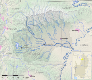
The Lake Fork River is a river in Duchesne County, Utah in the United States. It flows for 54 miles (87 km) from the Uinta Mountains, in a southeasterly direction, receiving the Yellowstone River above Mountain Home, to join the Duchesne River near Myton. The river is dammed near its headwaters to form Moon Lake, formerly a smaller natural lake.
Henrys Fork is a 61-mile (98 km) long tributary of the Green River in Utah and Wyoming. Originating in the Uinta Mountains of Utah, the river flows north into Wyoming, where it turns east, passing Lonetree, Burntfork, and McKinnon. Near Manila, Utah the river loops back south into Utah, emptying into the Flaming Gorge Reservoir where it joins the Green River.
The Uinta River is a tributary of the Duchesne River flowing through Duchesne and Uintah County, Utah. Originating in the Uinta Mountains, the river flows southeast for about 60 miles (97 km) to join the Duchesne near Randlett. The Uinta is an important source of water for local irrigation. Its tributaries include the Whiterocks River, which joins it near Whiterocks, and the Dry Gulch Creek near Fort Duchesne.
The Whiterocks River is a river in Uintah County, Utah in the United States. It flows south for about 29 miles (47 km) from the Uinta Mountains to join the Uinta River, a tributary of the Duchesne River, near Whiterocks.


