Detroit Lake is a reservoir impounded by the Detroit Dam on the North Santiam River 46 miles (74 km) southeast of Salem, Oregon, United States. The lake is adjacent to Oregon Route 22 near the city of Detroit. This mesotrophic lake stores water for use by the city of Salem and other nearby communities.

Lake Mead is a reservoir formed by Hoover Dam on the Colorado River in the Southwestern United States. It is located in the states of Nevada and Arizona, 24 mi (39 km) east of Las Vegas. It is the largest reservoir in the US in terms of water capacity. Lake Mead provides water to the states of Arizona, California, and Nevada as well as some of Mexico, providing sustenance to nearly 20 million people and large areas of farmland.
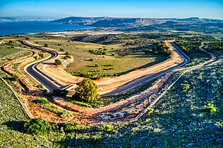
The National Water Carrier of Israel is the largest water project in Israel, completed in 1964. Its main purpose is to transfer water from the Sea of Galilee in the north of the country to the highly populated center and the arid south and to enable efficient use of water and regulation of the water supply in the country. It is about 130 kilometers (81 mi) long. Up to 72,000 cubic meters of water can flow through the carrier each hour, totalling 1.7 million cubic meters in a day.

Toledo Bend Reservoir is a reservoir on the Sabine River between Texas and Louisiana. The lake has an area of 185,000 acres (750 km2), the largest man-made body of water partially in both Louisiana and Texas, the largest in the South, and the fifth largest by surface acre in the United States. The dam is capable of generating 92 megawatts of electrical power. The dam itself is located in the northeast corner of Newton County, Texas; however, that county includes very little of the reservoir, as most of it extends northward into parts of Sabine and DeSoto parishes in Louisiana, and Sabine, Shelby, and Panola counties in Texas.

Yeruham is a town in the Southern District of Israel, in the Negev desert. It covers 38,584 dunams, and had a population of 11,031 in 2021. It is named after the Biblical Jeroham.
Steelhead, or occasionally steelhead trout, is the common name of the anadromous form of the coastal rainbow trout (Oncorhynchus mykiss irideus) or Columbia River redband trout. Steelhead are native to cold-water tributaries of the Pacific basin in Northeast Asia and North America. Like other sea-run (anadromous) trout and salmon, steelhead spawn in freshwater, smolts migrate to the ocean to forage for several years and adults return to their natal streams to spawn. Steelhead are iteroparous, although survival is approximately 10–20%.

Lake Oroville is a reservoir formed by the Oroville Dam impounding the Feather River, located in Butte County, northern California. The lake is situated 5 miles (8 km) northeast of the city of Oroville, within the Lake Oroville State Recreation Area, in the western foothills of the Sierra Nevada. Known as the second-largest reservoir in California, Lake Oroville is treated as a keystone facility within the California State Water Project by storing water, providing flood control, recreation, freshwater releases to assist in controlling the salinity intrusion into the Sacramento-San Joaquin Delta and protecting fish and wildlife.

Lake Allatoona is a U.S. Army Corps of Engineers reservoir on the Etowah River in northwestern part of the State of Georgia. This reservoir is mostly in southeastern Bartow County and southwestern Cherokee County. A small portion is located in Cobb County near Acworth.

Table Rock Lake is an artificial lake or reservoir in the Ozarks of southwestern Missouri and northwestern Arkansas in the United States. Designed, built and operated by the U.S. Army Corps of Engineers, the lake is impounded by Table Rock Dam, which was constructed from 1954 to 1958 on the White River.

Jennings Randolph Lake is a reservoir of 952 acres (3.85 km2) located on the North Branch Potomac River in Garrett County, Maryland and Mineral County, West Virginia. It is approximately 8 miles (13 km) upstream of Bloomington, Maryland, and approximately 5 miles (8.0 km) north of Elk Garden, West Virginia.

The Somerset Dam is a mass concrete gravity dam with a gated spillway across the Stanley River in Queensland, Australia. It is within the locality of Somerset Dam in the Somerset Region in South East Queensland. The main purpose of the dam is the supply of potable water for the Brisbane, Gold Coast and Logan City regions. Additionally, the dam provides for flood mitigation, recreation and for the generation of hydroelectricity. The impounded reservoir is called Lake Somerset.

A reservoir is an enlarged lake behind a dam. Such a dam may be either artificial, usually built to store fresh water, or it may be a natural formation.
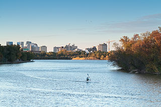
Wascana Centre is a 930-hectare urban park built around Wascana Lake in Regina, Saskatchewan, Canada, established in 1912 with a design from renowned architect Thomas Mawson. The park is designed around the Saskatchewan Legislative Building and Wascana Lake. High-profile features include the University of Regina, Royal Saskatchewan Museum, Conexus Arts Centre, Saskatchewan Science Centre, and CBC Regional Broadcast Centre. Wascana Centre brings together lands and buildings owned by the City of Regina, University of Regina, and Province of Saskatchewan. The park is located immediately south of the city's downtown core, bordered by residential areas on the east, south and west, and on the south-east edge it spills out onto open Saskatchewan prairie along Wascana Creek.

Isabella Dam is an embankment dam located in the Kern River Valley, about halfway down the Kern River course, between the towns of Kernville and Lake Isabella in Kern County, California.
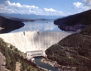
Hungry Horse Dam is an arch dam in the Western United States, on the South Fork Flathead River in the Rocky Mountains of northwest Montana. It is located in Flathead National Forest in Flathead County, about fifteen miles (24 km) south of the west entrance to Glacier National Park, nine miles (14 km) southeast of Columbia Falls, and twenty miles (32 km) northeast of Kalispell. The Hungry Horse project, dam, and powerplant are operated by the U.S. Bureau of Reclamation. The entrance road leading to the dam is located in Hungry Horse.

The Canning Dam and reservoir are a major source of fresh water for the city of Perth, Western Australia. The dam is situated on the Darling Scarp and is an impoundment of the Canning River. It is noted for its innovative structural and hydraulic design that was considered to be at the forefront of concrete gravity dam design at the time of construction in from 1933 to its completion 1940.

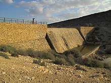
The Besor or Wadi Gaza is a stream in southern Israel and Palestine. The stream begins at Mount Boker, and spills into the Mediterranean Sea near Al-Zahra in the Gaza Strip. Further upstream it was marked as Wadi esh-Shallaleh on the 1878 Survey of Western Palestine map. The area has several important archaeological sites.
The Central Utah Project is a US federal water project that was authorized for construction under the Colorado River Storage Project Act of April 11, 1956, as a participating project. In general, the Central Utah Project develops a portion of Utah's share of the yield of the Colorado River, as set out in the Colorado River Compact of 1922.
Water politics in the Jordan River basin refers to political issues of water within the Jordan River drainage basin, including competing claims and water usage, and issues of riparian rights of surface water along transnational rivers, as well as the availability and usage of ground water. Water resources in the region are scarce, and these issues directly affect the five political subdivisions located within and bordering the basin, which were created since the collapse, during World War I, of the former single controlling entity, the Ottoman Empire. Because of the scarcity of water and a unique political context, issues of both supply and usage outside the physical limits of the basin have been included historically.

Rathbun Lake was constructed and is operated by the U.S. Army Corps of Engineers. Located at Chariton River mile marker 142, approximately 7 miles (11 km) north of Centerville, Iowa, in Appanoose County, it is one of the largest lakes in Iowa. The lake was constructed to control flooding, provide recreation opportunities, abate stream pollution, fish and wildlife enhancement, and maintain minimum stream flow on the Chariton, Missouri, and Mississippi Rivers. The Chariton and South Fork of the Chariton River are the major sources of water flowing into Rathbun Lake.