
The Rocky Mountains, also known as the Rockies, are a major mountain range in western North America. The Rocky Mountains stretch more than 4,800 kilometers (3,000 mi) from the northernmost part of British Columbia, in western Canada, to New Mexico in the Southwestern United States. Located within the North American Cordillera, the Rockies are somewhat distinct from the Pacific Coast Ranges, Cascade Range, and the Sierra Nevada, which all lie farther to the west.

The Himalayas, or Himalaya, form a mountain range in Asia, separating the plains of the Indian subcontinent from the Tibetan Plateau.

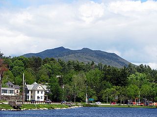
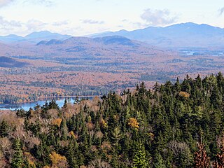
The Adirondack Mountains form a massif in northeastern New York, United States. Its boundaries correspond to the boundaries of Adirondack Park. The mountains form a roughly circular dome, about 160 miles (260 km) in diameter and about 1 mile (1,600 m) high. The current relief owes much to glaciation.

Rocky Mountain National Park is an American national park located approximately 76 mi (122 km) northwest of Denver International Airport in north-central Colorado, within the Front Range of the Rocky Mountains. The park is situated between the towns of Estes Park to the east and Grand Lake to the west. The eastern and westerns slopes of the Continental Divide run directly through the center of the park with the headwaters of the Colorado River located in the park's northwestern region. The main features of the park include mountains, alpine lakes and a wide variety of wildlife within various climates and environments, from wooded forests to mountain tundra.

The Wasatch Range is a mountain range that stretches approximately 160 miles (260 km) from the Utah-Idaho border, south through central Utah in the western United States. It is the western edge of the greater Rocky Mountains, and the eastern edge of the Great Basin region. The northern extension of the Wasatch Range, the Bear River Mountains, extends just into Idaho, constituting all of the Wasatch Range in that state.

A tarn is a mountain lake, pond or pool, formed in a cirque excavated by a glacier. A moraine may form a natural dam below a tarn.
Waterton Lakes National Park is a national park located in the southwest corner of Alberta, Canada. It borders Glacier National Park in Montana, United States. Waterton was the fourth Canadian national park, formed in 1895 and named after Waterton Lake, in turn after the Victorian naturalist and conservationist Charles Waterton. Its range is between the Rocky Mountains and prairies. This park contains 505 km2 (195 sq mi) of rugged mountains and wilderness.

The Uinta Mountains are an east-west trending chain of mountains in northeastern Utah extending slightly into southern Wyoming in the United States. As a subrange of the Rocky Mountains, they are unusual for being the highest range in the contiguous United States running east to west, and lie approximately 100 miles (160 km) east of Salt Lake City. The range has peaks ranging from 11,000–13,528 feet (3,353–4,123 m), with the highest point being Kings Peak, also the highest point in Utah. The Mirror Lake Highway crosses the western half of the Uintas on its way to Wyoming.

The Albertine Rift is the western branch of the East African Rift, covering parts of Uganda, the Democratic Republic of the Congo (DRC), Rwanda, Burundi and Tanzania.
It extends from the northern end of Lake Albert to the southern end of Lake Tanganyika.
The geographical term includes the valley and the surrounding mountains.

The Mountain Lakes Wilderness is a wilderness area located in the Fremont–Winema National Forest in the southern Cascade Range of Oregon in the United States. It surrounds a cluster of four overlapping shield volcanoes, the highest of which is 8,208-foot (2,502 m) Aspen Butte. Over 20 small lakes lie along the bottoms of several large cirques carved by Ice Age glaciers near the summits of the volcanoes.

Lyon Mountain is a mountain located in Clinton County, New York, of which its peak is the highest point.
The mountain is named for Nathaniel Lyon, an early settler of the area who moved from Vermont in 1803 and died circa 1850.

Black Mountain is a mountain located in Washington County, New York, of which its peak is the highest point.
Isolated from the rest of the Adirondack Mountains by Lake George, Black Mtn. has the seventh highest topographic prominence of all the mountains in New York.

Balsam Lake Mountain is one of the Catskill Mountains, located in the Town of Hardenburgh, New York, United States. It is the westernmost of the range's 35 High Peaks. Its exact height has not been determined, but the highest contour line on topographic maps, 3,720 feet (1,130 m), is usually given as its elevation.

Ampersand Mountain is a 3,352 ft (1,021.7 m) mountain in Franklin County in the northeastern Adirondacks, west of the High Peaks in New York State. The trail up the mountain begins on New York State Route 3 8.1 miles (13.0 km) southwest of the village of Saranac Lake, near Middle Saranac Lake; it is a popular day hike. The mountain takes its name from nearby Ampersand Creek, so named because it twists and turns like the ampersand symbol. The summit is bare rock, with extensive views of the High Peaks to the east and the Saranac Lakes to the west. Stony Creek Mountain is located west-southwest of Ampersand Mountain.
McKenzie Mountain is a 3,861-foot (1,177 m) mountain in western Essex County in the towns of St. Armand and North Elba in the Adirondack Park, a unit of the Forest Preserve.

Pyongyang Station is the central railway station of P'yŏngyang, North Korea. It is located in Yŏkchŏn-dong, Chung-guyŏk.
Owls Head Mountain is a 2,812-foot (857 m) mountain in Long Lake, New York in the Adirondack Park.

Silver Lake Mountain is a 2,372 ft mountain in the North-Eastern Adirondacks located near Ausable Forks, NY.


