
The Regional Municipality of York, also called York Region, is a regional municipality in Southern Ontario, Canada, between Lake Simcoe and Toronto. The region was established after the passing of then Bill 102, An Act to Establish The Regional Municipality of York, in 1970. It replaced the former York County in 1971, and is part of the Greater Toronto Area and the inner ring of the Golden Horseshoe. The regional government is headquartered in Newmarket.

The Regional Municipality of Durham, informally referred to as Durham Region, is a regional municipality in Southern Ontario, Canada. Located east of Toronto and the Regional Municipality of York, Durham forms the east-end of the Greater Toronto Area and part of the Golden Horseshoe region. It has an area of approximately 2,500 km2 (970 sq mi). The regional government is headquartered in Whitby.

The Greater Toronto Area, commonly referred to as the GTA, includes the City of Toronto and the regional municipalities of Durham, Halton, Peel, and York. In total, the region contains 25 urban, suburban, and rural municipalities. The Greater Toronto Area begins in Burlington in Halton Region, and extends along Lake Ontario past downtown Toronto eastward to Clarington in Durham Region.

The Golden Horseshoe is a secondary region of Southern Ontario, Canada, which lies at the western end of Lake Ontario, with outer boundaries stretching south to Lake Erie and north to Lake Scugog, Lake Simcoe and Georgian Bay of Lake Huron. The region is the most densely populated and industrialized in Canada. Based on the 2021 census, with a population of 7,759,635 people in its core and 9,765,188 in its greater area, the Golden Horseshoe accounts for over 20 percent of the population of Canada and more than 54 percent of Ontario's population. It is part of the Quebec City–Windsor Corridor, itself part of the Great Lakes megalopolis.

The Regional Municipality of Peel is a regional municipality in the Greater Toronto Area, Southern Ontario, Canada. It consists of three municipalities to the west and northwest of the city of Toronto: the cities of Mississauga and Brampton, and the town of Caledon, each of which spans its full east–west width. The regional seat is in Brampton. The entire Greater Toronto Area is the inner ring of the Golden Horseshoe.
A regional municipality is a type of Canadian municipal government similar to and at the same municipal government level as a county, although the specific structure and servicing responsibilities may vary from place to place. Regional municipalities were formed in highly populated areas where it was considered more efficient to provide certain services, such as water, emergency services, and waste management over an area encompassing more than one local municipality. For this reason, regions may be involved in providing services to residents and businesses.
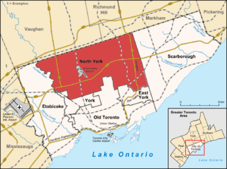
North York is a former township and city and is now one of the six administrative districts of Toronto, Ontario, Canada. It is located directly north of York, Old Toronto and East York, between Etobicoke to the west and Scarborough to the east. As of the 2016 Census, the district has a population of 869,401.
York is a former city within Toronto, Ontario, Canada. It is located northwest of Old Toronto, southwest of North York and east of Etobicoke, where it is bounded by the Humber River. The former city's census districts had a recorded population of 145,662 in 2016.

Simcoe County is located in the central portion of Southern Ontario, Canada. The county is just north of the Greater Toronto Area, stretching from the shores of Lake Simcoe in the east to Georgian Bay in the west. Simcoe County forms part of the Greater Golden Horseshoe area, a densely populated and industrialized region, centred on the Greater Toronto Area.

York County is a historic county in Upper Canada, Canada West, and the Canadian province of Ontario. It was organized by the Upper Canada administration from the lands of the Toronto Purchase and others.
King's Highway 48, also known as Highway 48, is a provincially maintained highway in southern Ontario that extends from Major Mackenzie Drive in Markham, through Whitchurch-Stouffville and East Gwillimbury, to Highway 12 south-east of Beaverton. The route is generally rural and straight, passing near several communities within the Regional Municipality of York. The route is 65.2 kilometres (40.5 mi) long. Most part of the road has a speed limit of 80 km/h (50 mph), except within town limits, where the speed limit is reduced to 60 km/h (37 mph) or 50 km/h (31 mph).
King's Highway 50, commonly referred to as Highway 50, was a provincially maintained highway in the Canadian province of Ontario. The highway, which was decommissioned in 1998, is still referred to as Highway 50, though it is now made up of several county and regional roads: Peel Regional Road 50, York Regional Road 24 and Simcoe County Road 50. The route began in the north end corner of the former Etobicoke at Highway 27 as Albion Road, and travelled northwest to Highway 89 west of the town of Alliston. En route, it passed through the villages of Bolton, Palgrave and Loretto. The road south of Bolton has become more suburban as development has encroached from the east and west; but despite this increased urbanization, the removal of highway status, and the fact that it runs through the former Albion Township, the Albion Road name has not been extended to follow it outside Toronto.
Mount Pleasant, Ontario may refer to:
The City of Toronto Act is the name of a series of different acts of the Legislative Assembly of Ontario that have governed the organization and political powers of the city since Toronto's original incorporation as a city in 1834.
The Bradford Bypass, also known as the Highway 400–404 Link is a proposed east–west 400-series highway in the northern Greater Toronto Area of the Canadian province of Ontario. The approximately 16.2-kilometre (10.1 mi) route is currently undergoing planning and analysis under an environmental impact assessment (EA) by the Ministry of Transportation of Ontario (MTO) and the Government of Ontario. If approved, a new four-lane controlled-access highway would be built between Highway 400 near Bradford in Simcoe County, and Highway 404 near Queensville in York Region. It would serve as a bypass to the north side of Bradford.

The amalgamation of Toronto was the creation of the city limits of Toronto, Ontario, Canada after amalgamating, annexing, and merging with surrounding municipalities since the 18th century. The most recent occurrence of amalgamation was in 1998, which dissolved the federation of Metropolitan Toronto and its constituent municipalities, and created the current "megacity" of Toronto.