
Canada has a vast geography that occupies much of the continent of North America, sharing a land border with the contiguous United States to the south and the U.S. state of Alaska to the northwest. Canada stretches from the Atlantic Ocean in the east to the Pacific Ocean in the west; to the north lies the Arctic Ocean. Greenland is to the northeast with a shared border on Hans Island. To the southeast Canada shares a maritime boundary with France's overseas collectivity of Saint Pierre and Miquelon, the last vestige of New France. By total area, Canada is the second-largest country in the world, after Russia. By land area alone, however, Canada ranks fourth, the difference being due to it having the world's largest proportion of fresh water lakes. Of Canada's thirteen provinces and territories, only two are landlocked while the other eleven all directly border one of three oceans.

Panama, officially the Republic of Panama, is a country in Latin America at the southern end of Central America, bordering South America. It is bordered by Costa Rica to the west, Colombia to the southeast, the Caribbean Sea to the north, and the Pacific Ocean to the south. Its capital and largest city is Panama City, whose metropolitan area is home to nearly half the country's over 4 million inhabitants.

The Panama Canal is an artificial 82-kilometre (51-mile) waterway in Panama that connects the Atlantic Ocean with the Pacific Ocean, cutting across the Isthmus of Panama, and is a conduit for maritime trade. Locks at each end lift ships up to Gatun Lake, an artificial fresh water lake 26 meters (85 ft) above sea level, created by damming up the Chagres River and Lake Alajuela to reduce the amount of excavation work required for the canal. Locks then lower the ships at the other end. An average of 200,000,000 L (52,000,000 US gal) of fresh water is used in a single passing of a ship. The canal is threatened by low water levels during droughts.

Lewisham is a London borough in south-east London, England. It forms part of Inner London. The principal settlement of the borough is Lewisham. The local authority is Lewisham London Borough Council, based in Catford. The Prime Meridian passes through Lewisham. Blackheath, Goldsmiths, University of London and Millwall F.C. are located within the borough.

Randolph County is a county located in the U.S. state of Illinois. According to the 2020 census, it had a population of 30,163. Its county seat is Chester.

Tattnall County is a county located in the southeast portion of the U.S. state of Georgia, located within the Magnolia Midlands, a part of the Historic South region. As of the 2020 census, the population was 22,842. The county seat is Reidsville. Tattnall County was created on December 5, 1801, from part of Montgomery County, Georgia by the Georgia General Assembly.

Lincoln County is a county located in the east central portion of the U.S. state of Georgia. As of the 2020 census, the population was 7,690. The county seat is Lincolnton. The county was created on February 20, 1796.

Johnson County is a county located along the oconee River in the U.S. state of Georgia. As of the 2020 census, the population was 9,189. The county seat is Wrightsville. Johnson County is part of the Dublin, Georgia, micropolitan statistical area.

Jeff Davis County is a county located in the southeastern part of the U.S. state of Georgia. As of the 2020 census, the population was 14,779. The county seat is Hazlehurst. The county was created on August 18, 1905, and named for Jefferson Davis, the only Confederate president.

Echols County is a county located in the southeastern part of the U.S. state of Georgia. As of the 2020 census, the population was 3,697. The county seat is Statenville. Since 2008, Statenville is a disincorporated municipality. Echols and Webster counties are the only two counties in Georgia to currently have no incorporated municipalities. The county was established in 1858 and named in honor of Robert Milner Echols (1798–1847).

Clinton Township is a charter township in Macomb County in the U.S. state of Michigan. A northern suburb of Detroit, Clinton Township is located about 22 miles (35 km) northeast of downtown Detroit. As of the 2020 census, the township had a population of 100,513, making it the most populous township in Michigan, and the state's 8th-most populous community overall.
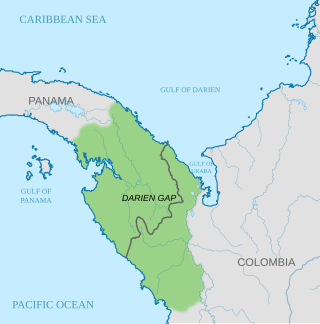
The Darién Gap is a geographic region that connects the American continents, stretching across southern Panama's Darién Province and the northern portion of Colombia's Chocó Department. Consisting of a large watershed, dense rainforest, and mountains, it is known for its remoteness, difficult terrain, and extreme environment, with a reputation as one of the most inhospitable regions in the world. Nevertheless, as the only land bridge between North and South America, the Darién Gap has historically served as a major route for both humans and wildlife.

Los Santos was a province in Panama, reaching from the La Villa river in the North to the Pacific Ocean in the south and east. It is part of the Azuero Peninsula, bounded by the province of Herrera to the north and northeast, and by Mariato District of Veraguas Province to the West. The City of Las Tablas is the capital and most populous city. There are seven administrative districts under the jurisdiction of Los Santos Province. Los Santos's area is 3,809.4 km ², and its population is 98,466 inhabitants in 2023.
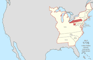
The United States of America was formed after thirteen British colonies in North America declared independence from the British Empire on July 4, 1776. In the Lee Resolution, passed by the Second Continental Congress two days prior, the colonies resolved that they were free and independent states. The union was formalized in the Articles of Confederation, which came into force on March 1, 1781, after being ratified by all 13 states. Their independence was recognized by Great Britain in the Treaty of Paris of 1783, which concluded the American Revolutionary War. This effectively doubled the size of the colonies, now able to stretch west past the Proclamation Line to the Mississippi River. This land was organized into territories and then states, though there remained some conflict with the sea-to-sea grants claimed by some of the original colonies. In time, these grants were ceded to the federal government.
The Canadian territory of Nunavut covers about 1.9 million square kilometres of land and water including part of the mainland, most of the Arctic islands, and all of the islands in Hudson Bay, James Bay, and Ungava Bay which belonged to the Northwest Territories. This makes it the fifth largest country subdivision in the world. If Nunavut were a country, it would rank 13th in area, after the Democratic Republic of the Congo. Nunavut has land borders with Manitoba, the Northwest Territories on several islands as well as the mainland, and a tiny land border with Newfoundland and Labrador on Killiniq Island. Additionally, Nunavut has a land border with Greenland on Hans Island.

Bracken is a village in the Canadian province of Saskatchewan within the Rural Municipality of Lone Tree No. 18 and Census Division No. 4. The village is named after John Bracken, Premier of Manitoba and leader of the Progressive Conservative Party of Canada, who was a professor at the University of Saskatchewan. The small village is located approximately 160 km south of the City of Swift Current on Highway 18, directly north of Grasslands National Park, and approximately 20 km north of the Montana-Saskatchewan border.

The Sixaola River is a river in southern Limón Province, Costa Rica. It flows from the Cordillera Talamanca to the Caribbean Sea northeast of Sixaola at 9°34′20″N82°33′54″W. The river's headwaters are part of the La Amistad International Park. For part of its length, the river forms the border between Limón Province, Costa Rica and Bocas del Toro Province, Panama.
The Costa Rica–Panama border is the 348 km (216 mi) international boundary between Costa Rica and Panama. The border in its present state is demarcated by the Echandi-Fernandez Treaty of 1941.
The Bribri Talamanca Indigenous Territory is one of the four Costa Rican indigenous territories of the Bribri ethnic group. It borders the Talamanca Cabecar Indigenous Territory. It was created by decree in 1985 and is located in the canton of Talamanca, Limón Province. It covers an approximate area of 43,690 hectares of a predominantly mountainous area.
