
Khyber Pakhtunkhwa, formerly known as North West Frontier Province (NWFP), is a province of Pakistan. Located in the northwestern region of the country, Khyber Pakhtunkhwa is the fourth largest province of Pakistan by land area and the third-largest province by population. It is bordered by Balochistan to the south; Punjab, Islamabad Capital Territory, and Azad Kashmir to the east; and Gilgit-Baltistan to the north and northeast. It shares an international border with Afghanistan to the west. Khyber Pakhtunkhwa has a varied geography of rugged mountain ranges, valleys, rolling foothills, and dense agricultural farms.
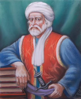
Khošāl Khān Khaṭak (Pashto: خوشال خان خټک; Urdu, Persian: خوشحال خان خٹک; 1613 – 20 February 1689), also known as Khushal Baba, was a 17th-century Pashtun poet, chief, and warrior. Khushal Khan served the Mughal Empire protecting them from Pashtun warriors over most of his lifespan. After being expelled from his tribal chiefdom and replaced with his son by his Mughal superiors, Khushal Khan turned against the Mughals. Afterwards, Khushal preached the union of all Pashtuns, and encouraged revolt against the Mughal Empire, promoting Pashtun nationalism in the last years of his life through poetry. Much of Khushal's poetry is in Pashto but some is also in Persian. Khushal is considered the "father of Pashto literature" and the national poet of Afghanistan.

The Afrīdī are a Pashtun tribe present mostly in tribal areas in Khyber Pakhtunkhwa, Pakistan.

Mardan District is a district in the Mardan Division of the Khyber Pakhtunkhwa province of Pakistan. The district is named after Mardan city, which is also the headquarters of the district. The district is famous for its agriculture industry and its archaeological sites, specifically of Takht-i-Bhai, Jamal Garhi and Sawal Dher.

Nowshera District is a district in the Peshawar Division of the Khyber Pakhtunkhwa province of Pakistan. The capital and district headquarter is Nowshera city.
Ghulam Faruque Khan HPk, CIE, OBE was a Pakistani politician and businessman who was the founder of Ghulam Faruque Group.

Nowshera is the capital city of Nowshera District in the Khyber Pakhtunkhwa province of Pakistan. It is the 78th largest city in Pakistan and ninth largest city in the province of Khyber Pakhtunkhwa.

Ajmal Khan Khattak was a Pakistani politician, writer and Pashto language poet from North-West Frontier Province, who served as the President of Awami National Party. He was a close friend of Khan Abdul Wali Khan.
The history of Peshawar is intertwined with the history of the broader Indian subcontinent. The region was known as Puruṣapura in Sanskrit, literally meaning "city of men". Being among the most ancient cities of the Indian subcontinent, Peshawar had for centuries been a center of trade between West Asia, Central Asia, and the Indian subcontinent.
Pirpiai is a town in the District of Nowshera in Khyber-Pakhtunkhwa, Pakistan. Its population is around 35,000. Pirpiai has a high literacy rate of 92%, compared with Pakistan's average literacy rate of 55%. The village is on GT Road, 8 km from Nowshera Cantonment towards Peshawar. Most of the villagers are working-folk, adding to the work-pool through government service, and self-employment. Substantial number of people from the village are working abroad and adding to national exchequer. The village is rich in producing educated and professional class like engineers, doctors, officers of armed forces, civil servants, professors and so on.
Akbarpura, or Akbarpūra is a village, which is located roughly 13 miles (21 km) northeast of Peshawar and is part of Pabbi Tehsil of Nowshera District of Khyber Pakhtunkhwa in Pakistan. Akbarpura is named after the Mughal Emperor Akbar, who camped there before going to Afghanistan. It was known originally as Sapalikhera. Akbarpura is noted for its Sufi shrines - Baba Saib and Nanga Baba.
Akora Khattak or Sarai Akora is a town in the Jehangira tehsil of the Nowshera District in the Khyber Pakhtunkhwa province of Pakistan. Its location is adjacent to the Kabul River, which converges with the Indus River about 15 kilometres downstream. Neighbouring places are Nowshera Cantonment to the west and Jahangira town to the east.
The History of Khyber Pakhtunkhwa refers to the history of the modern-day Pakistani province of Khyber Pakhtunkhwa.
Jehangira is a town in the Khyber-Pakhtunkhwa province of Pakistan.
Landi Arbab is a village in Peshawar, Pakistan. The village is a 15-minute drive away from Peshawar International Airport and Peshawar Saddar. The village is largely populated by the Qazi, Arbab, Murad Khel, Malaks, Syed, Ahmad Zai, Fateh Khan Khel, Qasab and Ghorghust clans. It is the only village in the area that provides direct routes to Ring Road Peshawar, Peshawar City, Gulberg Peshawar, Peshawar Saddar, Peshawar Cantt, Peshawar International Airport, Kohat Road, Bara Gate, and University Road. The economy is primarily sourced from agriculture and small industries.

The Battle of Nowshera was fought in Nowshera in March 1823 collectively by the Yusufzai Afghans, supported by the Peshawar sardars, alongside Azim Khan Barakzai, the Afghan governor of Peshawar, where they would face the Sikh armies led by Maharaja Ranjit Singh. Azim Khan was a half-brother of Dost Mohammad Khan, the future ruler of Kabul, and later Afghanistan. The battle was a victory for the Sikhs over Azim Khan's armies, a result which allowed the Sikhs to begin their occupation of the Peshawar Valley.
Khattak is a Pashtun/Pakhtun surname found among the pashtuns of northern Pakistan and Afghanistan.

Pervez Khan Khattak is a Pakistani politician who served as the minister of Defence from August 2018 until April 2022. He had been a member of the National Assembly of Pakistan from August 2018 till January 2023. Prior to that, he served as the 22nd chief minister of Khyber Pakhtunkhwa from 2013 to 2018, elected to the Provincial Assembly from Nowshera District. He was a senior member of the Pakistan Tehreek-e-Insaf until July 2023, when he formed his breakaway faction, the Pakistan Tehreek-e-Insaf Parliamentarians (PTI-P). On 12 February 2024, he left the chairmanship of the PTI-P and took a break from politics tenders resignation as PTI-P chairman due to ‘health issues’.
Pabbi is a large town in Pabbi Tehsil of Nowshera District of Khyber-Pakhtunkhwa province of Pakistan. It is located on both sides of the Grand Trunk (GT) around 20-km from Peshawar, the capital of Khyber Pukhtunkhwa province.
Pabbi is a tehsil located in Nowshera District, Khyber-Pakhtunkhwa, Pakistan. The tehsil is named after the Pabbi town, which is located on the GT Road.

