The South West region is one of the nine regions of Western Australia. It has an area of 23,970 km2, and a population of about 170,000 people. Bunbury is the main city in the region.
Woronora is a suburb in southern Sydney, in the state of New South Wales, Australia. Woronora is located 27 kilometres south of the Sydney central business district, in the local government area of the Sutherland Shire. Woronora Heights is a separate suburb, to the south-west.

Woronora Heights is a suburb in southern Sydney, in the state of New South Wales, Australia. Woronora Heights is located 29 kilometres south of the Sydney central business district, in the local government area of the Sutherland Shire. Woronora is a separate suburb, to the north. Most streets in Woronora Heights are named after birds.

The Canning River is a major tributary of the Swan River in the South West Land Division of Western Australia. It is home to much wildlife including dolphins, pelicans, swans and many other bird species.

Cape Tribulation is a headland and coastal locality in the Shire of Douglas in northern Queensland, Australia. In the 2021 census, Cape Tribulation had a population of 123 people.

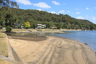
The Woronora River is a perennial river of the Sydney Basin, located in the Sutherland Shire local government area of Greater Metropolitan Sydney, approximately 22 kilometres (14 mi) south of the Sydney central business district, in New South Wales, Australia.

The Nieva River is a tributary of the Marañón River in Peru. It flows through the provinces Bongara and Condorcanqui of the Amazonas Region. Its length, from the east in the mountain range of Campanquiz to the mouth is approximately 150 kilometers.
Taroom is a town in the Shire of Banana and locality split between the Shire of Banana and the Western Downs Region in Queensland, Australia. In the 2021 census, Taroom had a population of 885 people.
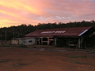
Donnelly River Village is a former timber mill town and present-day holiday village in the Shire of Nannup, in the South West region of Western Australia. The Village is located at a point between Nannup, Bridgetown and Manjimup on the Donnelly River, a small, seasonal river at this point, which flows into the Southern Ocean at 34°29′02.4″S115°40′27.8″E. The name also applies to a winery downstream on the Vasse Highway and the township's cottages are sometimes confused with cottages built on the lower reaches of the Donnelly River at 34°28′56″S115°41′00″E.

Bylong Valley Way is a New South Wales regional road linking Golden Highway near Sandy Hollow to Castlereagh Highway near Ilford. It is named after the Bylong Valley, through which the road passes.

Rumbling Bridge is a small village built on both sides of a gorge of the River Devon, which formed the boundary between the historic counties of Perthshire and Kinross-shire and is now within the combined Perth and Kinross council area, Scotland, where the A823 leaves the A977. It lies roughly 1 mile equidistant from Muckhart to its north, Crook of Devon to its east and Powmill to its south. It is named after an unusual double bridge, which gives off a distinctive rumbling reverberation at lower levels. Comprising only a few scattered houses until the mid-20th century, most property in the village dates from the 1970s onwards.

Ceratodus is a rural town and locality in the North Burnett Region, Queensland, Australia. In the 2021 census, the locality of Ceratodus had a population of 34 people.

The Barry Way is a partly unsealed alpine road running from Jindabyne southwest to the Victoria border, in New South Wales, Australia, where it becomes the Snowy River Road. It eventually leads to Buchan, a total distance of 170 kilometres with no services or towns. It is sealed for the first 27 kilometres from Jindabyne, passing thru the Moonah and Grosses Plain localities and becoming unsealed at Ingebirah Gap, remaining so through the Ingeegoodbee locality as far as the Victorian border. The road passes through some very remote and unspoilt wilderness in the Australian Alps close to the river. The scenery along the road provides views of the Snowy River valley and the surrounding mountains. There are a number of campsites along the road, from Jacobs River southwards and the road passes the Wallace Craigie Lookout.

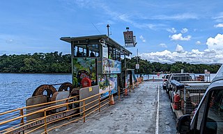
The Sackville Ferry is a cable ferry across the Hawkesbury River in New South Wales, Australia. The vehicular ferry connects the communities of Sackville, on the north/west bank of the river, and Sackville North, on the south/east bank. Because of the tortuous course of the river, the ferry actually runs north-west from Sackville to Sackville North.
The Daintree River Ferry is a cable ferry across the Daintree River between the localities of Forest Creek and Lower Daintree in the Shire of Douglas, Queensland, Australia. The ferry is situated some 50 kilometres (31 mi) north of Port Douglas, and gives access to the northern section of the Daintree National Park and to Cape Tribulation. The ferry provides the only sealed road access to this area.

The Bloomfield Track, which is also known as the Coast Road or officially, the Cape Tribulation-Bloomfield Road, is a controversial four-wheel-drive road in Far North Queensland, Australia. The road's construction through untouched wilderness was the cause of protests and blockades in the early 1980s.

The Walt Whitman Bridge is a single-level suspension bridge spanning the Delaware River from Philadelphia in the west to Gloucester City in Camden County, New Jersey in the east. The bridge is named after American poet and essayist Walt Whitman, who resided in nearby Camden toward the end of his life.

Maldon is a locality in the Macarthur Region of New South Wales, Australia, in the Wollondilly Shire. In the 2016 census it had a population of 15.

Kamerunga is a town and a suburb of Cairns in the Cairns Region, Queensland, Australia. In the 2021 census, the suburb of Kamerunga had a population of 962 people.

The Towamba River bridge is a heritage-listed road bridge that carries Towamba Road across the Towamba River at New Buildings, New South Wales, Australia. The bridge is owned by Transport for NSW. The bridge is also called the New Buildings Bridge over Towamba River. It was added to the New South Wales State Heritage Register on 20 June 2000.