
Burundi is divided into eighteen provinces, each named after their respective capital with the exception of Bujumbura Rural.
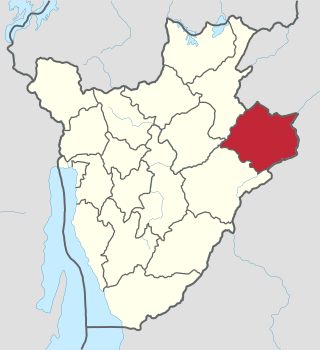
Cankuzo Province is one of the 18 provinces of Burundi. Located in the eastern part of the country, the province covers an area of 1,965 km2. The provincial capital is Cankuzo. It is Burundi's least populated province.
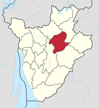
Karuzi Province is one of the 18 provinces of Burundi.
Karuzi, or Karusi, is a city located in eastern Burundi. It is the capital city of Karuzi Province.
Tsidjé is a town located on the island of Grande Comore in the Comoros. It is located 2.98 miles from the country's capital, Moroni.
Shah Nawaz Bhutto Colony is a neighborhood in the Karachi Central district of Karachi, Pakistan. It is administered as part of New Karachi Town.
Sayghan District, also spelt Saighan, Seyghan and other variant spellings, and also known as Saraik or Sarayek, and other variant spellings of this name, is an administrative district of Bamyan province, Afghanistan.
Atokou is a village in western Benin. It is located in Bantè commune in the Collines Department.
Namore is a village in the Bassar Prefecture in the Kara Region of north-western Togo. The village covers 56,785 square kilometers and has an estimated population of 6,961,049 people. The village is located approximately 151 meters above sea level.
Muhib Ali Uttar, is a town and union council of Okara District in the Punjab province of Pakistan. It is part of Depalpur Tehsil. It is located at 30°25'0N 73°37'0E with an altitude of 159 metres. The estimate terrain elevation above sea level is 168 metres.
Burundi is a unitary state which is sub-divided at three levels: provinces, communes, and collines (hills).
Jebiniana is a town and commune in the Sfax Governorate, Tunisia.
Morkwijit is a settlement in Kenya's Rift Valley Province, located in the region of Trans Nzoia. It lies approximately 22 km (13 mi) away from Trans Nzoia's capital, Kitale, and around 334 km (208 mi) from Kenya's capital, Nairobi. The settlement's estimated elevation above sea level is 1,980 meters.

Rumonge Nature Reserve is a protected area in Burundi covering 50 km2 (19 sq mi). It was established in 1980. It is located at an elevation of 1,641 m (5,384 ft).
Darah formerly known as Darah-ye Hazara is a District in Afghanistan, located in Panjshir province. The inhabitants are predominantly Sunni Hazaras. The population in 2019 was estimated to be 15,407.
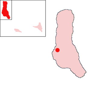
The commune of Nyabikere is a commune of Karuzi Province in central Burundi. The capital lies at Nyabikere.
Boagis Island is an island in Papua New Guinea located in Milne Bay. It is situated 4 km north of Nusam island.
Lugonjo is a neighborhood in Entebbe Municipality, Busiro County, Wakiso District, in the Buganda Region of Uganda.
Nagojje is a town in the Buganda Region of Uganda. It is a municipality in Mukono District.
Ariam Ala-Ala is a village in Ikwuano Local Government Area of Abia State, Nigeria. It is one of 15 localities of the Ariam/Usaka clan. The community is located along the Umuahia-Ikot Ekpene Road and is about 27 km away from the state capital, Umuahia.
