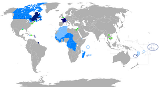
The 1992 African Cup of Nations was the 18th edition of the Africa Cup of Nations, the football championship of Africa (CAF). It was hosted by Senegal. The field expanded to twelve teams, split into four groups of three; the top two teams in each group advanced to the quarterfinals. Ivory Coast won its first championship, beating Ghana on penalty kicks 11−10 after a goalless draw.

The Casamance River flows westward for the most part into the Atlantic Ocean along a path about 200 miles (320 km) in length. However, only 80 miles (130 km) of it are navigable. The Casamance is the principal river of the Kolda, Sédhiou, and Ziguinchor Regions in the southern portion of Senegal between the Gambia and Guinea-Bissau. The three regions are also collectively known as Casamance after the river.

Tambacounda is the largest city in eastern Senegal, 400 kilometres (250 mi) southeast of Dakar, and is the regional capital of the province of the same name. Its estimated population in 2007 was 78,800.
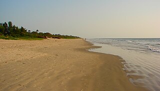
Cap Skirring, also spelled Cap Skiring, is a town on the Atlantic Ocean coast of the Basse Casamance (Ziguinchor) region of Senegal. It is a popular seaside resort with Europeans and has an airport and a golf course. The town was first occupied by fishermen. It was discovered by the French of Ziguinchor as a balneal zone in the 1960s. A landing strip for small planes was built at the end of 1960 by members of the Aero Club de Ziguinchor.
Bignona is a town with commune status located in the Ziguinchor Region of Senegal (Casamance). It briefly appears in the movie Binta and the Great Idea.

Bignona Department is one of the 3 departments in the Ziguinchor Region of Senegal.

Ziguinchor Department is one of the 45 departments of Senegal, one of three located in the Ziguinchor Region in the south-west of the country.
Oussouye Department is one of the departments of Senegal, located in the Ziguinchor Region. It's situated in Basse Casamance, on the right bank of the mouth of the Casamance River.
Mpack is a village in Niaguis Arrondissement, Ziguinchor Department, Ziguinchor Region in southern Senegal. Government statistics classified it as a rural community and recorded its population as 518 people in 72 households. It is located about seven kilometres from the regional capital of Ziguinchor. It is one of the endpoints of the 90-km long Oussouye-Kabrousse-Cap Skirring-Ziguinchor-Mpack road, which is being rebuilt with 17 billion CFA francs of funding from the European Union. The village used to be on the front lines of the Casamance Conflict between the Senegalese government and the Movement of Democratic Forces of Casamance.

Senegal - Diocesi di Ziguinchor.jpg
San Francisco District is one of eight districts of the province Ambo in Peru.
Boucott-Diembéring is a village in the rural community of Diembéring, Cabrousse, Oussouye, Ziguinchor, Casamance.
Badème is a village in the rural community of Nyassia, Nyassia Arrondissement, Ziguinchor Department in the Ziguinchor Region of south-west Senegal, near the border with Guinée-Bissau.
Piaxtla (municipality) is a town and municipality in Puebla in south-eastern Mexico.1000
Elole is a village in the rural community of Djibidione CR, located in the arrondissement of Sindian and Bignona Department, a subdivision of the Ziguinchor Region in the historic region of Casamance in the south of the country.
Bougoutoub Djinoubor is a village in the rural commune of Oulampane, in the Bignona Department of the Ziguinchor Region of Senegal. In 2002 it had a population of 267 people.
Daroukairy is a village in the rural commune of Kataba I, in the Bignona Department of the Ziguinchor Region of southwestern Senegal. In 2002 it had a population of 577 people.
Dimbaya is a village in the rural commune of Kataba I, in the Bignona Department of the Ziguinchor Region of southwestern Senegal. In 2002 it had a population of 213 people.
Kabadio is a village in the rural commune of Kataba I, in the Bignona Department of the Ziguinchor Region of southwestern Senegal. In 2002 it had a population of 1501 people.