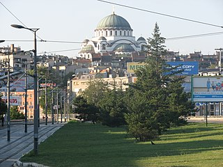
Vračar is a municipality of the city of Belgrade. According to the 2011 census results, the municipality has a population of 56,333 inhabitants.
West Vračar or Zapadni Vračar, is a former urban neighborhood and municipality of Belgrade, the capital of Serbia. It was located in Belgrade's municipality of Savski Venac to which northern section it generally corresponds today.
In Bosnia and Herzegovina the smallest administrative unit is the municipality. Prior to the 1992–95 Bosnian War there were 109 municipalities in what was then Socialist Republic of Bosnia and Herzegovina. Ten of these formed the area of the capital Sarajevo.

Stadion Rođeni is a football stadium in Mostar, Bosnia and Herzegovina. It is located in the northern part of the city. It takes its name from the nickname of FK Velež. It is primarily the home of FK Velež Mostar. The stadium holds 7,000 supporters. It has a little east and a big north tribune built in 2006. In 2008, a big west tribune is under construction.

KTIK is a commercial radio station located in Boise, Idaho, United States. KTIK airs sports/talk programming as an CBS Sports Radio affiliate and is under ownership of Cumulus Media.

Hreša is a mountain village located near Sarajevo, capital of Bosnia and Herzegovina. Hreša is located in Istočni Stari Grad, municipality in City of East Sarajevo, Republika Srpska, Bosnia and Herzegovina. It was also known as Srpski Stari Grad, and was created from part of the pre-war municipality of Stari Grad. Hreša is the biggest place of Istočni Stari Grad.
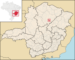
Guaraciama is a Brazilian municipality located in the north of the state of Minas Gerais. Its population as of 2007 was 4,554 people living in a total area of 392 km². The city belongs to the mesoregion of North of Minas and to the microregion of Bocaiúva. It became a municipality in 1997.
Kokorina is a village in Istočni Mostar municipality, Republika Srpska, Bosnia and Herzegovina.

Kamena is a village in Istočni Mostar municipality, Republika Srpska, Bosnia and Herzegovina.

Kei Lun is an at-grade MTR Light Rail stop located at Tsing Lun Road in Tuen Mun District, near Kei Lun Wai. It opened on 18 September 1988 and belongs to Zone 3. It is very different from other Light Rail stops that Line 505 only routes to Siu Hong direction via this stop, but not Sam Shing direction.
Bylew is a village in the administrative district of Gmina Ślesin, within Konin County, Greater Poland Voivodeship, in west-central Poland.
Ostrowąż-Giętkowo is a village in the administrative district of Gmina Ślesin, within Konin County, Greater Poland Voivodeship, in west-central Poland.
Łysek-Sosnówka is a village in the administrative district of Gmina Wierzbinek, within Konin County, Greater Poland Voivodeship, in west-central Poland.

Piękna Studnia is a settlement in the administrative district of Gmina Namysłów, within Namysłów County, Opole Voivodeship, in south-western Poland. It lies approximately 7 kilometres (4 mi) south of Namysłów and 43 km (27 mi) north-west of the regional capital Opole.
Lisewko is a settlement in the administrative district of Gmina Zblewo, within Starogard County, Pomeranian Voivodeship, in northern Poland. It lies approximately 10 kilometres (6 mi) north-east of Zblewo, 11 km (7 mi) north-west of Starogard Gdański, and 43 km (27 mi) south of the regional capital Gdańsk.

Smiljevac is a village in the municipality of Ivanjica, Serbia. According to the 2011 census, the village has a population of 116 inhabitants.
Bulozi is a village in municipality of Istočni Stari Grad, Republika Srpska, Bosnia and Herzegovina.
Kumane is a village in municipality of Istočni Stari Grad, Republika Srpska, Bosnia and Herzegovina.

The ninth electoral unit of Republika Srpska is a parliamentary constituency used to elect members to the National Assembly of Republika Srpska since 2014. It consists of the Municipalities of Nevesinje, Kalinovik, Gacko, Foča, Novo Goražde, Čajniče, Rudo, Berkovići, Ljubinje, Bileća, Trebinje, Višegrad and Istočni Mostar.


