Ziyuan National Geopark

Last updated

Ziyuan National Geopark [1] Chinese :资源国家地质公园 is a park in Ziyuan County, Guangxi, China.

Chinese language family of languages

Chinese is a group of related, but in many cases not mutually intelligible, language varieties, forming the Sinitic branch of the Sino-Tibetan language family. Chinese is spoken by the Han majority and many minority ethnic groups in China. About 1.2 billion people speak some form of Chinese as their first language.

Ziyuan County County in Guangxi, Peoples Republic of China

Ziyuan County is a county in the northeast of Guangxi, China, bordering Hunan province to the north. It is under the administration of the prefecture-level city of Guilin.

Guangxi Autonomous region

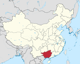
Guangxi ( ; formerly romanised as Kwangsi; Chinese: 广西; Zhuang: Gvangjsih, officially the Guangxi Zhuang Autonomous Region, is an autonomous region of the People's Republic of China, located in south China and bordering Vietnam. Formerly a province, Guangxi became an autonomous region in 1958.

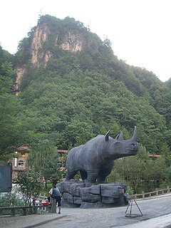
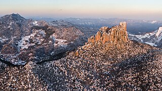
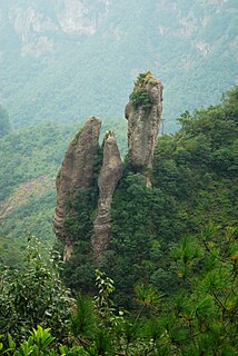
The park's entrance is at the Tianmenshan Scenic Spot which is situated at the middle part of the Geopark, the end of Zijiang driftage route, covering an area of about 5 km in diameter. Steep mountains, magic rocks, caves and streams characterize the park, where there are 38 major rock formations: 19 caves, 2 ponds, 6 springs 8 stone sculptures and so on. The Danxia topography is mainly characterized by dense deep gorges and valleys, and with many ridges and canyons. There are water eroding patterns with snake-like stone girders, as well as grand colluvial caves. The main peak, "Sanniang (the third girl) Stone" is a column that is said to hold up the sky[ citation needed ]. Here in the Ziyuan National Geopark is "The greatest Chinese medicine valley"[ citation needed ] which absorbs almost all the kinds of Chinese herbs used in Chinese medicine. The 16.3 m high sculpture of the Chinese medicine ancestor named "Shennong" honors this valley. There is 50 km2 of virgin forest on top of Shenxianzhai at 630m elevation, which can rarely be found in China. From east to west, where the sky is presenting the line you can see the Heavens Ridge, Peachblossom Island, Shenxianzhai, Sanniang Stone etc. The presentation of Danxia topography includes the fresco showing "the General Riding on a horse to Heavens Gate". The Wangyou Spring is known for to make you forget all the unhappy times in your life.[ citation needed ]

Geopark

A geopark is a unified area that advances the protection and use of geological heritage in a sustainable way, and promotes the economic well-being of the people who live there. There are global geoparks and national geoparks.

Danxia landform

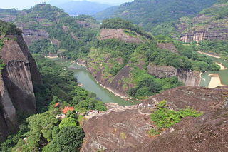
The Danxia landform refers to various landscapes found in southeast, southwest and northwest China that "consist of a red bed characterized by steep cliffs". It is a unique type of petrographic geomorphology found in China. Danxia landform is formed from red-coloured sandstones and conglomerates of largely Cretaceous age. The landforms look very much like karst topography that forms in areas underlain by limestones, but since the rocks that form danxia are sandstones and conglomerates, they have been called "pseudo-karst" landforms. They were formed by endogenous forces and exogenous forces.

Colluvium

Colluvium is a general name for loose, unconsolidated sediments that have been deposited at the base of hillslopes by either rainwash, sheetwash, slow continuous downslope creep, or a variable combination of these processes. Colluvium is typically composed of a heterogeneous range of rock types and sediments ranging from silt to rock fragments of various sizes. This term is also used to specifically refer to sediment deposited at the base of a hillslope by unconcentrated surface runoff or sheet erosion.

Related Research Articles

Travertine A form of limestone deposited by mineral springs

Travertine is a form of limestone deposited by mineral springs, especially hot springs. Travertine often has a fibrous or concentric appearance and exists in white, tan, cream-colored, and even rusty varieties. It is formed by a process of rapid precipitation of calcium carbonate, often at the mouth of a hot spring or in a limestone cave. In the latter, it can form stalactites, stalagmites, and other speleothems. It is frequently used in Italy and elsewhere as a building material.

Langkawi District of Malaysia in Kedah

Langkawi, officially known as Langkawi, the Jewel of Kedah, is a district and an archipelago of 99 islands in the Andaman Sea some 30 km off the mainland coast of northwestern Malaysia. The islands are a part of the state of Kedah, which is adjacent to the Thai border. On 15 July 2008, Sultan Abdul Halim of Kedah consented to the change of name to Langkawi Permata Kedah in conjunction with his golden jubilee celebration. By far the largest of the islands is the eponymous Langkawi Island, with a population of some 64,792; the only other inhabited island being nearby Tuba Island.

Lushan Geopark and Lushan National Park, are located in the region around Mount Lu in the north of Jiangxi Province. The protected area of 500 square kilometres (190 sq mi) extends from the Yangtze River to the Lake Poyang basin.

Sanming Prefecture-level city in Fujian, Peoples Republic of China

Sanming ) is a prefecture-level city in western Fujian province, China. It borders Nanping City to the north, Fuzhou City to the east, Quanzhou City to the southeast, Longyan City to the south, and the province of Jiangxi to the west. Sanming lies between Wuyi and Daiyun mountains.

Mount Danxia mountain range

Mount Danxia is a noted scenic mountainous area near Shaoguan city in the northern part of Guangdong, People's Republic of China.

Kanger Ghati National Park

Kanger Ghati National Park was declared a national park in 1982 by the Government of India.

Zhangjiajie National Forest Park park in Hunan province in China

The Zhangjiajie National Forest Park is a unique national forest park located in Zhangjiajie City in Hunan Province in the People's Republic of China. It is one of several national parks within the Wulingyuan Scenic Area.

Geology of China

The Geology of China can be divided into several parts. The historical centre of Chinese culture is on the loess plateau, the world's largest Quaternary loess deposit, and on the alluvial lands at the east of it. The alluvial East China plain extends from just south of Beijing in the north, to the Yangzi river delta in the south, punctuated only by the igneous Shandong highlands and peninsula. South of the Yangzi river, most of the landscape is mountainous, dominated by sedimentary deposits and by the Yangzi craton. The most famous scenery in China is found in the karst landscapes of Guangxi and Yunnan provinces. The alluvial Sichuan basin is surrounded by mountains, the Qinling mountains to the north and the Himalaya to the west and southwest. Much of Northeast China, or Manchuria, is dominated by alluvial plains, but the border regions with Korea are also highly mountainous. In the west, most of the Tibetan plateau is in China, and averages over 4000 metres in elevation. The Yunnan-Guizhou plateau is also an extension of the Tibetan plateau.

Stone Forest

The Stone Forest or Shilin is a notable set of limestone formations about 500 km2 located in Shilin Yi Autonomous County, Yunnan Province, People's Republic of China, near Shilin approximately 90 km (56 mi) from the provincial capital Kunming.

Fforest Fawr Geopark

Fforest Fawr Geopark was the first Geopark to be designated in Wales having gained membership of both the European Geoparks Network and the UNESCO-assisted Global Network of National Geoparks in October 2005. The Geopark aims to promote and support sustainable tourism and other opportunities to improve the economy of the area whilst safeguarding the natural environment. Its aims largely coincide with the statutory duties and purpose of the National Park within which it sits.

Heshigten Global Geopark

Heshigten Global Geopark is a UNESCO Global Geopark in Hexigten Banner, Chifeng city, Inner Mongolia, China. Its 1,750 km2 area is contained in eight separate areas of scenic beauty and geologic significance, including volcanic, glacial, and desert features.

Renhua County County in Guangdong, Peoples Republic of China

Renhua is a county of northernmost Guangdong province, China, bordering Jiangxi to the northeast and Hunan to the northwest. It is under the administration of Shaoguan City.

Pujiang County, Zhejiang County in Zhejiang, Peoples Republic of China

Pujiang is a county of Zhejiang, China. It is under the administration of the Jinhua city.

Three Natural Bridges

The Three Natural Bridges are a series of natural limestone bridges located in Xiannüshan Town (仙女山镇), Wulong District, Chongqing Municipality, China. They lie within the Wulong Karst National Geology Park, itself a part of the South China Karst-Wulong Karst UNESCO World Heritage Site. In Chinese, the bridges are all named after dragons, namely Tianlong Qinglong and Heilong.

Tawe-Uchaf

Tawe-Uchaf is a community in Powys, Wales. Situated north-east of Ystradgynlais in the upper valley of the Afon Tawe, it includes the villages of Caehopkin, Coelbren, Glyntawe, Pen-y-cae, and Ynyswen. It had a population in 2001 of 1,516, increasing at the 2011 Census to 1,562.

Yandang Mountains

Yandang Mountains or Yandangshan refers, in the broad sense, to a coastal mountain range in southeastern Zhejiang province in eastern China, covering much of the prefecture-level city of Wenzhou and extending to the county-level city of Wenling in Taizhou prefecture. The mountain range is divided in two by the Oujiang River, the two parts being the North Yandang and South Yandang. More narrowly, Yandangshan is also used more narrowly to refer to Mount Yandang, a specific part of the North Yandang around an ancient caldera near a small town of the same name. The highest peaks of North Yandang are located here, and this is also the main tourist spot. In this article, name "Yandang Mountains" is used to refer the mountain range and "Mt. Yandang" to refer to the caldera.

Zhangye National Geopark national geopark in China

The Zhangye National Geopark is located in Sunan and Linze counties within the prefecture-level city of Zhangye, in Gansu, China. It covers an area of 322 square kilometres (124 sq mi). The site became a quasi-national geopark on April 23, 2012. It was formally designated as "Zhangye National Geopark" by the Ministry of Land and Resources on June 16, 2016 after it has passed the on-site acceptance test. Known for its colorful rock formations, it has been voted by Chinese media outlets as one of the most beautiful landforms in China.

Mount Mian mountain (Shanxi Sheng, China)

Mount Mian, also known by its Chinese name Mianshan, is a mountain in the town of Mianshan in Jiexiu, Jinzhong, in central Shanxi Province in north China. Its official scenic area opened in the year 2000 and covers 75 km2 (29 sq mi), with about 400 attractions grouped into 14 tourist areas.

Gunung Sewu Geopark mountain in Indonesia

Gunung Sewu Geopark or Sewu Mountains is a series of mountains stretching along the southern coast of Gunung Kidul Regency and Wonogiri Regency of Central Java, to Tulungagung Regency of East Java in the island of Java, Indonesia. This is a national Geopark, which is also a member of Global Geopark Network (GGN), recognized by UNESCO in 2015.

References