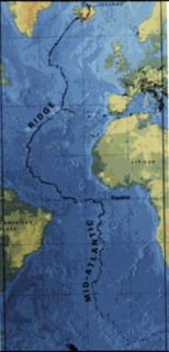
The Mid-Atlantic Ridge (MAR) is a mid-ocean ridge, a divergent tectonic plate or constructive plate boundary located along the floor of the Atlantic Ocean, and part of the longest mountain range in the world. In the North Atlantic it separates the Eurasian and North American plates, and in the South Atlantic it separates the African and South American plates. The ridge extends from a junction with the Gakkel Ridge northeast of Greenland southward to the Bouvet Triple Junction in the South Atlantic. Although the Mid-Atlantic Ridge is mostly an underwater feature, portions of it have enough elevation to extend above sea level. The section of the ridge that includes Iceland is known as the Reykjanes Ridge. The ridge has an average spreading rate of about 2.5 centimetres (0.98 in) per year.

The European route E 22 is one of the longest European routes. It has a length of about 5,320 km (3,310 mi). Many of the E-roads have been extended into Asia since the year 2000; the E 22 was extended on 24 June 2002.

Wabash Township is one of thirteen townships in Tippecanoe County, Indiana, United States. As of the 2010 census, its population was 59,279 and it contained 21,448 housing units making it the most populous township in Tippecanoe County.
Rose Hall is a community in the East Berbice-Corentyne Region of Guyana, located at 6°16′0″N57°21′0″W. Rose Hall is 14 miles east of New Amsterdam, and is the smallest town in Guyana.
German submarine U-388 was a Type VIIC U-boat of Nazi Germany's Kriegsmarine during World War II.

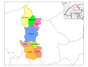
Piéla is a department or commune of Gnagna Province in northern Burkina Faso. Its capital lies at the town of Piela.
Tanama is a village in the Boudry Department of Ganzourgou Province in central Burkina Faso. The village has a population of 532.
Boulyendé is a town in the Manni Department of Gnagna Province in eastern Burkina Faso. The town has a population of 1,112.

Nares is a former settlement in Fresno County, California. It was located on the Southern Pacific Railroad 0.5 miles (0.80 km) northwest of Helm, at an elevation of 187 feet. It still appeared on maps as of 1925.
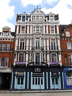
The White Lion is a Grade II listed public house at 14–16 High Street, Putney, London, close to the southern end of Putney Bridge.
German submarine U-611 was a Type VIIC U-boat built for Nazi Germany's Kriegsmarine for service during World War II. She was laid down on 22 April 1941 by Blohm & Voss, Hamburg as yard number 587, launched on 8 January 1942 and commissioned on 26 February 1942 under Kapitänleutnant Nikolaus von Jacobs.

Homage to Leonardo, sometimes referred to as Vitruvian Man for being a representation of the drawing of the same name by Leonardo da Vinci, is an outdoor statue by Italian sculptor Enzo Plazzotta, located at Belgrave Square in London, United Kingdom. The statue was completed posthumously by Plazzotta's assistant Mark Holloway in 1982, and was installed in 1984.

The Bedford Hotel is a Grade II listed public house at 77 Bedford Hill, Balham, London SW12 9HD.

German submarine U-2359 was a Type XXIII U-boat of Nazi Germany's Kriegsmarine during World War II. She was ordered on 20 September 1944, and was laid down on 3 November 1944 at Deutsche Werft AG, Hamburg, as yard number 513. She was launched on 23 December 1944 and commissioned under the command of Oberleutnant zur See Gustav Bischoff on 16 January 1945.
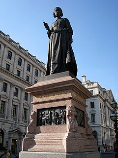
The statue of Florence Nightingale is an outdoor Grade II-listed sculpture in London, United Kingdom. It was sculpted in 1915 by Arthur George Walker, and is a subsidiary part of the Guards Crimean War Memorial.